The Blue Marble, a photograph of the planet Earth made on 7 December 1972 by the crew of the Apollo 17 spacecraft.
The world is the totality of entities, the whole of reality, or everything that exists. The nature of the world has been conceptualized differently in different fields. Some conceptions see the world as unique, while others talk of a "plurality of worlds". Some treat the world as one simple object, while others analyze the world as a complex made up of parts.
In scientific cosmology, the world or universe is commonly defined as "the totality of all space and time; all that is, has been, and will be". Theories of modality talk of possible worlds as complete and consistent ways how things could have been. Phenomenology, starting from the horizon of co-given objects present in the periphery of every experience, defines the world as the biggest horizon, or the "horizon of all horizons". In philosophy of mind, the world is contrasted with the mind as that which is represented by the mind.
Theology conceptualizes the world in relation to God, for example, as God's creation, as identical to God, or as the two being interdependent. In religions, there is a tendency to downgrade the material or sensory world in favor of a spiritual world to be sought through religious practice. A comprehensive representation of the world and our place in it, as is found in religions, is known as a worldview. Cosmogony is the field that studies the origin or creation of the world, while eschatology refers to the science or doctrine of the last things or of the end of the world.
The Blue Marble, taken by either Ron Evans or Harrison Schmitt of the Apollo 17 crew in 1972. The original photograph was taken with the South Pole facing the top; however, this version is the most widely distributed.
The Blue Marble is a photograph of Earth taken on December 7, 1972, by either Ron Evans or Harrison Schmitt aboard the Apollo 17 spacecraft on its way to the Moon. Viewed from around 29,400 km (18,300 mi) from Earth's surface, a cropped and rotated version has become one of the most reproduced images in history.
Protestors clash with Hong Kong police in the Wan Chai waterfront area during the WTO Ministerial Conference of 2005. Since its creation in 1995, the World Trade Organization (WTO) has worked to maintain and develop international trade. As one of the largest international economic organizations (alongside the International Monetary Fund (IMF) and the World Bank), it has strong influence and control over trading rules and agreements, and thus has the ability to affect a country's economy immensely. The WTO policies aim to balance tariffs and other forms of economic protection with a trade liberalization policy, and to "ensure that trade flows as smoothly, predictably and freely as possible". Indeed, the WTO claims that its actions "cut living costs and raise standards, stimulate economic growth and development, help countries develop, [and] give the weak a stronger voice." Statistically speaking, global trade has consistently grown between one and six percent per annum over the past decade, and US$38.8 billion were allocated to Aid for Trade in 2016.
Yet several criticisms of the WTO have arisen over time from a range of fields, including economists such as Dani Rodrik and Ha Joon Chang, and anthropologists such as Marc Edelman, who have argued that the institution "only serves the interests of multinational corporations, undermines local development, penalizes poor countries, [and] is increasing inequality", and have argued that some agreements about agriculture and pharmaceutical goods have led to restricted access to food and healthcare, thus causing large numbers of deaths. Several factors are alleged to contribute to these conditions, including but not limited to: the most favoured nation rule (MFN), national treatment policies, and failure to regard the infant industry argument. Critics argue that the policies that support these principles fail to protect developing nations, and in some cases take advantage of them. For example, UNCTAD estimates that market distortions cost developing countries $700 billion annually in lost export revenue. (Full article...)
Image 3
Leibniz representation of universe resulting by combination of Aristotle four elements The classical elements typically refer to earth, water, air, fire, and (later) aether which were proposed to explain the nature and complexity of all matter in terms of simpler substances. Ancient cultures in Greece, Angola, Tibet, India, and Mali had similar lists which sometimes referred, in local languages, to "air" as "wind", and to "aether" as "space".
These different cultures and even individual philosophers had widely varying explanations concerning their attributes and how they related to observable phenomena as well as cosmology. Sometimes these theories overlapped with mythology and were personified in deities. Some of these interpretations included atomism (the idea of very small, indivisible portions of matter), but other interpretations considered the elements to be divisible into infinitely small pieces without changing their nature. (Full article...)
The Paris Agreement has a long-term temperature goal which is to keep the rise in global surface temperature to well below 2 °C (3.6 °F) above pre-industrial levels. The treaty also states that preferably the limit of the increase should only be 1.5 °C (2.7 °F). These limits are defined as averages of the global temperature as measured over many years. (Full article...)
Image 5
Early in the COVID-19 pandemic, convention centers (pictured here) were deemed to be ideal sites for temporary hospitals, due to their existing infrastructure (electrical, water, sewage). Hotels and dormitories were also considered appropriate because they can use negative pressure technology.
A pandemic (/pænˈdɛmɪk/pan-DEM-ik) is an epidemic of an infectious disease that has a sudden increase in cases and spreads across a large region, for instance multiple continents or worldwide, affecting a substantial number of individuals. Widespread endemic diseases with a stable number of infected individuals such as recurrences of seasonal influenza are generally excluded as they occur simultaneously in large regions of the globe rather than being spread worldwide.
The report "assesses the ability of countries to provide high levels of prosperity to their citizens". This in turn depends on how productively a country uses available resources. Therefore, the Global Competitiveness Index measures the set of institutions, policies, and factors that set the sustainable current and medium-term levels of economic prosperity." (Full article...)
The Hereford Mappa Mundi (Latin: mappa mundi, map of the world) is the largest medieval map still known to exist, depicting the known world. It is a religious rather than literal depiction, featuring heaven, hell and the path to salvation. Dating from ca. AD 1300, the map is drawn in a form deriving from the T and O pattern. It is displayed at Hereford Cathedral in Hereford, England. The map was created as an intricate work of art rather than as a navigational tool. Sources for the information presented on the map include the Alexander tradition, medieval bestiaries and legends of monstrous races, as well as the Bible.
Although the evidence is circumstantial, recent work links the map with the promotion of the cult of Thomas de Cantilupe. Others link the map to a justification of the expulsion of Jewry from England. Potentially antisemitic images include a horned Moses and a depiction of Jews worshipping the Golden Calf in the form of a Saracen devil. The map may also reflect very patriarchal views of women as inherently sinful, including figures such as the wife of Lot being turned into a pillar of salt for gazing at the city of Sodom. Cantilupe was known for his dislike of Jews; in historian Debra Strickland's opinion he was regarded as misogynistic even by the standards of his own time. (Full article...)
Image 2Chloroplasts in the cells of a moss (from History of Earth)
Image 3An animation of the changing density of productive vegetation on land (low in brown; heavy in dark green) and phytoplankton at the ocean surface (low in purple; high in yellow) (from Earth)
Image 6Geologic map of North America, color-coded by age. From most recent to oldest, age is indicated by yellow, green, blue, and red. The reds and pinks indicate rock from the Archean.
Image 18Angkor Wat temple complex, Cambodia, early 12th century
Image 19Artist's impression of the enormous collision that probably formed the Moon (from History of Earth)
Image 20Pangaea was a supercontinent that existed from about 300 to 180 Ma. The outlines of the modern continents and other landmasses are indicated on this map. (from History of Earth)
Image 28Portrait of Alfraganus in the Compilatio astronomica, 1493. Islamic astronomers began just before the 9th century to collect and translate Indian, Persian and Greek astronomical texts, adding their own astronomy and enabling later, particularly European astronomy to build on. Symbolic for the post-classical period, a period of an increasing trans-regional literary culture, particularly in the sciences, spreading and building on methods of science. (from Human history)
Image 32The replicator in virtually all known life is deoxyribonucleic acid. DNA is far more complex than the original replicator and its replication systems are highly elaborate. (from History of Earth)
Image 34Earth's night-side upper atmosphere appearing from the bottom as bands of afterglow illuminating the troposphere in orange with silhouettes of clouds, and the stratosphere in white and blue. Next the mesosphere (pink area) extends to the orange and faintly green line of the lowest airglow, at about one hundred kilometers at the edge of space and the lower edge of the thermosphere (invisible). Continuing with green and red bands of aurorae stretching over several hundred kilometers. (from Earth)
Image 36A schematic view of Earth's magnetosphere with solar wind flowing from left to right (from Earth)
Image 37Conjectured illustration of the scorched Earth after the Sun has entered the red giant phase, about 5–7 billion years in the future (from Earth)
Image 42A 2012 artistic impression of the early Solar System's protoplanetary disk from which Earth and other Solar System bodies were formed (from Earth)
Image 43The first airplane, the Wright Flyer, flew on 17 December 1903.
Image 46A view of Earth with its global ocean and cloud cover, which dominate Earth's surface and hydrosphere; at Earth's polar regions, its hydrosphere forms larger areas of ice cover. (from Earth)
Image 49Artist's impression of a Hadean landscape with the relatively newly formed Moon still looming closely over Earth and both bodies sustaining strong volcanism. (from History of Earth)
Image 56Tiktaalik, a fish with limb-like fins and a predecessor of tetrapods. Reconstruction from fossils about 375 million years old. (from History of Earth)
Image 57Artist's rendition of an oxinated fully-frozen Snowball Earth with no remaining liquid surface water. (from History of Earth)
Image 58Japanese depiction of a Portuguese carrack, a result of globalizing maritime trade
Image 59Exaggerated illustration of Earth's elliptical orbit around the Sun, marking that the orbital extreme points (apoapsis and periapsis) are not the same as the four seasonal extreme points, the equinox and solstice (from Earth)
Image 60An artist's impression of the Archean, the eon after Earth's formation, featuring round stromatolites, which are early oxygen-producing forms of life from billions of years ago. After the Late Heavy Bombardment, Earth's crust had cooled, its water-rich barren surface is marked by continents and volcanoes, with the Moon still orbiting Earth half as far as it is today, appearing 2.8 times larger and producing strong tides. (from Earth)
Image 63Earth's history with time-spans of the eons to scale. Ma means "million years ago". (from History of Earth)
Image 64Earth's axial tilt causing different angles of seasonal illumination at different orbital positions around the Sun (from Earth)
Image 65Trilobites first appeared during the Cambrian period and were among the most widespread and diverse groups of Paleozoic organisms. (from History of Earth)
Image 71Artist's impression of Earth during the later Archean, the largely cooled planetary crust and water-rich barren surface, marked by volcanoes and continents, features already roundmicrobialites. The Moon, still orbiting Earth much closer than today and still dominating Earth's sky, produced strong tides. (from History of Earth)
Image 80Earth's western hemisphere showing topography relative to Earth's center instead of to mean sea level, as in common topographic maps (from Earth)
Image 82Change in average surface air temperature and drivers for that change. Human activity has caused increased temperatures, with natural forces adding some variability. (from Earth)
Image 8313th-century French historiated initial with the three classes of medieval society: those who prayed (the clergy), those who fought (the knights), and those who worked (the peasantry)
Seoul's history traces back to 18 BC when it was founded by the people of Baekje, one of the Three Kingdoms of Korea. During the Joseon dynasty, Seoul was officially designated as the capital, surrounded by the Fortress Wall of Seoul. In the early 20th century, Seoul was occupied by the Japanese Empire, temporarily renamed "Keijō" ("Gyeongseong" in Korean). The Korean War brought fierce battles, with Seoul changing hands four times and leaving the city mostly in ruins. Nevertheless, the city has since undergone significant reconstruction and rapid urbanization. (Full article...)
... that Beryl Benacerraf, pioneer of the nuchal scan, wrote that dyslexia caused her to live in a world of images where "anomalies jump out at me like a neon sign"?
... that Syrian vlogger Hayla Ghazal used online humour to explore the limitations placed on women in the Arab world?
... that Taylor Swift said that her first live album, Speak Now World Tour – Live, was meant to capture what she wanted to "show [...] my kids and my grandkids"?
Inhabited by Kalinago people since the 13th century, and prior to that by other Indigenous peoples, Barbados was claimed for the Crown of Castile by Spanish navigators in the late 15th century. It first appeared on a Spanish map in 1511. The Portuguese Empire claimed the island between 1532 and 1536, but abandoned it in 1620 with their only remnants being the introduction of wild boars to supply of meat whenever the island was visited. An English ship, the Olive Blossom, arrived in Barbados on 14 May 1625; its men took possession of the island in the name of King James I. In 1627, the first permanent settlers arrived from England, and Barbados became an English and later British colony. During this period, the colony operated on a plantation economy, relying on the labour of African slaves who worked on the island's plantations. Slavery continued until it was phased out through most of the British Empire by the Slavery Abolition Act 1833. (Full article...)
The Seven Wonders of the Ancient World, also known as the Seven Wonders of the World or simply the Seven Wonders, is a list of seven notable structures present during classical antiquity. The first known list of seven wonders dates back to the 2nd–1st century BC.
While the entries have varied over the centuries, the seven traditional wonders are the Great Pyramid of Giza, the Colossus of Rhodes, the Lighthouse of Alexandria, the Mausoleum at Halicarnassus, the Temple of Artemis, the Statue of Zeus at Olympia, and the Hanging Gardens of Babylon. Using modern-day countries, two of the wonders were located in Greece, two in Turkey, two in Egypt, and one in Iraq. Of the seven wonders, only the Pyramid of Giza, which is also by far the oldest of the wonders, remains standing, while the others have been destroyed over the centuries. There is scholarly debate over the exact nature of the Hanging Gardens, and there is doubt as to whether they existed at all. (Full article...)
The headquarters of the National Parks Service are in downtown Buenos Aires, on Santa Fe Avenue. A library and information centre are open to the public. The administration also covers the national monuments, such as the Jaramillo Petrified Forest, and natural and educational reserves. (Full article...)
A view of Kaptai National Park This is a list of protected areas of Bangladesh. Bangladesh is a country in South Asia. There are 53 Protected Areas contains about 818247.46 hectares (Terrestrial & Marine). Out of this, Terrestrial Protectet Areas contains 470147.46 hectares which represents 3.19% area of the country. Protected areas include:
Estonia has five national parks, 167 nature reserves and 152 landscape conservation areas. In addition, there are 116 (118) protected areas with an old (Soviet-era) protection regulation and 537 parks. In total, 18.1% of Estonia are protected nature areas, with Lääne County having the highest percentage (32%) and Põlva County the lowest percentage of protected areas, about 9%. (Full article...)
Image 14
The sun over the Lake Niassa Reserve Protected areas in Mozambique are known as conservation areas, and are currently grouped into national parks, national reserves, forest reserves, wildlife utilisation areas (coutadas), community conservation areas, and private game farms (fazendas de bravio). There are also a number of areas that have been declared as protected areas under a variety of different legislation, which for reasons of simplicity are here grouped together as "other protected areas." Under the Conservation Law of 2014 (Law 16/2014 of June 20), protected areas will need to be reclassified into a much more flexible series of new categories which are closer to the international system used by the IUCN. International initiatives such as transfrontier parks are grouped at the end of the page. (Full article...)
Image 7Only a few of the largest large igneous provinces appear (coloured dark purple) on this geological map, which depicts crustal geologic provinces as seen in seismic refraction data


.jpg)

 Florence, birthplace of the Italian Renaissance
 Chloroplasts in the cells of a moss (from History of Earth)
 An animation of the changing density of productive vegetation on land (low in brown; heavy in dark green) and phytoplankton at the ocean surface (low in purple; high in yellow) (from Earth)
 An artist's rendering of a protoplanetary disk (from History of Earth)
 Vitruvian Man by Leonardo da Vinci epitomizes the advances in art and science seen during the Renaissance. (from History of Earth)
 Geologic map of North America, color-coded by age. From most recent to oldest, age is indicated by yellow, green, blue, and red. The reds and pinks indicate rock from the Archean.

 Taj Mahal, Mughal Empire, India
 Image of the physical world, captured by the Hubble Space Telescope (from World)
 Tracy Caldwell Dyson, a NASA astronaut, observing Earth from the Cupola module at the International Space Station on 11 September 2010 (from Earth)
 Notre-Dame de Paris, France
 Olmec colossal head, now at the Museo de Antropología de Xalapa
 Earth's land use for human agriculture in 2019 (from Earth)
 Artist's conception of Hadean Eon Earth, when it was much hotter and inhospitable to all forms of life. (from History of Earth)
 Angkor Wat temple complex, Cambodia, early 12th century
 Artist's impression of the enormous collision that probably formed the Moon (from History of Earth)
 Pangaea was a supercontinent that existed from about 300 to 180 Ma. The outlines of the modern continents and other landmasses are indicated on this map. (from History of Earth)
 Chennakesava Temple, Belur, India
 Standing Buddha from Gandhara, 2nd century CE
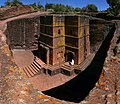 One of the eleven Rock-hewn Churches of Lalibela constructed during the Zagwe dynasty in Ethiopia (from Human history)
 A 580 million year old fossil of Spriggina floundensi, an animal from the Ediacaran period. Such life forms could have been ancestors to the many new forms that originated in the Cambrian Explosion. (from History of Earth)
 Successive dispersals of Homo erectus (yellow), Homo neanderthalensis (ochre) during Out of Africa I and Homo sapiens (red, Out of Africa II), with the numbers of years since they appeared before present. (from Human history)
 Dinosaurs were the dominant terrestrial vertebrates throughout most of the Mesozoic (from History of Earth)
 Portrait of Alfraganus in the Compilatio astronomica, 1493. Islamic astronomers began just before the 9th century to collect and translate Indian, Persian and Greek astronomical texts, adding their own astronomy and enabling later, particularly European astronomy to build on. Symbolic for the post-classical period, a period of an increasing trans-regional literary culture, particularly in the sciences, spreading and building on methods of science. (from Human history)
 Obelisk of Axum, Ethiopia
 A map of heat flow from Earth's interior to the surface of Earth's crust, mostly along the oceanic ridges (from Earth)
 Pale orange dot, an artist's impression of Early Earth, featuring its tinted orange methane-rich early atmosphere (from Earth)
 The replicator in virtually all known life is deoxyribonucleic acid. DNA is far more complex than the original replicator and its replication systems are highly elaborate. (from History of Earth)
 Earth's night-side upper atmosphere appearing from the bottom as bands of afterglow illuminating the troposphere in orange with silhouettes of clouds, and the stratosphere in white and blue. Next the mesosphere (pink area) extends to the orange and faintly green line of the lowest airglow, at about one hundred kilometers at the edge of space and the lower edge of the thermosphere (invisible). Continuing with green and red bands of aurorae stretching over several hundred kilometers. (from Earth)
 European migrations by mostly Germanic peoples, 2nd–6th centuries (from Human history)
 A schematic view of Earth's magnetosphere with solar wind flowing from left to right (from Earth)
 A reconstruction of human history based on fossil data. (from History of Earth)
 Shanghai. China urbanized rapidly in the 21st century.
 A 2012 artistic impression of the early Solar System's protoplanetary disk from which Earth and other Solar System bodies were formed (from Earth)
 The first airplane, the Wright Flyer, flew on 17 December 1903.
 Machu Picchu, Inca Empire, Peru
 Fall of the Berlin Wall, 1989
 A view of Earth with its global ocean and cloud cover, which dominate Earth's surface and hydrosphere; at Earth's polar regions, its hydrosphere forms larger areas of ice cover. (from Earth)
 Great Pyramids of Giza, Egypt
 Artist's impression of a Hadean landscape with the relatively newly formed Moon still looming closely over Earth and both bodies sustaining strong volcanism. (from History of Earth)
 A view of Earth with different layers of its atmosphere visible: the troposphere with its clouds casting shadows, a band of stratospheric blue sky at the horizon, and a line of green airglow of the lower thermosphere around an altitude of 100 km, at the edge of space (from Earth)
 A composite image of artificial light emissions at night on a map of Earth (from Earth)
 Pillar erected by Ashoka, a Mauryan Emperor in India
 A banded iron formation from the 3.15 Ga Moodies Group, Barberton Greenstone Belt, South Africa. Red layers represent the times when oxygen was available; gray layers were formed in anoxic circumstances. (from History of Earth)
 A computer-generated image mapping the prevalence of artificial satellites and space debris around Earth in geosynchronous and low Earth orbit (from Earth)
 A pillar at Neolithic Göbekli Tepe
 Tiktaalik, a fish with limb-like fins and a predecessor of tetrapods. Reconstruction from fossils about 375 million years old. (from History of Earth)
 Artist's rendition of an oxinated fully-frozen Snowball Earth with no remaining liquid surface water. (from History of Earth)
 Japanese depiction of a Portuguese carrack, a result of globalizing maritime trade
 An artist's impression of the Archean, the eon after Earth's formation, featuring round stromatolites, which are early oxygen-producing forms of life from billions of years ago. After the Late Heavy Bombardment, Earth's crust had cooled, its water-rich barren surface is marked by continents and volcanoes, with the Moon still orbiting Earth half as far as it is today, appearing 2.8 times larger and producing strong tides. (from Earth)
 A composite image of Earth, with its different types of surface discernible: Earth's surface dominating Ocean (blue), Africa with lush (green) to dry (brown) land and Earth's polar ice in the form of Antarctic sea ice (grey) covering the Antarctic or Southern Ocean and the Antarctic ice sheet (white) covering Antarctica. (from Earth)
 Graph showing range of estimated partial pressure of atmospheric oxygen through geologic time (from History of Earth)
 Earth's history with time-spans of the eons to scale. Ma means "million years ago". (from History of Earth)
 Earth's axial tilt causing different angles of seasonal illumination at different orbital positions around the Sun (from Earth)
 Trilobites first appeared during the Cambrian period and were among the most widespread and diverse groups of Paleozoic organisms. (from History of Earth)
 Empires of the world in 1898
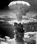
 Benin Bronze head from Nigeria
 COVID-19 pandemic, 2020 (from Human history)
 Artist's conception of Devonian flora (from History of Earth)
 Cuneiform inscription, eastern Turkey
 Lithified stromatolites on the shores of Lake Thetis, Western Australia. Archean stromatolites are the first direct fossil traces of life on Earth. (from History of Earth)
 Ming dynasty section, Great Wall of China
 Last Moon landing: Apollo 17 (1972)
 An artist's impression of ice age Earth at glacial maximum. (from History of Earth)
 Satellite time lapse imagery of Earth's rotation showing axis tilt (from Earth)
 Earth's western hemisphere showing topography relative to Earth's center instead of to mean sea level, as in common topographic maps (from Earth)
 Battle during the 1281 Mongol invasion of Japan
 Change in average surface air temperature and drivers for that change. Human activity has caused increased temperatures, with natural forces adding some variability. (from Earth)
 13th-century French historiated initial with the three classes of medieval society: those who prayed (the clergy), those who fought (the knights), and those who worked (the peasantry)
 Carving of Persian and Median soldiers, Persepolis, Achaemenid Empire, 5th century BCE
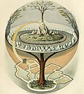 Yggdrasil, an attempt to reconstruct the Norse world tree which connects the heavens, the world, and the underworld. (from World)
 A reconstruction of Pannotia (550 Ma). (from History of Earth)
 Cross-section through a liposome (from History of Earth)


.jpg)

.svg)


.jpeg)


.jpg)


.png)


_(cropped).jpg)


.svg)


.jpg)
 The Goode homolosine projection is a pseudocylindrical, equal-area, composite map projection used for world maps.
 A plate tectonics map with volcano locations indicated with red circles
 United Nations Human Development Index map by country (2016)
 Mollweide projection of the world
 Time zones of the world
 1516 map of the world by Martin Waldseemüller
 Only a few of the largest large igneous provinces appear (coloured dark purple) on this geological map, which depicts crustal geologic provinces as seen in seismic refraction data
 Index map from the International Map of the World (1:1,000,000 scale)
 The world map by Gerardus Mercator (1569), the first map in the well-known Mercator projection


 Commons
 Wikibooks
 Wikidata
 Wikinews
 Wikiquote
 Wikisource
 Wikispecies
 Wikiversity
 Wikivoyage
 Wiktionary


