Portal:Oceania
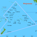
The Oceania PortalOceania (UK: /ˌoʊsiˈɑːniə, ˌoʊʃi-, -ˈeɪn-/ OH-s(h)ee-AH-nee-ə, -AY-, US: /ˌoʊʃiˈæniə, -ˈɑːn-/ OH-shee-A(H)N-ee-ə) is a geographical region including Australasia, Melanesia, Micronesia, and Polynesia. Outside of the English-speaking world, Oceania is generally considered a continent, while Mainland Australia is regarded as its continental landmass. Spanning the Eastern and Western hemispheres, at the centre of the water hemisphere, Oceania is estimated to have a land area of about 9,000,000 square kilometres (3,500,000 sq mi) and a population of around 44.4 million as of 2022. Oceania is the smallest continent in land area and the second-least populated after Antarctica. Oceania has a diverse mix of economies from the highly developed and globally competitive financial markets of Australia, French Polynesia, Hawaii, New Caledonia, and New Zealand, which rank high in quality of life and Human Development Index, to the much less developed economies of Kiribati, Papua New Guinea, Tuvalu, Vanuatu, and Western New Guinea. The largest and most populous country in Oceania is Australia, and the largest city is Sydney. Puncak Jaya in Indonesia is the highest peak in Oceania at 4,884 m (16,024 ft). The rock art of Aboriginal Australians is the longest continuously practiced artistic tradition in the world. Most Oceanian countries are parliamentary democracies, with tourism serving as a large source of income for the Pacific island nations. (Full article...) Selected geographic article - Guam (/ˈɡwɑːm/ GWAHM; Chamorro: Guåhan [ˈɡʷɑhɑn]) is an organized, unincorporated territory of the United States in the Micronesia subregion of the western Pacific Ocean. Guam's capital is Hagåtña, and the most populous village is Dededo. It is the westernmost point and territory of the United States, reckoned from the geographic center of the U.S. In Oceania, Guam is the largest and southernmost of the Mariana Islands and the largest island in Micronesia. As of 2022, its population was 168,801. Chamorros are its largest ethnic group, but a minority on the multiethnic island. The territory spans 210 square miles (540 km2; 130,000 acres) and has a population density of 775 per square mile (299/km2). Indigenous Guamanians are the Chamorro, who are related to the Austronesian peoples of the Malay Archipelago, the Philippines, Taiwan, and Polynesia. But unlike most of its neighbors, the Chamorro language is not classified as a Micronesian or Polynesian language. Rather, like Palauan, it possibly constitutes an independent branch of the Malayo-Polynesian language family. The Chamorro people settled Guam and the Mariana islands approximately 3,500 years ago. Portuguese explorer Ferdinand Magellan, while in the service of Spain, was the first European to visit and claim the island on March 6, 1521. Guam was fully colonized by Spain in 1668. Between the 16th and 18th centuries, Guam was an important stopover for Spanish Manila galleons. During the Spanish–American War, the United States captured Guam on June 21, 1898. Under the 1898 Treaty of Paris, Spain ceded Guam to the U.S. effective April 11, 1899. (Full article...) Related portalsSelected article -Hōkūleʻa is a performance-accurate waʻa kaulua, a Polynesian double-hulled voyaging canoe. Launched on 8 March 1975 by the Polynesian Voyaging Society, it is best known for its 1976 Hawaiʻi to Tahiti voyage completed with exclusively traditional navigation techniques. The primary goal of the voyage was to explore the anthropological theory of the Asiatic origin of native Oceanic people (Polynesians and Hawaiians in particular) as the result of purposeful trips through the Pacific, as opposed to passive drifting on currents or sailing from the Americas. DNA analysis supports this theory. A secondary project goal was to have the canoe and voyage "serve as vehicles for the cultural revitalization of Hawaiians and other Polynesians." Between the 1976 voyage and 2009, Hōkūle‘a completed nine[update] additional voyages to Micronesia, Polynesia, Japan, Canada and the mainland United States, all using ancient wayfinding techniques of celestial navigation. On 19 January 2007, Hōkūle‘a left Hawaiʻi with the voyaging canoe Alingano Maisu on a voyage through Micronesia (map) and ports in southern Japan.[a] The voyage was expected to take five months. On 9 June 2007, Hōkūle‘a completed the "One Ocean, One People" voyage to Yokohama, Japan. On 5 April 2009, Hōkūle‘a returned to Honolulu following a roundtrip training sail to Palmyra Atoll, undertaken to develop skills of potential crewmembers for Hōkūle‘a's eventual circumnavigation of the Earth. (Full article...) Did you know -
General images -The following are images from various Oceania-related articles on Wikipedia.
TopicsSubcategoriesThings you can doAssociated WikimediaThe following Wikimedia Foundation sister projects provide more on this subject:
In other languagesWikipedia in other languages used in Oceania:
More portals |


