
Portal:World
The World Portal


The world is the totality of entities, the whole of reality, or everything that exists. The nature of the world has been conceptualized differently in different fields. Some conceptions see the world as unique, while others talk of a "plurality of worlds". Some treat the world as one simple object, while others analyze the world as a complex made up of parts.
In scientific cosmology, the world or universe is commonly defined as "the totality of all space and time; all that is, has been, and will be". Theories of modality talk of possible worlds as complete and consistent ways how things could have been. Phenomenology, starting from the horizon of co-given objects present in the periphery of every experience, defines the world as the biggest horizon, or the "horizon of all horizons". In philosophy of mind, the world is contrasted with the mind as that which is represented by the mind.
Theology conceptualizes the world in relation to God, for example, as God's creation, as identical to God, or as the two being interdependent. In religions, there is a tendency to downgrade the material or sensory world in favor of a spiritual world to be sought through religious practice. A comprehensive representation of the world and our place in it, as is found in religions, is known as a worldview. Cosmogony is the field that studies the origin or creation of the world, while eschatology refers to the science or doctrine of the last things or of the end of the world.
In various contexts, the term "world" takes a more restricted meaning associated, for example, with the Earth and all life on it, with humanity as a whole, or with an international or intercontinental scope. In this sense, world history refers to the history of humanity as a whole, and world politics is the discipline of political science studying issues that transcend nations and continents. Other examples include terms such as "world religion", "world language", "world government", "world war", "world population", "world economy", or "world championship". (Full article...)
Selected articles -
-
 The Special Report on Global Warming of 1.5 °C (SR15) was published by the Intergovernmental Panel on Climate Change (IPCC) on 8 October 2018. The report, approved in Incheon, South Korea, includes over 6,000 scientific references, and was prepared by 91 authors from 40 countries. In December 2015, the 2015 United Nations Climate Change Conference called for the report. The report was delivered at the United Nations' 48th session of the IPCC to "deliver the authoritative, scientific guide for governments" to deal with climate change. Its key finding is that meeting a 1.5 °C (2.7 °F) target is possible but would require "deep emissions reductions" and "rapid, far-reaching and unprecedented changes in all aspects of society". Furthermore, the report finds that "limiting global warming to 1.5 °C compared with 2 °C would reduce challenging impacts on ecosystems, human health and well-being" and that a 2 °C temperature increase would exacerbate extreme weather, rising sea levels and diminishing Arctic sea ice, coral bleaching, and loss of ecosystems, among other impacts.
SR15 also has modelling that shows that, for global warming to be limited to 1.5 °C, "Global net human-caused emissions of carbon dioxide (CO2) would need to fall by about 45 percent from 2010 levels by 2030, reaching 'net zero' around 2050." The reduction of emissions by 2030 and its associated changes and challenges, including rapid decarbonisation, was a key focus on much of the reporting which was repeated through the world. (Full article...) -

Artist's impression of a major asteroid impact. An asteroid caused the extinction of the non-avian dinosaurs.
A global catastrophic risk or a doomsday scenario is a hypothetical event that could damage human well-being on a global scale, even endangering or destroying modern civilization. An event that could cause human extinction or permanently and drastically curtail humanity's existence or potential is known as an "existential risk".
In the 21st century, a number of academic and non-profit organizations have been established to research global catastrophic and existential risks, formulate potential mitigation measures and either advocate for or implement these measures. (Full article...) -

The astronomical symbol of Earth represents either the four quadrants of the world or the four continents.
Several cosmological and mythological systems portray four corners of the world or four quarters of the world corresponding approximately to the four points of the compass (or the two solstices and two equinoxes). At the center may lie a sacred mountain, garden, world tree, or other beginning-point of creation. Often four rivers run to the four corners of the world, and water or irrigate the four quadrants of Earth. (Full article...) -
The global digital divide describes global disparities, primarily between developed and developing countries, in regards to access to computing and information resources such as the Internet and the opportunities derived from such access.
The Internet is expanding very quickly, and not all countries—especially developing countries—can keep up with the constant changes.[example needed] The term "digital divide" does not necessarily mean that someone does not have technology; it could mean that there is simply a difference in technology. These differences can refer to, for example, high-quality computers, fast Internet, technical assistance, or telephone services. (Full article...) -

Plates in the crust of Earth
Earth's crust is its thick outer shell of rock, referring to less than one percent of the planet's radius and volume. It is the top component of the lithosphere, a solidified division of Earth's layers that includes the crust and the upper part of the mantle. The lithosphere is broken into tectonic plates whose motion allows heat to escape the interior of Earth into space.
The crust lies on top of the mantle, a configuration that is stable because the upper mantle is made of peridotite and is therefore significantly denser than the crust. The boundary between the crust and mantle is conventionally placed at the Mohorovičić discontinuity, a boundary defined by a contrast in seismic velocity. (Full article...) -

The Egyptian–Hittite peace treaty, on display at the Istanbul Archaeology Museum, was for a long time believed to be the earliest example of any written international agreement of any kind.
A treaty is a formal, legally binding written agreement between sovereign states and/or international organizations that is governed by international law. A treaty may also be known as an international agreement, protocol, covenant, convention, pact, or exchange of letters, among other terms; however, only documents that are legally binding on the parties are considered treaties under international law. Treaties may be bilateral (between two countries) or multilateral (involving more than two countries).
Treaties are among the earliest manifestations of international relations; the first known example is a border agreement between the Sumerian city-states of Lagash and Umma around 3100 BC. International agreements were used in some form by most major civilizations and became increasingly common and more sophisticated during the early modern era. The early 19th century saw developments in diplomacy, foreign policy, and international law reflected by the widespread use of treaties. The 1969 Vienna Convention on the Law of Treaties (VCLT) codified these practices and established rules and guidelines for creating, amending, interpreting, and terminating treaties, and for resolving disputes and alleged breaches. (Full article...) -

High, medium, and low projections of the future human world population
In world demographics, the world population is the total number of humans currently alive. It was estimated by the United Nations to have exceeded eight billion in mid-November 2022. It took around 300,000 years of human prehistory and history for the human population to reach a billion and only 218 more years to reach 8 billion.
The human population has experienced continuous growth following the Great Famine of 1315–1317 and the end of the Black Death in 1350, when it was nearly 370,000,000. The highest global population growth rates, with increases of over 1.8% per year, occurred between 1955 and 1975, peaking at 2.1% between 1965 and 1970. The growth rate declined to 1.1% between 2015 and 2020 and is projected to decline further in the 21st century. The global population is still increasing, but there is significant uncertainty about its long-term trajectory due to changing fertility and mortality rates. The UN Department of Economics and Social Affairs projects between 9 and 10 billion people by 2050 and gives an 80% confidence interval of 10–12 billion by the end of the 21st century, with a growth rate by then of zero. Other demographers predict that the human population will begin to decline in the second half of the 21st century. (Full article...)


.svg)


General images -
-
 13th-century French historiated initial with the three classes of medieval society: those who prayed (the clergy), those who fought (the knights), and those who worked (the peasantry)
 -
 Japanese depiction of a Portuguese carrack, a result of globalizing maritime trade
 -
 A 2012 artistic impression of the early Solar System's protoplanetary disk from which Earth and other Solar System bodies were formed (from Earth)
 -

-

-
 An artist's impression of the Archean, the eon after Earth's formation, featuring round stromatolites, which are early oxygen-producing forms of life from billions of years ago. After the Late Heavy Bombardment, Earth's crust had cooled, its water-rich barren surface is marked by continents and volcanoes, with the Moon still orbiting Earth half as far as it is today, appearing 2.8 times larger and producing strong tides. (from Earth)
 -
 Chennakesava Temple, Belur, India
 -
 Cuneiform inscription, eastern Turkey
 -
 An artist's impression of ice age Earth at glacial maximum. (from History of Earth)
 -
 A computer-generated image mapping the prevalence of artificial satellites and space debris around Earth in geosynchronous and low Earth orbit (from Earth)
 -
 Model of a Australopithecus afarensis at the Smithsonian National Museum of Natural History. This reconstruction depicts the facultative bipedalism hypothesis, indicated by the use of the tree for stabilization. (from Human history)
 -
 A reconstruction of human history based on fossil data. (from History of Earth)
 -
 A composite image of Earth, with its different types of surface discernible: Earth's surface dominating Ocean (blue), Africa with lush (green) to dry (brown) land and Earth's polar ice in the form of Antarctic sea ice (grey) covering the Antarctic or Southern Ocean and the Antarctic ice sheet (white) covering Antarctica. (from Earth)
 -
 Benin Bronze head from Nigeria
 -
 Earth's axial tilt causing different angles of seasonal illumination at different orbital positions around the Sun (from Earth)
 -
 A view of Earth with its global ocean and cloud cover, which dominate Earth's surface and hydrosphere; at Earth's polar regions, its hydrosphere forms larger areas of ice cover. (from Earth)
 -
 An animation of the changing density of productive vegetation on land (low in brown; heavy in dark green) and phytoplankton at the ocean surface (low in purple; high in yellow) (from Earth)
 -
 Last Moon landing: Apollo 17 (1972)
 -
 Dinosaurs were the dominant terrestrial vertebrates throughout most of the Mesozoic (from History of Earth)
 -
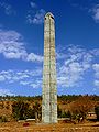 Obelisk of Axum, Ethiopia
 -

-
 A 580 million year old fossil of Spriggina floundensi, an animal from the Ediacaran period. Such life forms could have been ancestors to the many new forms that originated in the Cambrian Explosion. (from History of Earth)
 -
 Image of the physical world, captured by the Hubble Space Telescope (from World)
 -
 Battle during the 1281 Mongol invasion of Japan
 -
 The first airplane, the Wright Flyer, flew on 17 December 1903.
 -
 European migrations by mostly Germanic peoples, 2nd–6th centuries (from Human history)
 -
 The replicator in virtually all known life is deoxyribonucleic acid. DNA is far more complex than the original replicator and its replication systems are highly elaborate. (from History of Earth)
 -
 Artist's impression of the enormous collision that probably formed the Moon (from History of Earth)
 -
 A view of Earth with different layers of its atmosphere visible: the troposphere with its clouds casting shadows, a band of stratospheric blue sky at the horizon, and a line of green airglow of the lower thermosphere around an altitude of 100 km, at the edge of space (from Earth)
 -
 A schematic view of Earth's magnetosphere with solar wind flowing from left to right (from Earth)
 -
 A map of heat flow from Earth's interior to the surface of Earth's crust, mostly along the oceanic ridges (from Earth)
 -
 Pangaea was a supercontinent that existed from about 300 to 180 Ma. The outlines of the modern continents and other landmasses are indicated on this map. (from History of Earth)
 -
 Standing Buddha from Gandhara, 2nd century CE
 -
 Artist's rendition of an oxinated fully-frozen Snowball Earth with no remaining liquid surface water. (from History of Earth)
 -
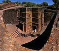 One of the eleven Rock-hewn Churches of Lalibela constructed during the Zagwe dynasty in Ethiopia (from Human history)
 -
 Fall of the Berlin Wall, 1989
 -
 Earth's land use for human agriculture in 2019 (from Earth)
 -
 Empires of the world in 1898
 -
 A pillar at Neolithic Göbekli Tepe
 -
 Tracy Caldwell Dyson, a NASA astronaut, observing Earth from the Cupola module at the International Space Station on 11 September 2010 (from Earth)
 -
 Olmec colossal head, now at the Museo de Antropología de Xalapa
 -
 Shanghai. China urbanized rapidly in the 21st century.
 -
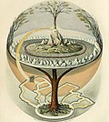 Yggdrasil, an attempt to reconstruct the Norse world tree which connects the heavens, the world, and the underworld. (from World)
 -
 Ming dynasty section, Great Wall of China
 -

-
 Great Pyramids of Giza, Egypt
 -
 An artist's rendering of a protoplanetary disk (from History of Earth)
 -
 Graph showing range of estimated partial pressure of atmospheric oxygen through geologic time (from History of Earth)
 -
 Geologic map of North America, color-coded by age. From most recent to oldest, age is indicated by yellow, green, blue, and red. The reds and pinks indicate rock from the Archean.
 -
 Machu Picchu, Inca Empire, Peru
 -
 Successive dispersals of Homo erectus (yellow), Homo neanderthalensis (ochre) during Out of Africa I and Homo sapiens (red, Out of Africa II), with the numbers of years since they appeared before present. (from Human history)
 -
 Tiktaalik, a fish with limb-like fins and a predecessor of tetrapods. Reconstruction from fossils about 375 million years old. (from History of Earth)
 -
 Chloroplasts in the cells of a moss (from History of Earth)
 -
 Portrait of Alfraganus in the Compilatio astronomica, 1493. Islamic astronomers began just before the 9th century to collect and translate Indian, Persian and Greek astronomical texts, adding their own astronomy and enabling later, particularly European astronomy to build on. Symbolic for the post-classical period, a period of an increasing trans-regional literary culture, particularly in the sciences, spreading and building on methods of science. (from Human history)
 -
 Notre-Dame de Paris, France
 -
 The pale orange dot, an artist's impression of the early Earth which might have appeared orange through its hazy methane rich prebiotic second atmosphere. Earth's atmosphere at this stage was somewhat comparable to today's atmosphere of Titan. (from History of Earth)
 -
Pale orange dot, an artist's impression of Early Earth, featuring its tinted orange methane-rich early atmosphere (from Earth)
-

-
 Change in average surface air temperature and drivers for that change. Human activity has caused increased temperatures, with natural forces adding some variability. (from Earth)
 -

-
 Artist's impression of a Hadean landscape with the relatively newly formed Moon still looming closely over Earth and both bodies sustaining strong volcanism. (from History of Earth)
 -
 Taj Mahal, Mughal Empire, India
 -
 Cross-section through a liposome (from History of Earth)
 -
 Earth's night-side upper atmosphere appearing from the bottom as bands of afterglow illuminating the troposphere in orange with silhouettes of clouds, and the stratosphere in white and blue. Next the mesosphere (pink area) extends to the orange and faintly green line of the lowest airglow, at about one hundred kilometers at the edge of space and the lower edge of the thermosphere (invisible). Continuing with green and red bands of aurorae stretching over several hundred kilometers. (from Earth)
 -
 Earth's history with time-spans of the eons to scale. Ma means "million years ago". (from History of Earth)
 -
 Earth's western hemisphere showing topography relative to Earth's center instead of to mean sea level, as in common topographic maps (from Earth)
 -
 Pillar erected by Ashoka, a Mauryan Emperor in India
 -
 Artist's conception of Hadean Eon Earth, when it was much hotter and inhospitable to all forms of life. (from History of Earth)
 -

-
 A composite image of artificial light emissions at night on a map of Earth (from Earth)
 -
 Lithified stromatolites on the shores of Lake Thetis, Western Australia. Archean stromatolites are the first direct fossil traces of life on Earth. (from History of Earth)
 -

-

-
 Vitruvian Man by Leonardo da Vinci epitomizes the advances in art and science seen during the Renaissance. (from History of Earth)
 -

-

-
 A banded iron formation from the 3.15 Ga Moodies Group, Barberton Greenstone Belt, South Africa. Red layers represent the times when oxygen was available; gray layers were formed in anoxic circumstances. (from History of Earth)
 -
 Florence, birthplace of the Italian Renaissance
 -
 A reconstruction of Pannotia (550 Ma). (from History of Earth)
 -
 Angkor Wat temple complex, Cambodia, early 12th century
 -
 Artist's conception of Devonian flora (from History of Earth)
 -
Artist's impression of Earth during the later Archean, the largely cooled planetary crust and water-rich barren surface, marked by volcanoes and continents, features already round microbialites. The Moon, still orbiting Earth much closer than today and still dominating Earth's sky, produced strong tides. (from History of Earth)
-
 COVID-19 pandemic, 2020 (from Human history)
 -
 Trilobites first appeared during the Cambrian period and were among the most widespread and diverse groups of Paleozoic organisms. (from History of Earth)
 -
 Carving of Persian and Median soldiers, Persepolis, Achaemenid Empire, 5th century BCE
 -

-

-
 Satellite time lapse imagery of Earth's rotation showing axis tilt (from Earth)


.png)


.jpg)


.jpeg)


.svg)


.jpg)


Megacities of the world -

Delhi, officially the National Capital Territory (NCT) of Delhi, is a city and a union territory of India containing New Delhi, the capital of India. Straddling the Yamuna river, but spread chiefly to the west, or beyond its right bank, Delhi shares borders with the state of Uttar Pradesh in the east and with the state of Haryana in the remaining directions. Delhi became a union territory on 1 November 1956 and the NCT in 1995. The NCT covers an area of 1,484 square kilometres (573 sq mi). According to the 2011 census, Delhi's city proper population was over 11 million, while the NCT's population was about 16.8 million.
The topography of the medieval fort Purana Qila on the banks of the river Yamuna matches the literary description of the citadel Indraprastha in the Sanskrit epic Mahabharata; however, excavations in the area have revealed no signs of an ancient built environment. From the early 13th century until the mid-19th century, Delhi was the capital of two major empires, the Delhi Sultanate and the Mughal Empire, which covered large parts of South Asia. All three UNESCO World Heritage Sites in the city, the Qutub Minar, Humayun's Tomb, and the Red Fort, belong to this period. Delhi was the early centre of Sufism and Qawwali music. The names of Nizamuddin Auliya and Amir Khusrau are prominently associated with it. The Khariboli dialect of Delhi was part of a linguistic development that gave rise to the literature of Urdu and later Modern Standard Hindi. Major Urdu poets from Delhi include Mir Taqi Mir and Mirza Ghalib. Delhi was a notable centre of the Indian Rebellion of 1857. In 1911, New Delhi, a southern region within Delhi, became the capital of the British Indian Empire. During the Partition of India in 1947, Delhi was transformed from a Mughal city to a Punjabi one, losing two-thirds of its Muslim residents, in part due to the pressure brought to bear by arriving Hindu and Sikh refugees from western Punjab. After independence in 1947, New Delhi continued as the capital of the Dominion of India, and after 1950 of the Republic of India. (Full article...)
Did you know -

- ... that the ceramicist Sandy Brown wanted her sculpture Earth Goddess to be "female and making an impact"?
- ... that Alfred Egerton Cooper, a war artist who lost the use of an eye in World War I, painted airships?
- ... that Taylor Swift said that her first live album, Speak Now World Tour – Live, was meant to capture what she wanted to "show [...] my kids and my grandkids"?
- ... that Oleksandr Kamyshin, the head of Ukrainian Railways, who runs the iron diplomacy program that brings world leaders to Kyiv by rail, carries his gun and his son's stuffed owl with him?
- ... that Derrick Palmer and Chris Smalls, leaders of the Amazon Labor Union, were named two of the "100 most influential people in the world" in 2022?
- ... that the botanist Victor Jacob Koningsberger spoke out against the expulsion of Jewish academics in the occupied Netherlands?
- ... that Aldous Huxley developed his "feelies" in response to the emergence of "talkies"?
- ... that Chronicles from the Land of the Happiest People on Earth was Wole Soyinka's first novel in nearly fifty years?
Countries of the world -

Oman, officially the Sultanate of Oman, is a country located on the southeastern coast of the Arabian Peninsula in West Asia and the Middle East. It shares land borders with Saudi Arabia, the United Arab Emirates, and Yemen. The capital and largest city is Muscat. As of 2024, Oman has a population of approximately 5.28 million, reflecting a 4.60% population increase from 2023. It is the 123rd most-populous country.
Oman’s coastline faces the Arabian Sea to the southeast and the Gulf of Oman on the northeast. The Madha and Musandam exclaves are surrounded by the United Arab Emirates on their land borders, while Musandam’s coastal boundaries are formed by the Strait of Hormuz (which it shares with Iran) and the Gulf of Oman. (Full article...)
The 12 Treasures of Spain (Spanish: 12 Tesoros de España) was a project that selected the purported "Twelve Treasures of the Kingdom of Spain". The contest was conducted by broadcasters Antena 3 and COPE. The final results were announced on 31 December 2007. Nine architectural monuments, two natural monuments and a monument pictorial were chosen. (Full article...)
Related portals
Protected areas of the world -
-
Upolu Island, Samoa
This is a list of some protected areas of Samoa which include national parks, reservations, protected nature zones, marine reserves and other areas of significant biodiversity and conservation.
In 1994, Samoa ratified the international and legally binding treaty, the Convention on Biological Diversity to develop national strategies for conservation and sustainable use of biological diversity. In 2010, protected areas in the country cover 5% of land although the government aims to increase protected areas coverage to 15%. (Full article...) -
Bihar is a state in East India. It is bounded by Uttar Pradesh to the west, Nepal to the north, West Bengal to the east and Jharkhand to the south. About 7% of the state is protected forest area. (Full article...)
-
This is a list of protected areas of Yukon. The Yukon, formerly called Yukon Territory and sometimes referred to as just Yukon is the smallest and westernmost of Canada's three territories. It also is the least populated province or territory in Canada, with a population of 35,874 people as of the 2016 Census. (Full article...) -

Cranes at Sevan National Park
This is a list of protected areas in Armenia that are categorized as follows: 4 national parks, 3 state reserves, 27 state sanctuaries and 5 botanical gardens. The percentage of protected land in Armenia is approximately 12.89% (2309.0853 km² 891.542819 sq mi). (Full article...) -
Queensland is the second-largest state in Australia. As at 2020, it contained more than 1,000 protected areas. In August 2023, it was estimated a total of 14.5 million hectares or 8.38% of Queensland's landmass was protected. (Full article...)
-

Centre for Nature Education at the Białowieża National Park, Poland
Protected areas of Poland include the following categories, as defined by the Act on Protection of Nature (Polish: Ustawa o ochronie przyrody) of 16 April 2004, by the Polish Parliament: (Full article...) -
Protected areas in the U.S. State of Ohio include national forest lands, Army Corps of Engineers areas, state parks, state forests, state nature preserves, state wildlife management areas, and other areas. (Full article...)
-
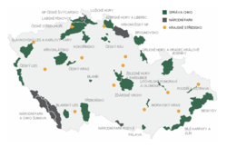
Map of protected areas of the Czech Republic: national parks (grey) and protected landscape areas (green)
There are several types of protected areas of the Czech Republic. The main form of landscape protection is delimitation of special protected areas. All the types of protected areas are determined by law. (Full article...) -
Illinois has a variety of protected areas, including over 123 state-protected areas, dozens of federally protected areas, hundreds of county-level and municipal park areas. Illinois also contains sites designated as internationally important protected areas. These multiple levels of protection contribute to a statewide network of numerous recreation opportunities and conservation schemes, sometimes in a small area. For example, DeKalb County contains a 1,000-acre (4.0 km2) forest preserve system and a 1,500-acre (6.1 km2) state park (Shabbona Lake State Park); within DeKalb County, the DeKalb Park District in the City of DeKalb has a 700-acre (2.8 km2) park system. (Full article...)
-
-
Kentucky's system of 44 state parks has been referred to as "the nation's finest" and experiences more repeat business annually than those of any other U.S. state. The state's diverse geography provides a variety of environments to experience. From mountain lakes to expansive caves to forests teeming with wildlife, park-goers have their choice of attractions, and they are all within a day's drive of each other.
Unless otherwise specified, data in the following lists are taken from Kentucky State Parks by Bill Bailey. (Full article...) -
Protected areas of Tasmania consist of protected areas located within Tasmania and its immediate onshore waters, including Macquarie Island. It includes areas of crown land (withheld land) managed by Tasmanian Government agencies as well as private reserves. As of 2016, 52% of Tasmania's land area has some form of reservation classification, the majority is managed by the Tasmania Parks & Wildlife Service (about 42% of total Tasmanian land area). Marine protected areas cover about 7.9% of state waters.
Within each classification of reserve there may be a variation of IUCN categories Australia is a signatory to the Convention of Biological Diversity and as such has obligations to report the status of its National Reserve System.IUCN provides on its website a prescription for activities consistent with the categorisation system. Changes made to the Nature Conservation Act 2002 in 2014 permit timber harvesting. These changes made in addition to the already established right to access minerals means that many of the IUCN categorisations assigned to individual reserves in Tasmania are no longer fit for purpose. In addition many reserves have had their reserve status downgraded from a class excluding timber harvesting and mineral extraction to ones where these activities are now permitted. This mis-application of the IUCN protected area categories needs to be remedied or the reserves protected land class under the Nature Conservation Act 2002 should be adjusted to reflect its currently assigned IUCN category. (Full article...) -
The Australian Capital Territory as of 2014 contains 46 separate protected areas with a total land area of 1,302 km2 (503 sq mi) or 55.5% of the territory's area, and which managed by Territory and Municipal Services of the ACT government: (Full article...)
-
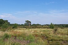
Heathland at the Hoge Kempen National Park
There are numerous protected areas in Belgium with a wide variety of types, protection levels and sizes. The below list gives an overview of the most important protected areas. (Full article...) -

The sun over the Lake Niassa Reserve
Protected areas in Mozambique are known as conservation areas, and are currently grouped into national parks, national reserves, forest reserves, wildlife utilisation areas (coutadas), community conservation areas, and private game farms (fazendas de bravio). There are also a number of areas that have been declared as protected areas under a variety of different legislation, which for reasons of simplicity are here grouped together as "other protected areas." Under the Conservation Law of 2014 (Law 16/2014 of June 20), protected areas will need to be reclassified into a much more flexible series of new categories which are closer to the international system used by the IUCN. International initiatives such as transfrontier parks are grouped at the end of the page. (Full article...)


.jpg)
Selected world maps
-
 A plate tectonics map with volcano locations indicated with red circles
 -
 United Nations Human Development Index map by country (2016)
 -
 Mollweide projection of the world
 -
 Index map from the International Map of the World (1:1,000,000 scale)
 -
 The world map by Gerardus Mercator (1569), the first map in the well-known Mercator projection
 -
 The Goode homolosine projection is a pseudocylindrical, equal-area, composite map projection used for world maps.
 -
 Time zones of the world
 -
 1516 map of the world by Martin Waldseemüller
 -
 Only a few of the largest large igneous provinces appear (coloured dark purple) on this geological map, which depicts crustal geologic provinces as seen in seismic refraction data


World records
- List of Olympic records in athletics
- List of world records in athletics
- List of junior world records in athletics
- List of world records in masters athletics
- List of world youth bests in athletics
- List of IPC world records in athletics
- List of world records in canoeing
- List of world records in chess
- List of cycling records
- List of world records in track cycling
- List of world records in finswimming
- List of world records in juggling
- List of world records in rowing
- List of world records in speed skating
- List of world records in swimming
- List of IPC world records in swimming
- List of world records in Olympic weightlifting
Topics

Continents of Earth | ||||||||
|---|---|---|---|---|---|---|---|---|
| ||||||||
| ||||||||
| ||||||||


| Cenozoic Era (present–66.0 Ma) |
| ||||||||||||
|---|---|---|---|---|---|---|---|---|---|---|---|---|---|
| Mesozoic Era (66.0–252 Ma) |
| ||||||||||||
| Paleozoic Era (252–539 Ma) |
| ||||||||||||
| Proterozoic Eon (539 Ma–2.5 Ga) |
| ||||||||||||
| Archean Eon (2.5–4 Ga) | |||||||||||||
| Hadean Eon (4–4.6 Ga) | |||||||||||||
ka = kiloannum (thousand years ago); Ma = megaannum (million years ago); Ga = gigaannum (billion years ago). See also: Geologic time scale • | |||||||||||||
| Locations | ||
|---|---|---|
| Related | ||

| |||||||||||||||||||
| |||||||||||||||||||
| |||||||||||||||||||
Economic classification of countries | |||||
|---|---|---|---|---|---|
| Three-World Model | |||||
| Gross domestic product (GDP) |
| ||||
| Gross national income (GNI) | |||||
| Wages | |||||
| Wealth | |||||
| Other national accounts | |||||
| Human development | |||||
| Digital divide | |||||
| Net international investment position (NIIP) | |||||
| Technological |
| ||||
|---|---|---|---|---|---|
| Sociological | |||||
| Ecological |
| ||||
| Biological |
| ||||
| Astronomical | |||||
| Eschatological |
| ||||
| Others |
| ||||
| Fictional | |||||
| Organizations | |||||
Categories

Wikimedia
The following Wikimedia Foundation sister projects provide more on this subject:
-
 Commons
Free media repository -
 Wikibooks
Free textbooks and manuals -
 Wikidata
Free knowledge base -
 Wikinews
Free-content news -
 Wikiquote
Collection of quotations -
 Wikisource
Free-content library -
 Wikispecies
Directory of species -
 Wikiversity
Free learning tools -
 Wikivoyage
Free travel guide -
 Wiktionary
Dictionary and thesaurus


