
Portal:Myanmar
ကြိုဆိုပါတယ်။ / Welcome to the Myanmar Portal 

Myanmar, officially the Republic of the Union of Myanmar and also rendered Burma (the official English form until 1989), is a country in northwest Southeast Asia. It is the largest country by area in Mainland Southeast Asia and has a population of about 55 million. It is bordered by India to its west, Bangladesh to its southwest, China to its northeast, Laos and Thailand to its east and southeast, and the Andaman Sea and the Bay of Bengal to its south and southwest. The country's capital city is Naypyidaw, and its largest city is Yangon (formerly Rangoon).
Myanmar is a member of the East Asia Summit, Non-Aligned Movement, ASEAN, and BIMSTEC, but it is not a member of the Commonwealth of Nations despite once being part of the British Empire. Myanmar is a Dialogue Partner of the Shanghai Cooperation Organization. The country is very rich in natural resources, such as jade, gems, oil, natural gas, teak and other minerals, as well as also endowed with renewable energy, having the highest solar power potential compared to other countries of the Great Mekong Subregion. However, Myanmar has long suffered from instability, factional violence, corruption, poor infrastructure, as well as a long history of colonial exploitation with little regard to human development. In 2013, its GDP (nominal) stood at US$56.7 billion and its GDP (PPP) at US$221.5 billion. The income gap in Myanmar is among the widest in the world, as a large proportion of the economy is controlled by cronies of the military junta. Myanmar is one of the least developed countries; as of 2020, according to the Human Development Index, it ranks 147 out of 189 countries in terms of human development, the lowest in Southeast Asia. Since 2021, more than 600,000 people were displaced across Myanmar due to the surge in violence post-coup, with more than 3 million people in dire need of humanitarian assistance. (Full article...)
Selected articles -
-

Yenangyaung (Burmese: ရေနံချောင်း; literally "stream of oil") is a city in the Magway Region of central Myanmar, located on the Irrawaddy River and 363 miles from Yangon. Until 1974, it remained the capital city of both Minbu Division (now Magway Division) and Yenangyaung District. The population of Yenanchaung was 45,120 according to the 2014 census, but it reached 49,938 in September 2020. This makes it the fourth-largest city in the Magway Region, after Pakokku, Magway and Aunglan. General Aung San received his secondary education in this city. (Full article...) -
Myanmar is divided into 21 administrative divisions, which include seven regions, seven states, one union territory, one self-administered division, and five self-administered zones. (Full article...)
-
The 2010–2012 Myanmar border clashes were a series of skirmishes between the Tatmadaw (Myanmar Armed Forces) on one side, and the DKBA-5 and the Karen National Liberation Army (KNLA) on the other. The clashes erupted along the border with Thailand shortly after Myanmar's general election on 7 November 2010. An estimated 10,000 refugees have fled into nearby neighbouring Thailand to escape the violent conflict. There was concern that due to discontent with the elections, and speculations of electoral fraud, that the conflict could escalate into a civil war. (Full article...)
-
The Kingdom of Ava (Burmese: အင်းဝခေတ်, pronounced [ʔɪ́ɰ̃wa̰ kʰɪʔ]; INN-wa khit) was the dominant kingdom that ruled upper Burma (Myanmar) from 1365 to 1555. Founded in 1365, the kingdom was the successor state to the petty kingdoms of Myinsaing, Pinya and Sagaing that had ruled central Burma since the collapse of the Pagan Empire in the late 13th century.
Like the small kingdoms that preceded it, Ava may have been led by Bamarised Shan kings who claimed descent from the kings of Pagan. Scholars debate that the Shan ethnicity of Avan kings comes from mistranslation, particularly from a record of the Avan kings' ancestors ruling a Shan village in central Burma prior to their rise or prominence. (Full article...) -
The Saffron Revolution (Burmese: ရွှေဝါရောင်တော်လှန်ရေး) was a series of economic and political protests and demonstrations that took place during August, September, and October 2007 in Myanmar. The protests were triggered by the decision of the national military government to remove subsidies on the sales prices of fuel. The national government is the only supplier of fuels and the removal of the price subsidy immediately caused diesel and petrol prices to increase by 66–100% and the price of compressed natural gas for buses to increase 500% in less than a week.
The various protests were led by students, political activists, including women, and Buddhist monks and took the form of a campaign of nonviolent resistance, sometimes also called civil resistance. (Full article...) -
Censorship in Myanmar (also called Burma) results from government policies in controlling and regulating certain information, particularly on religious, ethnic, political, and moral grounds.
Freedom of speech and the press are not guaranteed by law. Many colonial-era laws regulating the press and information continue to be used. Until August 2012, every publication (including newspaper articles, cartoons, advertisements, and illustrations) required pre-approval by the Press Scrutiny and Registration Division (PSRB) of the Ministry of Information. However, the 2011–2012 Burmese political reforms signalled significant relaxations of the country's censorship policies and in August 2012 the Ministry of Information lifted the requirement that print media organisations submit materials to the government prior to publication. (Full article...) -
Gadaw (Burmese: ကန်တော့, IPA: [ɡədɔ̰]; also spelt kadaw) is a Burmese verb referring to a Burmese tradition in which a person, always of lower social standing, pays respect or homage to a person of higher standing (including Buddhist monks, elders, teachers and Buddha), by kneeling before them and paying obeisance with joined hands, and bowing. This is usually done by students to their teachers or children or grandchildren to their elders (parents, aunts, uncles and grandparents), in order to show gratitude and reverence and an opportunity to ask for forgiveness, often involving gift-giving.
It is traditionally done on New Year's Day of Thingyan and during the month of Thadingyut (roughly October), which marks the end of Vassa, the Buddhist lent. (Full article...) -
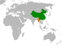
China–Myanmar relations (Chinese: 中缅关系; Burmese: တရုတ်မြန်မာဆက်ဆံရေး) are the international relations between the People's Republic of China and Myanmar. China and Myanmar have active bilateral relations with each other. The relation is often described as a pauk-phaw relationship (Burmese: ပေါက်ဖော်), based a Burmese term for kinsfolk that implicates special asymmetric obligations between the two countries.
Generally, China has maintained positive relationships with both military and elected governments in Myanmar. In recent years, bilateral relations between China and the current Myanmar government (Junta) have faced difficulties due to alleged Chinese backing of rebels in Myanmar's territories. In recent years, the relations between China and Myanmar have faced some problems due to ongoing clashes between ethnic Chinese rebels and the Myanmar military near the China–Myanmar border. (Full article...) -

Thura Ma Chit Po (Burmese: သူရ မချစ်ပို; February 1908 – 8 April 1949) was a Burmese woman who was the one and only civilian woman to have received the Thura medal for bravery. She gathered intelligence on the Karen National Defence Organisation (KNDO) on behalf of the Myanmar Military before she was caught and executed by the KNDO insurgents. (Full article...) -
The University of Yangon (also Yangon University; Burmese: ရန်ကုန် တက္ကသိုလ်, pronounced [jàɰ̃ɡòʊɰ̃ tɛʔkəθò]; formerly Rangoon College, Rangoon University and Rangoon Arts and Sciences University), located in Kamayut, Yangon, is the oldest university in Myanmar's modern education system and the best known university in Myanmar. The university offers mainly undergraduate and postgraduate degrees (Bachelor's, Master's, Post-graduate Diploma, and Doctorate) programs in liberal arts, sciences and law. Full-time bachelor's degrees were not offered at the university's main campus after the student protests of 1996. The bachelor's degree was re-offered from 2014 on. Today degrees in Political Science are offered to undergraduate students, as well as postgraduate diplomas in areas such as social work and geology.
Initially most major universities in the country depended on Yangon University. Until 1958 when Mandalay University became an independent university, all institutions of higher education in Myanmar were under Yangon University. After the University Education Act of 1964, all professional colleges and institutes of the university such as the Institute of Medicine 1, Rangoon Institute of Technology and Yangon Institute of Economics became independent universities, leaving the Yangon University with liberal arts, sciences and law. In Myanmar, responsibility for higher education depends on various ministries. The University of Yangon depends from the Ministry of education. (Full article...)


Did you know (auto-generated) -

- ... that Thinzar Shunlei Yi hid in the Burmese jungle for a month and joined a rebel militia following the 2021 Myanmar coup d'état?
- ... that Rolling Stone named Mission of Burma's "Academy Fight Song" as one of the 100 greatest debut singles of all time?
- ... that Rangoon kept its own time for more than two decades after Burma Standard Time first came into effect?
- ... that clashes between the Myanmar military and local armed groups broke out in Lay Kay Kaw six years after it was established as a "town of peace" between the parties?
- ... that former Burmese actress Honey Nway Oo turned rebel and took up arms against the military junta following the 2021 Myanmar coup d'état?
- ... that the mission of the United Nations special envoy on Myanmar has been called a "diplomatic graveyard"?
- ... that squatters in Myanmar were punished for protesting against the 2021 coup d'état by being evicted?
- ... that the Burmese Buddhist monk Sagyo Thu-Myat successfully lobbied for the recalibration of the Burmese calendar?
Related portals and projects
General images -
-

-
 Former US President Barack Obama poses barefoot on the grounds of Shwedagon Pagoda, one of Myanmar's major Buddhist pilgrimage sites. (from Culture of Myanmar)
 -
 Mountains near Pindaya on the Shan Plateau (from Geography of Myanmar)
 -
 A group of Buddhist worshipers at Shwedagon Pagoda, an important religious site for Burmese Buddhists (from Culture of Myanmar)
 -
 The shores of Irrawaddy River at Nyaung-U, Bagan (from Geography of Myanmar)
 -
 British soldiers dismantling cannons belonging to King Thibaw's forces, Third Anglo-Burmese War, Ava, 27 November 1885. Photographer: Hooper, Willoughby Wallace (1837–1912). (from History of Myanmar)
 -
 Boxing match, 19th-century watercolour (from Culture of Myanmar)
 -
 Grandfather Island, Dawei (from Geography of Myanmar)
 -
 Protesters in Yangon with a banner that reads non-violence: national movement in Burmese, in the background is Shwedagon Pagoda. (from History of Myanmar)
 -
 Portuguese ruler and soldiers mounting an Elephant. Philips, Jan Caspar (draughtsman and engraver) (from History of Myanmar)
 -
 A wedding procession, with the groom and bride dressed in traditional Burmese wedding clothes, reminiscent of royal attire (from Culture of Myanmar)
 -
 Mount Popa, a dormant volcano in the Central Lowlands (from Geography of Myanmar)
 -
 Recorder's Court on Sule Pagoda Road, with the Sule Pagoda at the far end, Rangoon, 1868. Photographer: J. Jackson. (from History of Myanmar)
 -

-
 British soldiers remove their shoes at the entrance of Shwedagon Pagoda. To the left, a sign reads "Foot wearing is strictly prohibited" in Burmese, English, Tamil, and Urdu. (from Culture of Myanmar)
 -
 Sculpture of Myanmar mythical lion (from Culture of Myanmar)
 -
 The restored Taungoo or Nyaungyan dynasty c. 1650 CE. (from History of Myanmar)
 -
 Protesters in Yangon carrying signs reading "Free Daw Aung San Suu Kyi" on 8 February 2021. (from History of Myanmar)
 -
 Temples at Mrauk U, was the capital of the Mrauk U Kingdom, which ruled over what is now Rakhine State. (from History of Myanmar)
 -

-
 Pagan Kingdom during Narapatisithu's reign. Burmese chronicles also claim Kengtung and Chiang Mai. Core areas shown in darker yellow. Peripheral areas in light yellow. Pagan incorporated key ports of Lower Burma into its core administration by the 13th century. (from History of Myanmar)
 -
 Myinhkin thabin - equestrian sport (from Culture of Myanmar)
 -
 A theatrical performance of the Mon dance (from Culture of Myanmar)
 -
 Vegetable stall on the roadside at the Madras Lancer Lines, Mandalay, January 1886. Photographer: Hooper, Willoughby Wallace (1837–1912). (from History of Myanmar)
 -
 Political Map of Burma (Myanmar) c. 1450 CE. (from History of Myanmar)
 -
 The paddle steamer Ramapoora (right) of the British India Steam Navigation Company on the Rangoon river having just arrived from Moulmein. 1895. Photographers: Watts and Skeen (from History of Myanmar)
 -
 Jade Mine in Hpakant (from Geography of Myanmar)
 -
 Two female musicians play the saung at a performance in Mandalay. (from Culture of Myanmar)
 -
 British soldiers on patrol in the ruins of the Burmese town of Bahe during the advance on Mandalay, January 1945. (from History of Myanmar)
 -
 A bull fight, 19th-century watercolour (from Culture of Myanmar)
 -
 A large fracture on the Mingun Pahtodawgyi caused by the 1839 Ava earthquake. (from Geography of Myanmar)
 -
 Saint Mary's Cathedral in Downtown Yangon is the largest Roman Catholic cathedral in Burma. (from Culture of Myanmar)
 -
 Myanmar (Burma) map of Köppen climate classification (from Geography of Myanmar)
 -
 Salween river at Mae Sam Laep on the Thai-Myanmar border (from Geography of Myanmar)
 -
 Hlei pyaingbwè - a Burmese regatta (from Culture of Myanmar)
 -
 19th-century funeral cart and spire, which would form part of the procession from the home to the place of cremation (from Culture of Myanmar)
 -
 Aung San Suu Kyi addresses crowds at the NLD headquarters shortly after her release. (from History of Myanmar)
 -

-
 Aerial view of a burned Rohingya village in Rakhine state, September 2017 (from History of Myanmar)
 -
 A wide range of Burmese lacquerware from Bagan (from Culture of Myanmar)


_headquarter.jpg)


Major topics
Categories

More topics

Associated Wikimedia
The following Wikimedia Foundation sister projects provide more on this subject:
-
 Commons
Free media repository -
 Wikibooks
Free textbooks and manuals -
 Wikidata
Free knowledge base -
 Wikinews
Free-content news -
 Wikiquote
Collection of quotations -
 Wikisource
Free-content library -
 Wikiversity
Free learning tools -
 Wikivoyage
Free travel guide -
 Wiktionary
Dictionary and thesaurus


