
Portal:New Guinea
The New Guinea Portal
Introduction
Native name: Papua, Niugini, Niu Gini | |
|---|---|
 | |
| Geography | |
| Location | Oceania (Melanesia) |
| Archipelago | Melanesia and Malay Archipelago |
| Area | 785,753 km2 (303,381 sq mi) |
| Area rank | 2nd |

New Guinea (Tok Pisin: Niugini; Hiri Motu: Niu Gini; Indonesian: Papua, fossilized Nugini, or historically Irian) is the world's second-largest island, with an area of 785,753 km2 (303,381 sq mi). Located in Melanesia in the southwestern Pacific Ocean, the island is separated from Australia by the 150-kilometre (81-nautical-mile; 93-mile) wide Torres Strait, though both landmasses lie on the same continental shelf, and were united during episodes of low sea level in the Pleistocene glaciations as the combined landmass of Sahul. Numerous smaller islands are located to the west and east. The island's name was given by Spanish explorer Yñigo Ortiz de Retez during his maritime expedition of 1545 due to the resemblance of the indigenous peoples of the island to those in the African region of Guinea. (Full article...)
Papua New Guinea, officially the Independent State of Papua New Guinea is a country in Oceania that comprises the eastern half of the island of New Guinea and offshore islands in Melanesia, a region of the southwestern Pacific Ocean north of Australia. It has a land border with Indonesia to the west and neighbours Australia to the south and the Solomon Islands to the east. Its capital, on its southern coast, is Port Moresby. The country is the world's third largest island country, with an area of 462,840 km2 (178,700 sq mi). (Full article...)
Western New Guinea, also known as Papua, Indonesian New Guinea, and Indonesian Papua, is the western half of the island of New Guinea, formerly Dutch and granted to Indonesia in 1962. Given the island is alternatively named Papua, the region is also called West Papua (Indonesian: Papua Barat). It is one of the seven geographical units of Indonesia in ISO 3166-2:ID. (Full article...)
Selected article -
-

The Great Papuan Plateau is a karst plateau in the Southern Highlands, Hela and Western Provinces of Papua New Guinea. It is bordered the upper stretches of the Kikori River and the Strickland River on the east and west, respectively, and the Karius Range, the southern edge of the highlands, including Mount Sisa (2,650 m), to the north, and Mount Bosavi (2,507 m) to the south.
The eastern part of the plateau, east of the Sioa River, covers about 525 square miles (1,360 km2) and had a sparse population of 2,100 people (1966 government census), speaking at least five different languages. The dominant ethnic groups of this region are the Bosavi, Hawalisi, and Onabasulu. Further to the west are the Etoro, Bedamuni, and Sonia. In general, these groups practice swidden agriculture with exploitation of taro.
The Great Papuan Plateau has petroleum resources, and a pipeline from the plateau to Daru is under construction. (Full article...) -

The Papua conflict (Indonesian: Konflik Papua) is an ongoing conflict in Western New Guinea (Papua) between Indonesia and the Free Papua Movement (Indonesian: Organisasi Papua Merdeka, OPM). Subsequent to the withdrawal of the Dutch administration from the Netherlands New Guinea in 1962 and implementation of Indonesian administration in 1963, the Free Papua Movement has conducted a low-intensity guerrilla war against Indonesia by targeting its military and police, along with ordinary Indonesian civilians.
Papuan separatists have conducted protests and ceremonies, raising their flag for independence or calling for federation with Papua New Guinea, and accuse the Indonesian government of indiscriminate violence and of suppressing their freedom of expression. Indonesia has also been accused of conducting a genocidal campaign against the indigenous inhabitants. In a 2007 book, author De R. G. Crocombe wrote that an estimated 100,000 to 300,000 Papuans had been killed by Indonesian security forces, and many women raped or subjected to other sexual violence. Research on violence toward Papuan women by the Papuan Women's Working Group, together with the Asia Justice Rights (AJAR), found that 64 out of 170 (or 4 out of 10) Papuan women surveyed in 2013, 2017 experienced some form of state violence. A more recent study in 2019 found that 65 out of 249 Papuan women shared such experiences. The UN has called for "urgent and unrestricted humanitarian aid to the region" in 2022, speaking of "shocking abuses" against local populations listing "child killings, disappearances, torture and mass population displacement."
Indonesian governance in the region has been compared to that of a police state, involving the suppression of free political association and expression, although others have noted conflicts in Papua are instead caused by the near or total absence of state involvement in some areas.[page needed] (Full article...) -
The People's National Congress is a political party in Papua New Guinea. Its former leader Bill Skate served as prime minister from 1997 to 1999 and as speaker of Parliament from 2002 to 2004. Skate died in 2006 and the party was led by Peter O'Neill until 2022. PNC originated from the National Capital District where former leader (late Bill Skate) was the Governor of NCD and the Parliamentary Member. The party had 16 members in the 113-seat National Parliament of Papua New Guinea as of December 2022. (Full article...)
-
-
The Papua New Guinea Defence Force (PNGDF) is the military organisation responsible for the defence of Papua New Guinea. It originated from the Australian Army land forces of the territory of Papua New Guinea before independence, coming into being in January 1973 and having its antecedents in the Pacific Islands Regiment. The PNGDF is a small force, numbering around 3,600 personnel, and consists of a Land Element, an Air Element and a Maritime Element. It is a joint force tasked with defending Papua New Guinea and its territories against external attack, as well as having secondary functions including national-building and internal security tasks.
Defence accounts for less than 2% of GDP, while also receiving significant assistance and training support from Australia, New Zealand, the United States, and other nations.
The PNGDF Land Element includes two infantry battalions, an engineer battalion, a signal squadron, an Explosive Ordnance Disposal (EOD) unit, and a preventive medicine platoon. The Air Element is a small air wing operating three light transport aircraft and two leased helicopters. The Maritime Element consists of four Guardian-class patrol boats and two landing crafts. The army is under the direct command of Headquarters PNGDF, while the air wing and navy have their own commanding officers. The PNGDF does not have a Commander-in-Chief but rather a Commander who advises the Minister for Defence. Allegiance is sworn to the King of Papua New Guinea, Presently Charles III, and the realm of Papua New Guinea. The PNGDF is under the control of the National Executive Council through the Minister for Defence. (Full article...) -
The New Guinea Highlands, also known as the Central Range or Central Cordillera, is a long chain of mountain ranges on the island of New Guinea, including the island's highest peak, Puncak Jaya, Indonesia, 16,024 ft (4,884 m), the highest mountain in Oceania. The range is home to many intermountain river valleys, many of which support thriving agricultural communities. The highlands run generally east-west the length of the island, which is divided politically between Indonesia in the west and Papua New Guinea in the east. These mountains stretch from the Weyland Mountains starting in Wondama Bay Regency in the west to the Milne Bay Province in the east. (Full article...) -
The Republic of West Papua (Indonesian: Republik Papua Barat), alternatively known as the Federal Republic of West Papua (Indonesian: Republik Federal Papua Barat, RFPB) is a proposed state consisting of the Western New Guinea region, which is currently part of Indonesia on the continent of Oceania. The region has been part of Indonesia since 1 May 1963 under several names in the following order, West Irian, Irian Jaya, and Papua. Today the region comprises six Indonesian provinces: Papua, Central Papua, Highland Papua, South Papua, West Papua, and Southwest Papua.
The proposal is supported by the Solomon Islands and Vanuatu with the Parliament of Vanuatu passing the Wantok Blong Yumi Bill (Our Close Friends) in 2010, officially declaring that Vanuatu's foreign policy is to support the achievement of the independence of West Papua. The parliament has proposed requesting that West Papua be granted observer status at the Melanesian Spearhead Group and Pacific Islands Forum.
The Republic of West Papua has been a member state of the Unrepresented Nations and Peoples Organization (UNPO) since the organization's founding in 1991. (Full article...) -
The Royal Pacific Islands Regiment (RPIR) is an infantry regiment of the Papua New Guinea Defence Force (PNGDF). The regiment is descended from the Australian Army infantry battalions formed from native soldiers and Australian officers and non-commissioned officers in the territories of Papua and New Guinea during World War II to help fight against the Japanese. Disbanded after the war, the regiment was re-raised in 1951 as part of the Australian Army and continued to serve until Papua New Guinea gained its independence in 1975, when it became part of the PNGDF. Today, the RPIR consists of two battalions and has seen active service in Vanuatu, Bougainville and the Solomon Islands. (Full article...)
-

The yellow-bellied sheath-tailed bat (Saccolaimus flaviventris), also known as the yellow-bellied sheathtail or yellow-bellied pouched bat, is a microbat species of the family Emballonuridae found extensively in Australia and less commonly in parts of Papua New Guinea.
Although found throughout most parts of Australia, very little is known about its ecology due to the small size, nocturnal activity, and general elusiveness of most microbat species, making them difficult to study. They are sometimes mistaken for the endangered and less widely distributed bare-rumped sheathtail bat where the two species occur sympatrically, as well as other similar Emballonuridae species, but upon inspection are quite distinct and easily identified.
At present, the yellow-bellied sheath-tailed bat is the only member of the Microchiroptera that has been positively identified as a carrier of Australian bat lyssavirus. (Full article...) -
The Landing at Scarlet Beach (Operation Diminish) (22 September 1943) took place in New Guinea during the Huon Peninsula campaign of the Second World War, involving forces from Australia, the United States and Japan. Allied forces landed at Scarlet Beach, north of Siki Cove and south of the Song River, to the east of Katika and about 10 kilometres (6.2 mi) north of Finschhafen. The capture of Finschhafen allowed the construction of air base and naval facilities to assist Allied air and naval forces to conduct operations against Japanese bases in New Guinea and New Britain.
After Lae had fallen sooner than the Allies had anticipated, they exploited the advantage. As a result of faulty intelligence, which underestimated the size of the Japanese force in the area, the assault force chosen consisted of only Brigadier Victor Windeyer's 20th Infantry Brigade. The landing at Scarlet Beach that took place on 22 September 1943 was the first opposed amphibious landing that Australian forces had made since the Landing at Anzac Cove in the Gallipoli Campaign of 1915. Navigational errors resulted in the troops being landed on the wrong beach, with some of them coming ashore at Siki Cove and taking heavy fire from the strong Japanese defences in pillboxes. After re-organising, the Australians pushed inland. The Japanese put up stiff resistance on the high ground at Katika, but were forced back. By the end of the day, the Australians had secured their objectives. The Japanese launched a retaliatory air raid on the ships of the VII Amphibious Force, but US fighter aircraft defended the convoy and no ships were hit. Continued Japanese air attacks on the beachhead inflicted numerous casualties over the course of the battle.
The next day the Australians commenced their advance south towards the village of Finschhafen, about 5.6 miles (9.0 km) south of the landing beach, with the 2/15th Infantry Battalion leading the way to the Bumi River. The Japanese had established strong defences along the river's southern bank, which the Australians attempted to outflank by sending a force to the west, climbing through steep terrain. Once they had located a suitable place to cross the river, they began wading across but were fired upon by a group of Japanese naval infantry who were positioned on a high feature overlooking the river. Despite taking casualties, the Australians were able to establish themselves south of the Bumi and at that point the 2/13th Infantry Battalion began to advance on Finschhafen from the west. Meanwhile, the 2/15th attacked the left flank of the Japanese that had opposed their crossing. After advancing up the steep slope under fire, sometimes on their hands and knees, the 2/15th took the position at the point of the bayonet, killing 52 Japanese in close combat. (Full article...) -
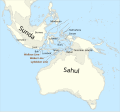
The disputed territory of West New Guinea
The West New Guinea dispute (1950–1962), also known as the West Irian dispute, was a diplomatic and political conflict between the Netherlands and Indonesia over the territory of Dutch New Guinea. While the Netherlands had ceded sovereignty over most of the Dutch East Indies to Indonesia on 27 December 1949 following an independence struggle, it retained control over its colony on the western half of New Guinea. The Indonesian government claimed this territory as well, on the basis that it had belonged to the Dutch East Indies and that the new Republic of Indonesia was the legitimate successor to the former Dutch colony.
During the first phase of the dispute (1950–1954), Indonesia pursued bilateral negotiations with the Netherlands. During the second phase (1954–1958), Indonesia attempted to raise support for its territorial claims in the United Nations General Assembly. During the third phase (1960–1962), Indonesia pursued a policy of confrontation against the Netherlands which combined diplomatic, political, and economic pressure with limited military force. The final stage of the confrontation with Indonesia also involved a planned military invasion of the territory. The Indonesians also secured military weapons and political and military support from the Soviet Union, which induced the United States to intervene in the conflict as a third-party mediator between Indonesia and the Netherlands. Following the New York Agreement on 15 August 1962, the Netherlands, under U.S. pressure, handed West New Guinea over to a United Nations Temporary Executive Authority, which subsequently handed the territory over to Indonesia on 1 May 1963. Following a controversial plebiscite in 1969, West New Guinea was formally integrated into Indonesia. (Full article...) -
The Landing at Nadzab was an airborne landing on 5 September 1943 during the New Guinea campaign of World War II in conjunction with the landing at Lae. The Nadzab action began with a parachute drop at Lae Nadzab Airport, combined with an overland force.
The parachute drop was carried out by the US Army's 503rd Parachute Infantry Regiment and elements of the Australian Army's 2/4th Field Regiment into Nadzab, New Guinea in the Markham Valley, observed by General Douglas MacArthur, circling overhead in a B-17. The Australian 2/2nd Pioneer Battalion, 2/6th Field Company, and B Company, Papuan Infantry Battalion reached Nadzab after an overland and river trek that same day and began preparing the airfield. The first transport aircraft landed the next morning, but bad weather delayed the Allied build up. Over the next days, the 25th Infantry Brigade of the Australian 7th Division gradually arrived. An air crash at Jackson's Field ultimately caused half the Allied casualties of the battle.
Once assembled at Nadzab, the 25th Infantry Brigade commenced its advance on Lae. On 11 September, it engaged the Japanese soldiers at Jensen's Plantation. After defeating them, it engaged and defeated a larger Japanese force at Heath's Plantation. During this skirmish, Private Richard Kelliher won the Victoria Cross, Australia's highest award for gallantry. Instead of fighting for Lae, the Japanese Army withdrew over the Saruwaged Range. This proved to be a gruelling test of endurance for the Japanese soldiers who had to struggle over the rugged mountains; in the end, the Japanese Army managed to withdraw its forces from Salamaua and Lae, though with extensive losses from exposure and starvation during the retreat. Troops of the 25th Infantry Brigade reached Lae shortly before those of the 9th Division that had been advancing on Lae from the opposite direction. (Full article...) -
Raja Ampat, or the Four Kings, is an archipelago located off of the northwest tip of Bird's Head Peninsula (on the island of New Guinea), Southwest Papua province, Indonesia. It comprises over 1,500 small islands, cays, and shoals around the four main islands of Misool, Salawati, Batanta, and Waigeo, and the smaller island of Kofiau.
The Raja Ampat archipelago straddles the equator and forms part of the Coral Triangle, an area of Southeast Asian seas containing the richest marine biodiversity on earth. The Coral Triangle itself is an approximate area west-southwest of the Philippines, east-northeast and southeast of the island of Borneo, and north, east and west of the island of New Guinea, including the seas in between. Thousands of species of marine organisms, from the tiniest cleaner shrimp and camouflaged pygmy seahorses to the majestic cetaceans and whale sharks, thrive in these waters.
Administratively, the archipelago is part of the province of Southwest Papua. Most of the islands constitute the Raja Ampat Regency, which was separated from Sorong Regency in 2004. The regency encompasses around 70,000 square kilometres (27,000 sq mi) of land and sea, of which 8,034.44 km2 constitutes the land area and has a population of 64,141 at the 2020 Census; the official estimate as at mid 2022 was 66,839. This excludes the southern half of Salawati Island, which is not part of this regency but instead constitutes the Salawati Selatan and Salawati Tengah Districts of Sorong Regency. (Full article...) -

Dendrobium discolor, commonly known as antler orchid or golden orchid, is a species of epiphytic or lithophytic orchid in the family Orchidaceae, and are native to northern Australia, New Guinea, and part of Indonesia. It has cylindrical pseudobulbs, each with between ten and thirty five leathery leaves, and flowering stems with up to forty mostly brownish or greenish flowers with wavy and twisted sepals and petals. (Full article...) -

APEC 2018 in Papua New Guinea
Papua New Guinea's foreign policy reflects close ties with Australia and other traditional allies and cooperative relations with neighboring countries. Its views on international political and economic issues are generally moderate.
Papua New Guinea belongs to a variety of regional organizations, including the Asia-Pacific Economic Cooperation (APEC) forum; the ASEAN Regional Forum (ARF) (Papua New Guinea is an observer member of the ASEAN); the South Pacific Commission; the Pacific Islands Forum; the Melanesian Spearhead Group and the South Pacific Regional Environmental Program (SPREP).
Papua New Guinea has been a member of The Forum of Small States (FOSS) since the group's founding in 1992. (Full article...)


.svg)
_and_west_ridge_by_Christian_Stangl_flickr.jpg)

.jpg)


Did you know (auto-generated)

- ... that David Dexter, who wrote the New Guinea volume in the series Australia in the War of 1939–1945, was a commando who served in East Timor and New Guinea?
- ... that Australian official Jack Emanuel was awarded the George Cross in 1971 after being stabbed to death whilst trying to resolve a land dispute with the Tolai people of New Guinea?
- ... that Australiformis semoni is a parasite that infests marsupials in Australia and New Guinea and whose infestation could cause debilitating ulcerative granulomatous gastritis?
- ... that artifacts of Papua New Guinean art were called "living spirits with fixed abodes"?
- ... that until Rufina Peter and Kessy Sawang's election in August 2022, Papua New Guinea was one of only three countries without a woman in parliament?
- ... that Dorkas Tokoro-Hanasbey, the only female member of the New Guinea Council, arrived thirty minutes late to her inauguration ceremony?
General images -
-

-
 The floristic region of Malesia (from New Guinea)
 -
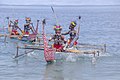
 Fishing boats in Biak (from Western New Guinea)
 -
 British flag raised in Queensland 1883 (from History of Papua New Guinea)
 -
 Jayapura, the most populus and largest cities on the island of New Guinea (Papua) (from New Guinea)
 -
 The lowland rainforest of the Western New Guinea (from Western New Guinea)
 -
 Grasberg Mine in Mimika Regency. Mining is the most important sector in the province (from Western New Guinea)
 -
 Western New Guinea was formally annexed by Indonesia in 1969. (from New Guinea)
 -
 Free West Papua protest in Melbourne, Australia, August 2012. (from Western New Guinea)
 -
 The Nagarakertagama mentioned a region in the east called Wanin, present-day Onin Peninsula in the Fakfak Regency, West Papua (from Western New Guinea)
 -
 Tifa, a Papuan musical instrument (from Western New Guinea)
 -
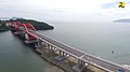 Youtefa Bridge, currently the longest bridge in Papua (from Western New Guinea)
 -
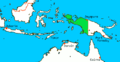
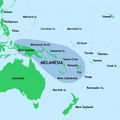 New Guinea located in relation to Melanesia (from New Guinea)
 -
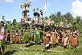
 Local people from Biak during a ceremony (from Western New Guinea)
 -
 Kepala Panjang dance, a sacred healing ritual to absorb negative energy of the Draa people from Yaffi District in Keerom. (from Western New Guinea)
 -
 Map showing the combined landmass of Sahul formed during Pleistocene glacations (from New Guinea)
 -
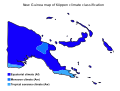 Papua New Guinea map of Köppen climate classification (from New Guinea)
 -
 Fort Du Bus in 1828 (from Western New Guinea)
 -
 Yali in the Yahukimo Regency (from Western New Guinea)
 -
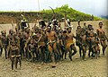
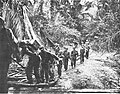
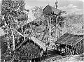
 Group of natives at Mairy Pass. Mainland of British New Guinea in 1885. (from New Guinea)
 -
 Dutch colonial civil servant in the Baliem Valley, 1958 (from Western New Guinea)
 -
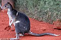 Dorcopsis hageni, native to northern region of New Guinea. (from Western New Guinea)
 -
 Traditional Papuan dagger (from Western New Guinea)
 -
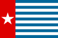
 West Papuan separatists raising the Morning-Star flag in the jungles of Papua, 1971 (from Western New Guinea)
 -
 A section of Trans-Papua Highway connecting Deiyai and Mimika in Central Papua (from Western New Guinea)
 -
 A 1644 map of New Guinea and the surrounding area (from New Guinea)
 -
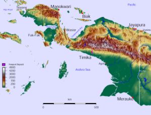
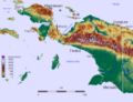
 Topographical map of New Guinea (from New Guinea)
 -
 Flag under German control of New Guinea. (from History of Papua New Guinea)
 -
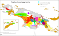
 Political divisions of New Guinea (2006) (from New Guinea)
 -
 New Guinea crocodile (from New Guinea)
 -
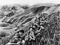 Australian soldiers resting in the Finisterre Ranges of New Guinea while en route to the front line (from New Guinea)
 -
 Papuans on the Lorentz River, photographed during the third South New Guinea expedition in 1912–13 (from New Guinea)
 -
-
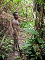 Korowai tribesman (from New Guinea)
 -
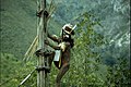
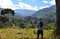 Highlands of Papua New Guinea (from New Guinea)
 -
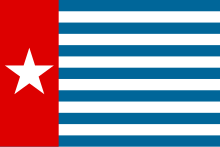
 Since 2002, display of the flag of West Papua is allowed in West Papua only if accompanied by, and not raised higher than, the flag of Indonesia. (from Western New Guinea)
 -
A typical map from the Golden Age of Netherlandish cartography. Australasia during the Golden Age of Dutch exploration and discovery (ca. 1590s–1720s): including Nova Guinea (New Guinea), Nova Hollandia (mainland Australia), Van Diemen's Land (Tasmania), and Nova Zeelandia (New Zealand). (from History of Papua New Guinea)
-
 Dutch expeditions in Netherlands New Guinea 1907–1915. (from Western New Guinea)
 -
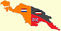 New Guinea from 1884 to 1919. The Netherlands controlled the western half of New Guinea, Germany the north-eastern part, and Britain the south-eastern part. (from New Guinea)
 -
 A Japanese military map of New Guinea from 1943 (from New Guinea)
 -
 Handover ceremony of West Irian Governorship from Jan Bonay to Frans Kaisiepo, 1965 (from Western New Guinea)
 -
 An Australian soldier, Private George "Dick" Whittington, is aided by Papuan orderly Raphael Oimbari, near Buna on 25 December 1942. (from History of Papua New Guinea)
 -
 The king bird-of-paradise is one of over 300 bird species on the peninsula. (from Western New Guinea)
 -
![Image 44M.S. Rumagesan, Silas Papare, N.L.Suwages, Soegoro Atmoprasodjo [id], and A.H. Nasution in Putra-putra Irian Barat ('Sons of Irian Barat') Conference in Cibogo Bogor, 14–15 April 1961 (from Western New Guinea)](//upload.wikimedia.org/wikipedia/commons/thumb/7/74/MS_Rumagesan%2C_Silas_Papare%2C_NL_Suwages%2C_Sugoro%2C_dan_AH_Nasution_berbincang-bincang%2C_Konferensi_Cibogo.jpg/120px-MS_Rumagesan%2C_Silas_Papare%2C_NL_Suwages%2C_Sugoro%2C_dan_AH_Nasution_berbincang-bincang%2C_Konferensi_Cibogo.jpg) M.S. Rumagesan, Silas Papare, N.L.Suwages, Soegoro Atmoprasodjo, and A.H. Nasution in Putra-putra Irian Barat ('Sons of Irian Barat') Conference in Cibogo Bogor, 14–15 April 1961 (from Western New Guinea)
M.S. Rumagesan, Silas Papare, N.L.Suwages, Soegoro Atmoprasodjo, and A.H. Nasution in Putra-putra Irian Barat ('Sons of Irian Barat') Conference in Cibogo Bogor, 14–15 April 1961 (from Western New Guinea) -
-
 Dutch and Papuan officials during the opening of the Central Hospital in Hollandia, 1959 (from Western New Guinea)
 -
 Hoisting the German flag at Mioko in 1884 (from History of Papua New Guinea)
 -
 Coral reefs in Papua New Guinea (from New Guinea)
 -

-
 Sentani International Airport in Jayapura is the principal point of entry to Papua (from Western New Guinea)
 -
 Regions of Oceania: Australasia, Polynesia, Micronesia, and Melanesia. Physiographically, Australasia includes the Australian landmass (including Tasmania), New Zealand, and New Guinea (from New Guinea)
 -
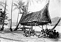
 Koiari village near Bootless Inlet, British New Guinea (from History of Papua New Guinea)
 -
The continent of Sahul before the rising ocean sundered Australia and New Guinea after the last ice age (from New Guinea)
-
 The rugged and mountainous topography of Western New Guinea. (from Western New Guinea)
 -
 The Sukarno-era West Irian Liberation Monument in Lapangan Banteng, Jakarta. (from Western New Guinea)
 -
 Papeda, a notable dish originating from Eastern Indonesia (from Western New Guinea)
 -
Dutch expeditions in Netherlands New Guinea 1907–1915. (from Western New Guinea)
-
 Map of New Guinea, with place names as used in English in the 1940s (from New Guinea)
 -
 Culture parade in Biak (from Western New Guinea)
 -

-
 The raggiana bird-of-paradise is native to New Guinea. (from New Guinea)
 -
-
Regions of Oceania: Australasia, Polynesia, Micronesia, and Melanesia. Australasia include the Australian landmass (including Tasmania), New Zealand, and New Guinea. (from History of Papua New Guinea)
-
 Rp 0.12 Indonesian stamp of 1963. (from Western New Guinea)
 -

-
 Skouw border checkpoint, on the Indonesia-Papua New Guinea border (from Western New Guinea)
 -
 Paradisaea apoda, native to Papua, displaying its feathers (from Western New Guinea)
 -
 Yali Mabel, Kurulu Village War Chief at Baliem Valley (from New Guinea)
 -
 Australian troops at Milne Bay, Papua.The Australian garrison was the first to inflict defeat on the Imperial Japanese Army during World War II at the Battle of Milne Bay of Aug–Sep 1942. (from History of Papua New Guinea)
 -
 Mount Bosavi (from New Guinea)
 -
 Trans-New Guinea languages (multi-coloured), Austronesian languages (gold), and other languages (grey) (from Western New Guinea)
 -
 Sago is a typical Papuan food, which is usually made into papeda. (from Western New Guinea)
 -
 New Guinea Volunteer Rifles with captured Japanese flag, 1942 (from History of Papua New Guinea)
 -
 Traditional Papuan war dance from the Yapen Islands (from Western New Guinea)


,_Pairi_daiza_2.jpg)


.jpg)

.png)


![Image 44M.S. Rumagesan, Silas Papare, N.L.Suwages, Soegoro Atmoprasodjo [id], and A.H. Nasution in Putra-putra Irian Barat ('Sons of Irian Barat') Conference in Cibogo Bogor, 14–15 April 1961 (from Western New Guinea)](/wiki/File:MS_Rumagesan,_Silas_Papare,_NL_Suwages,_Sugoro,_dan_AH_Nasution_berbincang-bincang,_Konferensi_Cibogo.jpg)


.jpg)

Related portals
WikiProjects
General topics
Categories

Associated Wikimedia
The following Wikimedia Foundation sister projects provide more on this subject:
-
 Commons
Free media repository -
 Wikibooks
Free textbooks and manuals -
 Wikidata
Free knowledge base -
 Wikinews
Free-content news -
 Wikiquote
Collection of quotations -
 Wikisource
Free-content library -
 Wikiversity
Free learning tools -
 Wiktionary
Dictionary and thesaurus
External media

More portals


