
Portal:Western Australia
Introduction Western Australia (commonly abbreviated as WA) is a state of Australia occupying the western third of the land area of Australia, excluding external territories. It is bounded by the Indian Ocean to the north and west, the Southern Ocean to the south, the Northern Territory to the north-east, and South Australia to the south-east. With a total land area of 2,527,013 square kilometres (975,685 sq mi), Western Australia is Australia's largest state as well as the second-largest subdivision of any country on Earth, surpassed only by the Sakha Republic in eastern Russia. the state has 2.76 million inhabitants—11 percent of the national total. The vast majority (92 percent) live in the south-west corner; 79 percent of the population lives in the Perth area, leaving the remainder of the state sparsely populated. The first Europeans to visit Western Australia belonged to the Dutch Dirk Hartog expedition, who visited the Western Australian coast in 1616. The first permanent European colony in what is today Western Australia occurred following the landing by Major Edmund Lockyer on 26 December 1826 of an expedition on behalf of the New South Wales colonial government. Lockyer established a convict-supported military garrison at King George III Sound, at present-day Albany, and on 21 January 1827 he formally took possession for the British Crown of the western part of the continent that was not already claimed by the Crown. This was followed by the establishment of the Swan River Colony in 1829, including the site of the present-day capital, Perth. (Full article...)
|


(Northern
Territory) |
 Good articles -
-

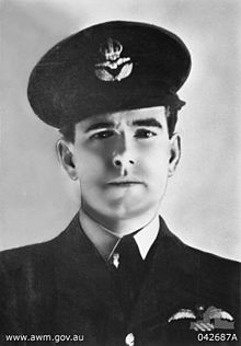
Air Commodore Sir Hughie Idwal Edwards, VC, KCMG, CB, DSO, OBE, DFC (1 August 1914 – 5 August 1982) was a senior officer in the Royal Air Force, Governor of Western Australia, and an Australian recipient of the Victoria Cross, the highest decoration for gallantry "in the face of the enemy" that can be awarded to members of the British and Commonwealth armed forces. Serving as a bomber pilot in the Royal Air Force (RAF), Edwards was decorated with the Victoria Cross in 1941 for his efforts in leading a bombing raid against the port of Bremen, one of the most heavily defended towns in Germany. He became the most highly decorated Australian serviceman of the Second World War.
Born in Fremantle, Western Australia, Edwards joined the Royal Australian Air Force in 1935, and a year later was granted a short service commission with the RAF. Serving throughout the Second World War, he gained a permanent commission and continued his career in the RAF after the war; he retired in 1963 with the rank of air commodore. Returning to Australia, he was appointed Governor of Western Australia in 1974. (Full article...) -
Severe Tropical Cyclone Bobby set numerous monthly rainfall records in parts of the Goldfields-Esperance regions of Western Australia, dropping up to 400 mm (16 in) of rain in February 1995. The fourth named storm of the 1994–95 Australian region cyclone season, Bobby developed as a tropical low embedded within a monsoon trough situated north of the Northern Territory coastline on 19 February. The storm gradually drifted southwestward and later southward under low wind shear, strengthening enough to be assigned the name Bobby by the Australian Bureau of Meteorology (BoM). The storm rapidly deepened as it approached the coast of Western Australia, and attained its peak intensity of 925 mbar (hPa; 27.32 inHg) at 0900 UTC on 24 February with 10-minute maximum sustained winds of 195 km/h (120 mph). After making landfall as a somewhat weaker cyclone near Onslow, the remnants of Bobby drifted southeastward, gradually weakening, before dissipating over the southern reaches of Western Australia.
Bobby inflicted minor damage throughout Western Australia, dropping copious rainfall and forcing the closure of many facilities and roads. The storm's destruction was most severe in Onslow, where 20 residences suffered damage. Elsewhere, Bobby knocked out power and water supplies, unroofed houses, tore off rain gutters, toppled fences, and smashed windows. The flooding of a 17 km (11 mi) stretch of the Eyre Highway stranded approximately 1000 vehicles, although the backup was later cleared more than a week later. Flooding disrupted mining and drilling operations throughout southwestern Australia, costing the industry upwards of $50 million (1995 AUD; $38.7 million USD). Numerous Australian Army and State Emergency Service (SES) personnel were involved in cleanup and recovery efforts after the cyclone's passage, while power and water service was restored to those cut off during the storm. Overall, the cyclone caused eight deaths and $11 million (1995 AUD; $8.5 million USD) in damage along its course across Western Australia. (Full article...) -
Severe Tropical Cyclone Alby was regarded as the most devastating tropical cyclone to impact southwestern Western Australia on record. Forming out of an area of low pressure on 27 March 1978, Alby steadily developed as it tracked southwestward, parallel to Western Australia. Between 1 and 2 April, the storm quickly intensified and attained its peak intensity as a Category 5 cyclone on the Australian cyclone intensity scale. After turning to the southeast, the storm underwent an extratropical transition as it neared Cape Leeuwin. The storm brushed the cape on 4 April, bringing hurricane-force winds, before rapidly losing its identity the following day.
In Western Australia, the combination of Alby's fast movement and hurricane-force winds caused widespread damage. Along the coast, large swells flooded low-lying areas and numerous homes lost their roofs from high winds. Further inland, bushfires were worsened by the storm as it brought little rain, generally less than 20 mm (0.79 in) along the coast. These fires burned roughly 114,000 hectares (281,700 acres). Cyclone Alby and the associated brushfires caused five deaths, with the heaviest damage in the town of Albany, Western Australia. A report at the time noted that "The Perth metropolitan area and nearly every town from Geraldton to Albany was extensively damaged." The resulting damage was extensive, with monetary losses reaching A$50 milelion (US$45 million). According to a Canadian newspaper, the Associated Press reported initially that officials in Perth said that "A tropical cyclone Tuesday tore across the southwestern tip of Australia, killing at least five persons and sparking brushfires that destroyed two towns,", but the two towns supposedly destroyed by fire were not identified, nor was there a report in the local press or subsequent investigations. (Full article...) -
Susie Bootja Bootja Napaltjarri (also referred to as Susie Bootja Bootja Napangardi, Napangarti, or Napangati) (c. 1935 – 16 January 2003) was an Indigenous artist from Australia's Western Desert region. Born south-west of Balgo, Western Australia, in the 1950s Susie Bootja Bootja married artist Mick Gill Tjakamarra, with whom she had a son, Matthew Gill Tjupurrula (also an artist).
Susie Bootja Bootja's painting career followed the establishment of Warlayirti Artists, an Indigenous art centre at Balgo. One of the area's strongest artists, her work was characterised by an expressive style, and has been acquired by major Australian galleries, including the Art Gallery of New South Wales and National Gallery of Victoria. She died in 2003. (Full article...) -
The Causeway is an arterial traffic crossing in Perth, Western Australia, linking the inner-city suburbs of East Perth and Victoria Park. It is carried over the Swan River at the eastern end of Perth Water by two bridges on either side of Heirisson Island. The current Causeway is the third structure to have been built across the river at this point.
Originally the site of mudflats which restricted river navigation, the Colony Government constructed a causeway and bridge across the site. The project was first planned in 1834 and opened in 1843. When floods in 1862 almost destroyed it, the structure was rebuilt using convict labour, and raised to better withstand future floods. Governor John Hampton officially opened the new Causeway on 12 November 1867. Over the following decades, the three bridges making up this second Causeway were widened several times, and they were eventually replaced in 1952. (Full article...) -
Nicolas Pierre Goiran (born 15 October 1977) is an Australian politician who has been a member for the South Metropolitan Region of the Western Australian Legislative Council (MLC), the upper house of the Parliament of Western Australia, since 22 May 2009.
A member of the Liberal Party, Australia's major centre-right political party, Goiran is a conservative Christian. He is pro-life, and opposes same-sex marriage, euthanasia and surrogacy. He has been outspoken on the issue of elder abuse, and he supports COVID-19 vaccinations but opposes COVID-19 vaccine mandates. Goiran has twice been accused of filibustering: he spoke for over 22 hours in total over a surrogacy bill in 2019, delaying it; and he proposed 357 amendments to a voluntary assisted dying bill and spoke on every clause of the bill. (Full article...) -
Severe Tropical Cyclone Glenda was among the strongest tropical cyclones to threaten Western Australia, though it weakened considerably before landfall and moved ashore in a lightly populated region. It began as a tropical low on 15 March in the Gulf of Carpentaria. The precursor disturbance drifted over Top End and later across the northeastern portion of Western Australia, and after emerging into the Indian Ocean it strengthened into a tropical storm. Aided by favourable environmental conditions, Glenda rapidly intensified to reach Category 5 status on the Australian cyclone scale, and with a peak intensity of 910 mbar it was among the strongest cyclones on record within the Australia region. On 30 March it moved ashore near Onslow as a Category 3 cyclone, and the next day it degenerated into a remnant tropical low over land.
The precursor disturbance produced heavy rainfall in the Kimberley region of Western Australia, causing record flooding and some road damage. Minor damage was reported at the final landfall of Glenda. Due to the sparse population and preparations made, the cyclone was not responsible for any deaths or injuries. However, its name was later retired from the list of tropical cyclone names. (Full article...) -
Charles Christian Porter (born 11 July 1970) is an Australian former politician and lawyer who served as the 37th Attorney-General of Australia from 2017 to 2021 in the Turnbull government and the subsequent Morrison government. He was a Member of Parliament (MP) for the Division of Pearce from 2013 to 2022 and a member of the Liberal Party of Australia. Porter also served as Leader of the House and Minister for Industrial Relations from 2019 to 2021, and Minister for Industry, Science and Technology in 2021 following his resignation as attorney-general.
From Perth, Porter attended Hale School, the University of Western Australia and later the London School of Economics, and practised law at Clayton Utz and taught law at the University of Western Australia before his election to parliament. He is the son of the 1956 Olympic silver medallist, Charles "Chilla" Porter and the grandson of Queensland Liberal politician, Charles Porter, who was a member of the Queensland Legislative Assembly from 1966 to 1980. (Full article...) -
Tropical Cyclone Herbie was the only known tropical system to impact Western Australia during the month of May on record. The final cyclone of the 1987–88 Australian region cyclone season, Herbie was first identified northwest of the Cocos Islands on 17 May. The following day, the system was classified as a tropical low by the Australian Bureau of Meteorology and intensified into a Category 1 cyclone later that day. Several hours after this upgrade, the storm attained its initial peak intensity with winds of 75 km/h (45 mph 10-minute sustained). Around the same time, the Joint Typhoon Warning Center classified Herbie as Tropical Storm 21S.
On 19 May, the cyclone formed a new low-pressure center and relocated roughly 300 km (190 mi) south. Shortly thereafter, the storm began to accelerate towards the southeast and started to undergo an extratropical transition. Early on 21 May, Herbie made landfall in Shark Bay before losing its identity the following day over the Great Australian Bight. Although a weak storm, Herbie brought flooding rains and severe dust storms to portions of Western Australia. Additionally, a 30,000 ton freighter broke in half amidst rough seas produced by the storm. Total losses from the storm reached A$20 million (US$15.6 million). Due to the significant damage wrought by Herbie, the name was retired following its use. (Full article...) -
Daglish is a small western suburb of Perth, the capital of Western Australia. It is approximately 4 kilometres (2.5 mi) west of the Perth central business district, and within the City of Subiaco local government area. It was named after Henry Daglish, who was the mayor of Subiaco, member for the electoral district of Subiaco and premier of Western Australia from 1904 to 1905. The Daglish railway station opened in 1924 in response to population growth in the neighbouring suburb of Subiaco. The following year, the Municipality of Subiaco bought the land west of the railway station to sell for housing. Development occurred over the following 20 years. The initial development next to the railway station used the garden suburb principles, with large lots and gardens, curved streets, and lots of green space. Today, the suburb has significant heritage value due to its uniform streetscape, with most original homes still standing. It has a population of 1,419 as of the 2016 Australian census. (Full article...) -
Kardinya is a suburb 13 kilometres (8 mi) south-southwest of the central business district of Perth, the capital of Western Australia. It is in the City of Melville local government area. It is predominantly a low-density residential suburb consisting of single-family detached homes. There is a commercial area in the centre of the suburb, with a shopping centre and several other shops. In the northwest is a small light industrial area. Kardinya has a population of 8,730 people.
Before European settlement, the area was inhabited by the Beeliar group of the Whadjuk Noongar people. Kardinya did not attract any interest from Europeans when the Swan River Colony was founded in 1829, as it was far away from any river and was not fertile. European use of Kardinya began in 1870 when fourteen lots were allocated to Pensioner Guards. These lots were used for piggeries, poultry farms and vineyards. In 1904, a large amount of land in the area was set aside as endowment land for the University of Western Australia. In the 1920s, this land started to be used as a pine plantation, known as the Applecross Pine Plantation, and, after 1947, the Somerville Pine Plantation. The suburb was formally gazetted on 16 June 1961. From 1967 to the early 1980s, suburban development occurred in Kardinya. (Full article...) -
Great Northern Highway is an Australian highway that links Western Australia's capital city Perth with its northernmost port, Wyndham. With a length of almost 3,200 kilometres (2,000 mi), it is the longest highway in Australia, with the majority included as part of the Perth Darwin National Highway. The highway, which travels through remote areas of the state, is constructed as a sealed, predominantly two-lane single carriageway, but with some single-lane bridges in the Kimberley. Economically, it provides vital access through the Wheatbelt and Mid West to the resource-rich regions of the Pilbara and Kimberley. In these areas, the key industries of mining, agriculture and pastoral stations, and tourism are all dependent on the highway.
In Perth, the highway begins in Midland near Great Eastern Highway, and further north intersects the Reid and Roe highways, which together form Perth's ring road. There are also three rural highways that spur off Great Northern Highway. Brand Highway and North West Coastal Highway provide an alternative coastal route between Muchea and Port Hedland, while Victoria Highway carries the National Highway route and interstate traffic into the Northern Territory. Various road routes are allocated to sections of Great Northern Highway, including the Highway 1 routes National Route 1 and National Highway 1, as well as National Highway 95. (Full article...) -
Greenwood railway station is a park and ride suburban railway station in Perth, Western Australia, within the suburbs of Duncraig and Greenwood. The station is on the Joondalup line and is part of the Transperth network. Located within the median strip of the Mitchell Freeway at an interchange with Hepburn Avenue, Greenwood station consists of two side platforms connected to a car park east of the freeway by a footbridge.
The station was included within early plans for the Joondalup line in the 1980s, but the final plan for the Joondalup line, which opened in December 1992, did not include the construction of Greenwood station. After several promises by the state government during the 1990s to build the station, a A$6.8 million contract was awarded to John Holland Group in February 2004 to construct the station. Construction began in March 2004, and the station opened on 29 January 2005, relieving pressure on the car parks at Warwick and Whitfords stations. (Full article...) -
Bayswater railway station is a suburban rail station in Bayswater, a suburb of Perth, Western Australia. It is the junction station for Transperth's Midland and Airport lines, and the Morley–Ellenbrook line when it opens in late 2024.
The station first opened in 1896 on the Perth to Midland railway with two side platforms and an adjacent goods yard. It served as the junction station for the Belmont spur line between 1896 and 1956. Bayswater station was rebuilt as an island platform just to the north in the late 1960s when the Midland line was converted from narrow gauge to dual gauge; the standard gauge trains were unable to fit between the side platforms. Around that time, the goods yard closed. (Full article...) -
Central Park is a 51-storey office tower in Perth, Western Australia. The building measures 226 m (741 ft) from its base at St Georges Terrace to the roof, and 249 m (817 ft) to the tip of its communications mast. Upon its completion in 1992, the tower became the tallest building in Perth, and was the 4th tallest in Australia from then till 2005. It is also currently the sixteenth tallest building in Australia (tied with the Infinity Tower) and the tallest building in the western half of Australia.
The approval of the tower was controversial due to the plot ratio concessions made by the Perth City Council to the developers. These concessions enabled the developers to construct a tower more than twice the height which would otherwise be allowable on the site. There was also opposition to the Council's decision to ignore its own town planning experts in allowing a large car park to be constructed underneath the site. (Full article...)


.png)


Did you know (auto-generated)

- ... that Western Australia was the second Australian state to legalise voluntary assisted dying?
- ... that the search for a lost radioactive capsule along a 1,400-kilometre (870 mi) stretch of road in Western Australia was likened to looking for a needle in a haystack?
- ... that Bill Dunn, an Indigenous Australian pastoralist approaching retirement, sold his station at half-price to the Jigalong community despite receiving full-price offers from non-Indigenous people?
- ... that Mertome Village in Bayswater, Western Australia was the first aged care complex to be built by a local government in Australia?
- ... that politician John D'Orazio helped to secure a three-year trial of daylight saving time in Western Australia?
- ... that Nick Goiran, a member of the Western Australian Legislative Council, proposed 357 amendments to a voluntary assisted dying bill?
Categories

More portals
More did you know...

- ...that when the 1987 America's Cup was raced off Fremantle, Western Australia it was the first time for 132 years that the regatta had not been hosted by the New York Yacht Club?
- ...that the original Victoria Dam, constructed in 1891, was the first dam in Western Australia, and it stood for almost 100 years before being replaced with the current dam?
- ...that Anglican bishop Kay Goldsworthy was consecrated as the first woman bishop of any Australian church on 22 May 2008?
Related WikiProjects

Things you can do
Here are some tasks you can do to help with WikiProject Western Australia:
Associated Wikimedia
The following Wikimedia Foundation sister projects provide more on this subject:
-
 Commons
Free media repository -
 Wikibooks
Free textbooks and manuals -
 Wikidata
Free knowledge base -
 Wikinews
Free-content news -
 Wikiquote
Collection of quotations -
 Wikisource
Free-content library -
 Wikispecies
Directory of species -
 Wikiversity
Free learning tools -
 Wikivoyage
Free travel guide -
 Wiktionary
Dictionary and thesaurus


