Xiaobailou Subdistrict
Xiaobailou Subdistrict
小白楼街道 | |
|---|---|
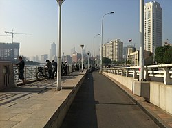
 Binjiang Road near Hai River, 2012 | |
 Location of Xiaobailou Subdistrict within Heping District | |
| Coordinates: 39°07′05″N 117°12′22″E / 39.11806°N 117.20611°E | |
| Country | China |
| Municipality | Tianjin |
| District | Heping |
| Village-level Divisions | 9 communities |
| Area | |
• Total | 2.3 km2 (0.9 sq mi) |
| Elevation | 8 m (26 ft) |
| Population (2010) | |
• Total | 30,982 |
| • Density | 13,000/km2 (35,000/sq mi) |
| Time zone | UTC+8 (China Standard) |
| Postal code | 300041 |
| Area code | 022 |
Xiaobailou Subdistrict (simplified Chinese: 小白楼街道; traditional Chinese: 小白樓街道; pinyin: Xiǎobáilóu Jiēdào) is a subdistrict of Heping District, Tianjin.[1] it borders Guangfudao Subdistrict in the north, Dawangzhuang Subdistrict in the east, Dayingmen and Wudadao Subdistrict in the south, and Quanyechang Subdistrict in the west. It was once part of the American concession of Tianjin. As of 2010, its population was 30,982.[2]
The name Xiaobailou (Chinese: 小白楼; lit. 'Small White Building') originated back when this region was a foreign concession. Since the area did not have an official name yet, it was named after a two-story pub that was a local landmark.[3]
Geography
[edit]Xiaobailou Subdistrict is located on the west bank of Hai River.
History
[edit]| Year | Status | Part of |
|---|---|---|
| 1952 - 1955 | Jiefangqiao Street | 1st District, Tianjin |
| Xiaobailou Street
Dagu Road Street |
5st District, Tianjin | |
| 1955 - 1956 | Jiefangqiao Subdistrict | 1st District, Tianjin |
| Xiaobailou Subdistrict
Dagu Road Subdistrict |
5st District, Tianjin | |
| 1956 - 1958 | Jiefangqiao Subdistrict | Heping District, Tianjin |
| Xiabailou Subdistrict | Xinhua District, Tianjin | |
| 1958 - 1960 | Jiefangqiao Subdistrict
Xiabailou Subdistrict |
Heping District, Tianjin |
| 1960 - 1962 | Quanyechang People's Commune
Xiaobailou People's Commune | |
| 1962 - 1964 | Jiefangqiao Subdistrict
Xiaobailou Subdistrict Xinhua Road Subdistrict | |
| 1964 - 1998 | Jiefangqiao Subdistrict
Xiaobailou Subdistrict | |
| 1998 - present | Xiaobailou Subdistrict |
Administrative divisions
[edit]As of 2021, Xiaobailou Subdistrict was made up of the following 9 communities:[4]
| Subdivision Names | Name Transliterations |
|---|---|
| 泰安道 | Tai'andao |
| 树德里 | Shudeli |
| 崇仁里 | Chongrenli |
| 承德道 | Chengdedao |
| 长春道 | Changchundao |
| 解放路 | Jiefanglu |
| 达文里 | Dawenli |
| 大同道 | Datongdao |
| 开封道 | Kaifengdao |
Gallery
[edit]-
Former residence of Yuan Shikai, 2009
-
Zhejiang Road within the subdistrict, 2014
-
Nanjing Road on the south of the subdistrict, 2014
-
Astor Hotel in Tianjin, 2020
References
[edit]- ^ "天津市和平区人民政府-关于发布2021版天津市和平区行政区划图的公告_其他法定公开信息". www.tjhp.gov.cn. Retrieved 2022-11-01.
- ^ "中國: 天津市 (区、乡、镇、街道) - 人口统计,图表和地图". www.citypopulation.de. Retrieved 2022-11-01.
- ^ a b 中华人民共和国政区大典:天津市卷 (in Chinese). 中国社会出版社. 2020.
- ^ "2021年统计用区划代码和城乡划分代码". www.stats.gov.cn. Retrieved 2022-11-02.


