Nanyingmen Subdistrict
Appearance
Nanyingmen Subdistrict
南营门街道 | |
|---|---|
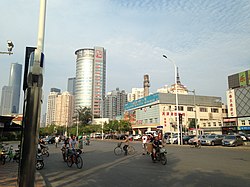
 Yingkou Avenue on the southeastern side of the subdistrict, 2016 | |
 Location of Nanyingmen Subdistrict in Heping District | |
| Coordinates: 39°07′05″N 117°10′42″E / 39.11806°N 117.17833°E | |
| Country | China |
| Municipality | Tianjin |
| District | Heping |
| Village-level Divisions | 10 communities |
| Area | |
• Total | 1.26 km2 (0.49 sq mi) |
| Elevation | 9 m (30 ft) |
| Population (2010) | |
• Total | 47,306 |
| • Density | 38,000/km2 (97,000/sq mi) |
| Time zone | UTC+8 (China Standard) |
| Postal code | 300041 |
| Area code | 022 |
Nanyingmen Subdistrict (simplified Chinese: 南营门街道; traditional Chinese: 南營門街道; pinyin: Nányíngmén Jiēdào) is a subdistrict situated on the west of Heping District, Tianjin.[1] it shares border with Quanyechang Subdistrict in its north, Wudadao Subdistrict in its east, Xinxing Subdistrict in its south, as well as Xuefu and Wanxing Subdistricts in its west. In 2010, It had a population of 47,306.[2]
The name Nanyingmen literally translates to "South Camp Gate".
History
[edit]| Year | Status | Within |
|---|---|---|
| 1955 - 1956 | Nanyingmen Subdistrict
Dihuadao Subdistrict Tongtaili Subdistrict |
5th District, Tianjin |
| 1956 - 1958 | Nanyingmen Subdistrict
Guiyang Road Subdistrict |
Xinua District, Tianjin |
| 1958 - 1960 | Nanyingmen Subdistrict | Heping District, Tianjin |
| 1960 - 1962 | Nanyingmen People's Commune | |
| 1962 - 1964 | Nanyingmen Subdistrict
Guiyang Road Subdistrict | |
| 1964 - present | Nanyingmen Subdistrict (Part of Xinxing Subdistrict joined in 1998) |
Administrative divisions
[edit]At the time of writing, Nanyingmen Subdistrict is composed of 10 communities, which are listed as follows:[4]
| Subdivision Names | Name Transliterations |
|---|---|
| 昆明路 | Kunminglu |
| 西宁道 | Xiningdao |
| 天兴里 | Tianxingli |
| 竞业里 | Jingyeli |
| 绵阳道 | Jinyangdao |
| 世昌里 | Shichangli |
| 香榭里 | XInagxieli |
| 天新里 | Tianxinli |
| 文化村 | Wenhuacun |
| 海光寺 | Haiguangsi |
Landmark
[edit]Gallery
[edit]-
Xikai Church, 2007
-
Haiguangsi Residential Community northwest of the subdistrict, 2009
-
Aerial view of the subdistrict, 2011
-
Xining Avenue, 2011
References
[edit]- ^ "天津市和平区人民政府-关于发布2021版天津市和平区行政区划图的公告_其他法定公开信息". www.tjhp.gov.cn. Retrieved 2022-11-01.
- ^ "中國: 天津市 (区、乡、镇、街道) - 人口统计,图表和地图". www.citypopulation.de. Retrieved 2022-11-01.
- ^ 中华人民共和国政区大典:天津市卷 (in Chinese). 中国社会出版社. 2020.
- ^ "2021年统计用区划代码和城乡划分代码". www.stats.gov.cn. Retrieved 2022-11-02.


