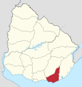
Villa Delia
Appearance
Villa Delia | |
|---|---|
Suburb of Maldonado | |
| Coordinates: 34°52′58″S 54°59′8″W / 34.88278°S 54.98556°W | |
| Country | |
| Department | Maldonado Department |
| Population (2011) | |
• Total | 1,703 |
| Time zone | UTC -3 |
| Postal code | 20000 |
| Dial plan | +598 42 (+6 digits) |
Villa Delia is a suburb of Maldonado, Uruguay.
Geography
[edit]The suburb is located on Route 38 and borders the suburbs Cerro Pelado and La Sonrisa to the west, Barrio Los Aromos to the north, and Pinares - Las Delicias to the south.
Population
[edit]In 2011 Villa Delia had a population of 1,703.[1]
| Year | Population |
|---|---|
| 1985 | 365 |
| 1996 | 583 |
| 2004 | 623 |
| 2011 | 1,703 |
Source: Instituto Nacional de Estadística de Uruguay[2]
References
[edit]- ^ "Censos 2011 Cuadros Maldonado". INE. 2012. Archived from the original on October 10, 2012. Retrieved 25 August 2012.
- ^ "1963–1996 Statistics / V" (DOC). Instituto Nacional de Estadística de Uruguay. 2004. Retrieved 7 July 2011.
External links
[edit]


