Struhařov (Benešov District)
Struhařov | |
|---|---|
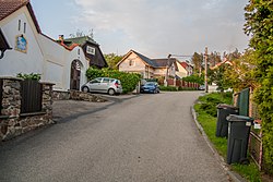
 A street in Struhařov | |
| Coordinates: 49°45′56″N 14°45′44″E / 49.76556°N 14.76222°E | |
| Country | |
| Region | Central Bohemian |
| District | Benešov |
| First mentioned | 1370 |
| Area | |
• Total | 21.96 km2 (8.48 sq mi) |
| Elevation | 448 m (1,470 ft) |
| Population (2024-01-01)[1] | |
• Total | 995 |
| • Density | 45/km2 (120/sq mi) |
| Time zone | UTC+1 (CET) |
| • Summer (DST) | UTC+2 (CEST) |
| Postal code | 256 01 |
| Website | obecstruharov |
Struhařov is a municipality and village in Benešov District in the Central Bohemian Region of the Czech Republic. It has about 1,000 inhabitants.
Administrative parts
[edit]The villages and hamlets of Babčice, Bořeňovice, Budkov, Býkovice, Dolní Podhájí, Hliňánky, Horní Podhájí, Jezero, Myslíč, Pecínov, Skalice, Střížkov, Svatý Jan and Věřice are administrative parts of Struhařov.
Etymology
[edit]The name is derived either from the personal name Strhař or Struhař (meaning "Strhař's/Struhař's (court)"), or from strhař, which is an old Czech word for a craftsman who makes boards.[2]
Geography
[edit]Struhařov is located about 5 kilometres (3 mi) east of Benešov and 36 km (22 mi) southeast of Prague. It lies in the Benešov Uplands. The highest point is the hill Hůrka at 519 m (1,703 ft) above sea level. The municipal territory is rich in small fishponds.
History
[edit]The first written mention of Struhařov is from 1370. In 1650, Struhařov was owned by the Lords of Říčany and was a separate estate. They sold the estate to Count František Adam Trautmannsdorf in 1717. After his death in 1762, Struhařov often changed owners.[3][4]
Demographics
[edit]
|
|
| ||||||||||||||||||||||||||||||||||||||||||||||||||||||
| Source: Censuses[5][6] | ||||||||||||||||||||||||||||||||||||||||||||||||||||||||
Transport
[edit]Struhařov is located on the railway line Benešov–Vlašim.[7]
Sights
[edit]
The main landmark of Struhařov is the Chapel of the Virgin Mary. It was built in the second half of the 18th century.[8]
A cultural monument is the castle in Střížkov. It was probably built at the beginning of the 19th century. Today the building is unused.[9]
References
[edit]- ^ "Population of Municipalities – 1 January 2024". Czech Statistical Office. 2024-05-17.
- ^ Profous, Antonín (1957). Místní jména v Čechách IV: S–Ž (in Czech). p. 216.
- ^ "Struhařov" (in Czech). Obec Struhařov. Retrieved 2024-09-13.
- ^ "Historie Struhařova" (in Czech). Obec Struhařov. Retrieved 2024-09-13.
- ^ "Historický lexikon obcí České republiky 1869–2011" (in Czech). Czech Statistical Office. 2015-12-21.
- ^ "Population Census 2021: Population by sex". Public Database. Czech Statistical Office. 2021-03-27.
- ^ "Detail stanice Struhařov" (in Czech). České dráhy. Retrieved 2024-09-13.
- ^ "Kaple Panny Marie" (in Czech). National Heritage Institute. Retrieved 2024-09-13.
- ^ "Zámek" (in Czech). National Heritage Institute. Retrieved 2024-09-13.


