Roscommon (barony)
Roscommon
Ros Comáin (Irish) | |
|---|---|
 Gates of Strokestown Park | |
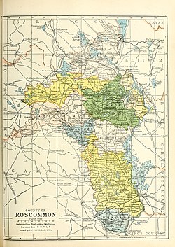
 Barony map of County Roscommon, 1900; Roscommon barony is coloured green, in the centre. | |
| Sovereign state | Ireland |
| Province | Connacht |
| County | Roscommon |
| Area | |
| • Total | 330.16 km2 (127.47 sq mi) |
Roscommon (Irish: Ros Comáin[1]) is a barony in County Roscommon, Ireland.[2][3]
Etymology
[edit]Roscommon barony is named after Roscommon town; however, it does not actually contain that town, which is located in Ballintober South.[4]
Geography
[edit]Roscommon barony is located in the centre of County Roscommon, an area with many lakes including Lough Boderg.[5][6] The only mountain is Slieve Bawn.[7]
History
[edit]The Mag Oireachtaigh (Mageraghtys) were rulers here of Clann Tomaltaigh and the Muintir Roduib.
The Ó Fídhne (O'Feeney) were also in Roscommon barony. The O'Mulconaire were hereditary historians and bards.
The Ó Maoilbhreanainn (O'Mulrenan) sept were chiefs of Clann Chonchobhair (O'Conor).[8][unreliable source?]
It is referred to in the topographical poem Tuilleadh feasa ar Éirinn óigh (Giolla na Naomh Ó hUidhrín, d. 1420):
OMaoilbrenaiin co mbladaiḃ
Ar Cloinn clármaoith Conċoḃair
A maicne os gaċ droing do dliġ
An aicme do Cloinn Chathail.
[...]
Ag Mág Oireaċtaiġ na n-each
Muintir Roduiḃ na righḃreaṫ
("O'Maoilbhrenainn with fame over the irriguous plain of Clann-Conchobhair, Their children are entitled to be above every tribe, that sept of the Clann-Cathail. [...] To Mac Oireachtaigh of the steeds belong Muintir Roduibh of royal judgments.")[9][10]
List of settlements
[edit]Below is a list of settlements in Roscommon barony:
See also
[edit]References
[edit]- ^ "Ros Comáin/Roscommon". Logainm.ie.
- ^ "A map of Cloonfad Beg in the barony and County of Roscommon. Names of tenants and acreage of holdings shown". catalogue.nli.ie. 1770.
- ^ "Historical Notes. 1509-1714". G.E. Eyre and W. Spottiswoode. 1 January 2019 – via Google Books.
- ^ Carlisle, Nicholas (1 January 2019). "A Topographical Dictionary of Ireland: Exhibiting the Names of the Several Cities, Towns, Parishes, and Villages ... Collected from the Most Authentic Documents, and Arranged in Alphabetical Order. Being a Continuation of the Topography of the United Kingdom of Great Britain and Ireland". W. Miller – via Google Books.
- ^ "CREEVE, a parish". www.libraryireland.com.
- ^ "Roscommon Civil Parish of Killukin (Roscommon) map". www.leitrim-roscommon.com.
- ^ Weld, Isaac; Society, Royal Dublin (1832). Statistical survey of the county of Roscommon. Printed by R. Graisberry. p. 582 – via Internet Archive.
barony of Roscommon.
- ^ "The Baronies of Ireland - Family History". sites.rootsweb.com.
- ^ http://www.aughty.org/pdf/ui_mani_ui_fiacrach.pdf [bare URL PDF]
- ^ "The Topographical Poems of John O'Dubhagain and Giolla-na-naomh O'Huidhrin: Edited in the original Irish from MSS. in the Library of the Royal Irish Academy, Dublin, with translation, notes, and introductory dissertations, by John O'Donovan". A. Thom. 8 July 1862 – via Google Books.


