Ballintober South
Appearance
Ballintober South
Baile an Tobair Theas (Irish) | |
|---|---|
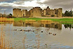
 The Castle, Roscommon town, Ballintober South | |
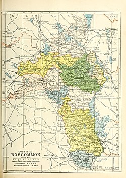
 Barony map of County Roscommon, 1900; Ballintober South is coloured peach, in the centre. | |
| Sovereign state | Ireland |
| Province | Connacht |
| County | Roscommon |
| Area | |
• Total | 194.71 km2 (75.18 sq mi) |
Ballintober South (Irish: Baile an Tobair Theas[1]), also called Ballintober West, is a barony in County Roscommon, Ireland.[2]
Etymology
[edit]Ballintober South is named after Ballintober town; however, it does not actually contain that town, which is located in Castlereagh barony.
Geography
[edit]Ballintober South is located in the centre of County Roscommon, northwest of Lough Ree.
History
[edit]The Ó Manacháin (O'Monaghans) were lords of the "Three Tuathas", and in AD 866 were rulers of this area, known as Ui Briuin na Sionna (O'Brien of the Shannon).[3] In 1249, they were overthrown by the O'Beirnes (Ó Birn).[4][5]
The O'Mooneys were chiefs of Clann-Murthuile, also believed to be in Ballintober South.[6]
List of settlements
[edit]Below is a list of settlements in Ballintober South:
References
[edit]- ^ "Baile an Tobair Theas/Ballintober South". Logainm.ie.
- ^ Bd, Ireland National Education (3 January 2019). "Annual Report of the Commissioners ..." – via Google Books.
- ^ "Ui Briuin na Sionna - Irish Names and Surnames". www.libraryireland.com.
- ^ "Ó Birn - Irish Names and Surnames". www.libraryireland.com.
- ^ "The Baronies of Ireland - Family History". sites.rootsweb.com.
- ^ "Irish Chiefs and Clans in Roscommon and Galway - Irish Pedigrees". libraryireland.com. Archived from the original on 3 June 2021.


