Portal:Tropical cyclones
The Tropical Cyclones Portal
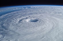
A tropical cyclone is a storm system characterized by a large low-pressure center, a closed low-level circulation and a spiral arrangement of numerous thunderstorms that produce strong winds and heavy rainfall. Tropical cyclones feed on the heat released when moist air rises, resulting in condensation of water vapor contained in the moist air. They are fueled by a different heat mechanism than other cyclonic windstorms such as Nor'easters, European windstorms and polar lows, leading to their classification as "warm core" storm systems. Most tropical cyclones originate in the doldrums, approximately ten degrees from the Equator.
The term "tropical" refers to both the geographic origin of these systems, which form almost exclusively in tropical regions of the globe, as well as to their formation in maritime tropical air masses. The term "cyclone" refers to such storms' cyclonic nature, with anticlockwise rotation in the Northern Hemisphere and clockwise rotation in the Southern Hemisphere. Depending on its location and intensity, a tropical cyclone may be referred to by names such as "hurricane", "typhoon", "tropical storm", "cyclonic storm", "tropical depression" or simply "cyclone".
Types of cyclone: 1. A "Typhoon" is a tropical cyclone located in the North-west Pacific Ocean which has the most cyclonic activity and storms occur year-round. 2. A "Hurricane" is also a tropical cyclone located at the North Atlantic Ocean or North-east Pacific Ocean which have an average storm activity and storms typically form between May 15 and November 30. 3. A "Cyclone" is a tropical cyclone that occurs in the South Pacific and Indian Oceans.
Selected named cyclone -
Hurricane Manuel (/ˌmæn(j)uˈɛl, ˌmɑːn-/) was a catastrophic tropical cyclone that brought widespread flooding across much of Mexico in September 2013, in conjunction with Hurricane Ingrid. The fifteenth named storm and seventh hurricane of the annual hurricane season, Manuel originated from a strong area of low pressure south of Acapulco on September 13. Within favorable conditions aloft, the storm intensified into a tropical storm as it tracked northward. The following day, Manuel curved westward and strengthened to a point just shy of hurricane intensity before making its first landfall at that intensity on September 15. Due to interaction with land, the tropical storm quickly weakened, and its center dissipated over western Mexico on September 16. However, the storm's remnants continued to track northwestward into the Gulf of California, where they reorganized into a tropical cyclone the next day. Manuel regained tropical storm status on September 18 as it began to curve northeastward. Shortly thereafter, Manuel attained Category 1 hurricane intensity, before making its final landfall just west of Culiacán at peak intensity. Over land, Manuel quickly weakened due to interaction with Mexico's high terrain, and the storm dissipated early on September 20.
Due to the impending threat of Manuel, several Mexican municipalities were put under disaster alerts. Upon making its first landfall, Manuel caused extreme flooding in southern Mexico. Property and agricultural damage as a result of the system was widespread, and roughly one million people were estimated to have been directly affected. In Guerrero, 97 people perished, including 18 in Acapulco. Seventy-one others died due to a mudslide in La Pintada. In Guerrero alone, around 30,000 homes were damaged and 46 rivers overflowed their banks. There, 20,000 persons were evacuated to shelters. Statewide, repairs to damage from the storm totaled MXN$3 billion ($230 million USD). Other impacts from Manuel spread as far east as the Isthmus of Tehuantepec, where 300 families were displaced. In the region, at least 11,591 homes were destroyed by the floods. Meanwhile, the nation sustained additional impacts from Atlantic Hurricane Ingrid. (Full article...)
Selected article -
The Saffir–Simpson hurricane wind scale (SSHWS) classifies hurricanes—which in the Western Hemisphere are tropical cyclones that exceed the intensities of tropical depressions and tropical storms—into five categories distinguished by the intensities of their sustained winds. This measuring system was formerly known as the Saffir–Simpson hurricane scale, or SSHS.
To be classified as a hurricane, a tropical cyclone must have one-minute-average maximum sustained winds at 10 m (33 ft) above the surface of at least 74 mph (64 kn, 119 km/h; Category 1). The highest classification in the scale, Category 5, consists of storms with sustained winds of at least 157 mph (137 kn, 252 km/h). The classifications can provide some indication of the potential damage and flooding a hurricane will cause upon landfall. (Full article...)
Selected image -

Selected season -

The 2001–02 South-West Indian Ocean cyclone season had the earliest named storm since 1992. Many storms formed in the north-east portion of the basin, and several more originated around Australia. The basin is defined as the waters of the Indian Ocean west of longitude 90°E to the coast of Africa and south of the equator. Eleven tropical storms formed, compared to an average of nine. Tropical systems were present during 73 days, which was significantly higher than the average of 58 for this basin.
Tropical cyclones in this basin are monitored by the Regional Specialized Meteorological Center (RSMC) in Réunion. The season started on November 1, 2001, and ended on April 30, 2002; for Mauritius and the Seychelles, the season continued until May 15. These dates conventionally delimit the period of each year when most tropical cyclones form in the basin; however, storms formed both before and after the designated season. The first storm was Andre, which emerged from the Australian basin as Tropical Cyclone Alex in late October. The strongest storm, Cyclone Hary, was the first very intense tropical cyclone since 2000; it hit Madagascar, where it caused lighter damage than expected but three deaths. In January, Cyclone Dina left heavy damage in the Mascarene Islands, particularly on Réunion, where it dropped 2,102 mm (82.8 in) of rainfall. The second-to-last storm was Cyclone Kesiny, which killed 33 people when it struck Madagascar in the midst of a political crisis.
(Full article...)Related portals
Currently active tropical cyclones

Italicized basins are unofficial.
- North Atlantic (2025)
- No active systems
- East and Central Pacific (2025)
- No active systems
- West Pacific (2025)
- No active systems
- North Indian Ocean (2025)
- No active systems
- Mediterranean (2024–25)
- No active systems
- South-West Indian Ocean (2024–25)
- No active systems
- South Pacific (2024–25)
- No active systems
- South Atlantic (2024–25)
- No active systems
Last updated: 07:55, 21 January 2025 (UTC)
Tropical cyclone anniversaries

January 20
- 2002 - Cyclone Dina reached its peak intensity with winds of 215 km/h (130 mph) in the South-West Indian Ocean. It later struck Mauritius and Réunion, dropping 2,102 mm (82.8 in) of rainfall on the latter island. Dina killed 15 people along its track and left US$287 million in damage.
- 2009 - Cyclone Fanele (pictured) reaches peak intensity as a Category 4 tropical cyclone and makes landfall over the western area of Madagascar. Fanele killed 10 people and major damages.
- 2022 - Tropical Storm Ana forms in the South-West Indian Ocean, marking the latest start to a South-West Indian Ocean cyclone season in recorded history. Ana went on to cause 115 fatalities in Madagascar, Malawi, and Mozambique.

January 21
- 1918 - The 1918 Mackay cyclone hit Mackay, Queensland, Australia, when its central pressure was about 932 hPa (mbar). The storm killed 30 people.
- 1976 - Cyclone Danae struck northeastern Madagascar, killing 50 people across the country.
- 2009 - Cyclone Fanele (pictured) made landfall on western Madagascar while the country was experiencing political strife, prompting United Nations agencies to respond to storm damage.

January 22
- 1997 - Cyclone Pancho-Helinda reached its peak with a central pressure of 925 hPa (mbar) in the eastern Indian Ocean.
- 2013 - Cyclone Oswald (flooding pictured) weakened into a tropical low, but its remnants brought torrential rainfall of over 1,000 mm (39 in) to eastern Australia. The rains caused widespread flooding that left US$2.28 billion in damage and six deaths.
Did you know…
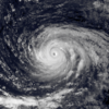


- …that the Joint Typhoon Warning Center considers that Typhoon Vera (pictured) of 1986 is actually two distinct systems, formed from two separated low-level circulations?
- …that Cyclone Freddy (track pictured) in 2023 was the longest-lasting tropical cyclone recorded?
- …that the typhoons of 2024—Yinxing, Toraji, Usagi, and Man-yi (pictured)—made history as the first recorded instance since 1951 of four tropical cyclones coexisting in November?
- …that Hurricane Otis (pictured) in 2023 was the first Pacific hurricane to make landfall at Category 5 intensity and surpassed Hurricane Patricia as the strongest landfalling Pacific hurricane on record?
General images -

The 2016 Atlantic hurricane season was an event in the annual tropical cyclone season in the north Atlantic Ocean. It was the costliest, as well as the first above-average, Atlantic hurricane season since the 2012 season. It featured the highest number of deaths since the 2008 season and also yielded the highest number of named storm landfalls on the United States since that year. The season officially began on June 1 and concluded on November 30, dates which conventionally delimit the period during each year when a majority of tropical cyclones form in the Atlantic Ocean. The season's first cyclone, Alex, developed on January 12, while the final storm of the season, Otto, closed-out the season by exiting into the Eastern Pacific on November 25, becoming the first Atlantic–Pacific crossover hurricane since Hurricane Cesar–Douglas in 1996.
A total of 16 tropical depressions were recorded, of which 15 further intensified into tropical storms. Of those 15, a total of seven strengthened into hurricanes, while four attained their peaks as major hurricanes. Activity began with Alex which, upon making landfall in the Azores, became the first January landfalling tropical cyclone since Hurricane Alice in the 1954 season. In June, tropical storms Colin and Danielle became the earliest third and fourth named storms, respectively, on record. Hermine moved ashore the coastline of Florida as a Category 1 hurricane on September 2, ending the record hurricane drought that began in the state after the 2005 season's Hurricane Wilma. In late September and early October, Hurricane Matthew wrought destruction throughout the Caribbean Sea and Southeastern United States, resulting in $15.09 billion (2016 USD) in damage and 603 deaths. In mid-October, Hurricane Nicole developed to Category 4 intensity and remained a major hurricane while directly impacting Bermuda, the first storm of such strength to do so since Hurricane Fabian in the 2003 season. Following the 2016 season, the names Matthew and Otto were retired from reuse in the North Atlantic by the World Meteorological Organization. (Full article...)
Topics
Subcategories
Related WikiProjects
WikiProject Tropical cyclones is the central point of coordination for Wikipedia's coverage of tropical cyclones. Feel free to help!
WikiProject Weather is the main center point of coordination for Wikipedia's coverage of meteorology in general, and the parent project of WikiProject Tropical cyclones. Three other branches of WikiProject Weather in particular share significant overlaps with WikiProject Tropical cyclones:
- The Non-tropical storms task force coordinates most of Wikipedia's coverage on extratropical cyclones, which tropical cyclones often transition into near the end of their lifespan.
- The Floods task force takes on the scope of flooding events all over the world, with rainfall from tropical cyclones a significant factor in many of them.
- WikiProject Severe weather documents the effects of extreme weather such as tornadoes, which landfalling tropical cyclones can produce.
Things you can do
 |
Here are some tasks awaiting attention:
|
Wikimedia
The following Wikimedia Foundation sister projects provide more on this subject:
-
Commons
Free media repository -
Wikibooks
Free textbooks and manuals -
Wikidata
Free knowledge base -
Wikinews
Free-content news -
Wikiquote
Collection of quotations -
Wikisource
Free-content library -
Wikiversity
Free learning tools -
Wikivoyage
Free travel guide -
Wiktionary
Dictionary and thesaurus


