Pleasant Valley Wildlife Sanctuary
Appearance
| Pleasant Valley Wildlife Sanctuary | |
|---|---|
 | |
 | |
| Type | Wildlife sanctuary |
| Location | 472 West Mountain Road Lenox, Massachusetts, USA |
| Coordinates | 42°22′59″N 73°17′56″W / 42.383°N 73.299°W |
| Area | 1,405 acres (569 ha) |
| Created | 1929 |
| Operated by | Massachusetts Audubon Society |
| Hiking trails | 7 miles |
| Website | Pleasant Valley Wildlife Sanctuary |
Pleasant Valley Wildlife Sanctuary is a 1,405 acres (569 ha) wildlife sanctuary located in Lenox, Massachusetts owned by the Massachusetts Audubon Society. There are 7 miles of trails and a large pond on Yokun Brook. The Overbrook Trail leads to the summit of Lenox Mountain (2126 feet).[1]
Pleasant Valley has an outdoor summer day camp, seasonal special events, and year-round educational programs for preschoolers to adults.[2]
History
[edit]The sanctuary was founded in 1929,[3] when members of the Lenox Garden Club established a new organization, the Pleasant Valley Bird and Wildflower Sanctuary.[4] The first director was Maurice Broun. The sanctuary was acquired by Mass Audubon in 1950.
Gallery
[edit]-
Beaver lodge in pond; Lenox Mountain is at rear
-
Solar Collectors
-
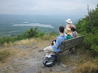
Summit of Lenox Mountain
-
Accessible trail at Pike's Pond
-
Common Yellowthroat near Bluebird Trail
-
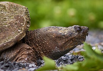
Female Snapping Turtle laying eggs (not visible) near Pike's Pond
-
Snapping turtle laying eggs
-
Yellow Warbler vocalizing
-
Eastern Towhee near Pike's Pond
References
[edit]- ^ Burk, John S. (2021). Massachusetts trail guide : AMC's comprehensive guide to hiking trails in Massachusetts, from the Berkshires to Cape Cod (11th ed.). Boston, Massachusetts. p. 68. ISBN 978-1-62842-130-9.
{{cite book}}: CS1 maint: location missing publisher (link) - ^ "Programs, Classes, & Activities". Massachusetts Audubon. Retrieved 5 June 2021.
- ^ "Pleasant Valley Wildlife Sanctuary Celebrates 90th Anniversary". iBerkshires.com. 31 May 2019. Retrieved 5 June 2021.
- ^ Galluzzo, John J. (2005). Mass Audubon. Arcadia. p. 26. ISBN 0-7385-3782-9.
External links
[edit]Wikimedia Commons has media related to Pleasant Valley Wildlife Sanctuary.


