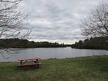
Massasoit State Park
| Massasoit State Park | |
|---|---|
 Middle Pond | |
| Location | Taunton, Bristol, Massachusetts, United States |
| Coordinates | 41°52′04″N 70°59′24″W / 41.86778°N 70.99000°W[1] |
| Area | 1,207 acres (4.88 km2)[2] |
| Elevation | 39 ft (12 m)[1] |
| Established | Unspecified |
| Governing body | Massachusetts Department of Conservation and Recreation |
| Website | Massasoit State Park |
Massasoit State Park is a public recreation area located on the southeast side of the city of Taunton, Massachusetts, with some parklands spilling into the adjacent town of Lakeville. The state park encompasses more than 1200 heavily wooded acres that include six lakes and ponds (Lake Rico, Furnace Pond, King's Pond, Middle Pond, Little Bearhole Pond, and Big Bearhole Pond) and numerous cranberry bogs.[3]
Features
[edit]The park has an extensive trail system for walking, hiking, biking, cross-country skiing, and equestrian use. A launch for non-motorized boats is located at the north end of Lake Rico. A fisherman's landing is found on Big Bearhole Pond. Hunting is available on a restricted basis.[3]
2008 lightning strike
[edit]A lightning strike in 2008 disabled the park's underground electric system, resulting in the closure of much of the park.[4] Interior sections were reopened to vehicular traffic in 2015, with the reopening of the park's 126-site campground in remaining as a long-term goal, according to officials.[5] The park later reopened completely in 2018.[6]
References
[edit]- ^ a b "Middle Pond". Geographic Names Information System. United States Geological Survey, United States Department of the Interior.
- ^ "2012 Acreage Listing" (PDF). Department of Conservation and Recreation. April 2012. Retrieved January 19, 2014.
- ^ a b "Massasoit State Park". MassParks. Executive Office of Energy and Environmental Affairs. Retrieved July 28, 2013.
- ^ Larocque, Marc (January 4, 2011). "Taunton's Massasoit State Park's main road gated until spring". Taunton Daily Gazette. Retrieved February 4, 2013.
- ^ Larocque, Marc (July 8, 2015). "Taunton's Massasoit State Park finally reopens its gates". Enterprise News. Retrieved April 10, 2017.
- ^ Baker-Polito Administration Reopens Massasoit State Park Campground. Retrieved May 20, 2020
External links
[edit]- Massasoit State Park Department of Conservation and Recreation
- Massasoit State Park Trail Map Department of Conservation and Recreation


