
Portal:Scottish islands
The Scottish Islands Portal
Welcome! — Fàilte! — Walcome!
-

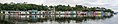
 Seilebost on Harris
 -

-
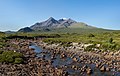
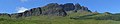
 The Cuillin, Isle of Skye
 -

-
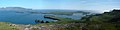
 View from Elgol on the Isle of Skye across to the Cuillin
 -
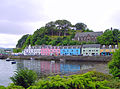
 Portree Waterfront, Isle of Skye
 -
 Looking from the Isle of Mull towards Ardnamurchan peninsula as the Caledonian MacBrayne ferry MV Clansman sails past the Rubha nan Gall lighthouse
 -
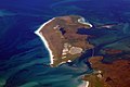
 Tombolo connecting St Ninian's Isle to Mainland, Shetland
 -


Scotland has around 900 offshore islands, most of which are to be found in four main groups: Shetland, Orkney, and the Hebrides, sub-divided into the Inner Hebrides and Outer Hebrides. There are also clusters of islands in the Firth of Clyde, Firth of Forth, and Solway Firth, and numerous small islands within the many bodies of fresh water in Scotland including Loch Lomond and Loch Maree. The largest island is Lewis and Harris, which extends to 2,179 km2 (841 sq mi), and there are a further 200 islands which are greater than 40 hectares (100 acres) in area. Of the remainder, several, such as Staffa and the Flannan Isles, are well-known, despite their small size. Some 94 Scottish islands are permanently inhabited, of which 89 are offshore islands. Between 2001 and 2011, Scottish island populations as a whole grew by 4% to 103,702.
The geology and geomorphology of the islands is varied. Some, such as Skye and Mull, are mountainous, while others like Tiree and Sanday are relatively low-lying. Many have bedrock made from ancient Archaean Lewisian Gneiss which was formed 3 billion years ago; Shapinsay and other Orkney islands are formed from Old Red Sandstone, which is 400 million years old; and others such as Rùm from more recent Tertiary volcanoes. Many of the islands are swept by strong tides, and the Corryvreckan tide race between Scarba and Jura is one of the largest whirlpools in the world. Other strong tides are to be found in the Pentland Firth between mainland Scotland and Orkney, and another example is the "Grey Dog" between Scarba and Lunga. (More on Scottish islands...)
Selected picture
-
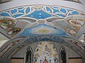 The Italian Chapel on Lamb Holm, Orkney was built from two Nissen huts by Italian prisoners of war during World War 2; the interior frescoes are by Domenico Chiocchetti
Credit: Renata
-

-
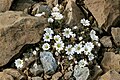 Shetland mouse-ear, a rare plant species unique to Shetland and found only on two serpentine hills in the Keen of Hamar reserve on the island of Unst
Credit: Melvin Grey
-
 Barra Airport is the only one in the world to use a beach as a regular runway
Credit: Steve Houldsworth
-
 The Neolithic farmstead of Knap of Howar on Papa Westray, Orkney, dates from 3700 BC and might be the oldest surviving stone dwelling in northern Europe
Credit: Me677
-
-
 The Bruichladdich distillery, one of eight on Islay; single-malt whisky is a major product of the islands
Credit: Bdcl1881
-
 Alasdair Crotach MacLeod is the first McLeod not to be buried on Iona; his tomb on Harris dates from 1528, and is among the finest of this period in Scotland
Credit: Gvdwiele
-
 The tied island of St Ninian's Isle is joined to the Shetland Mainland by the largest tombolo in the UK
Credit: ThoWi
-
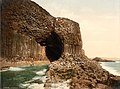
 The cliffs of Eshaness, North Mainland, Shetland
Credit: ThoWi
-
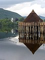
 Blackhouses were the traditional form of house across the Hebrides and the Highlands; this example is at Arnol, Lewis
Credit: LornaMCampbell
-

-

-
-
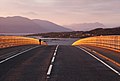 Skye Bridge, opened in 1995; the toll was lifted in 2004
Credit: Gene Selkov
-
-
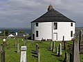 Kilarrow Parish Church, known as the Round Church, is a Georgian building in Bowmore on Islay
Credit: Ronsteenvoorden
-
-
 Rubha nan Gall lighthouse, Tobermory, Mull, built in 1857 by David and Thomas Stevenson, with a Caledonian MacBrayne ferry in the background
Credit: Colin
-
 The Corryvreckan Whirlpool in the narrow Gulf of Corryvreckan between Jura and Scarba
Credit: Walter Baxter
-

-
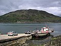
 Baile Mòr, the village on Iona
Credit: Clydecoast
-
 Aerial view of the ruins of a hermitage on Canna
Credit: Peter Van den Bossche
-
-
 White-tailed eagle fishing off Mull, one of several islands to which the birds have been successfully re-introduced
Credit: Jacob Spinks
-
-

-
 The 1st-century Dun Carloway on Lewis is a well-preserved example of an Iron Age broch, a type of complex Atlantic roundhouse only found in Scotland
Credit: Morris R. Maciver
-
 Neist Point Lighthouse on Skye was designed by David Alan Stevenson and dates from 1909
Credit: Lionel Ulmer
-
-
 Eilean Donan Castle at the confluence of three sea lochs, Loch Duich, Loch Long and Loch Alsh
Credit: Diliff
-
-
 The ferry from Glenelg to Kylerhea on Skye has run for 400 years; the present boat, MV Glenachulish, is the only hand-operated turntable ferry still in operation
Credit: Wojsyl
-

-

-
 Duart Castle, a 13th-century castle on Mull, the historical seat of Clan Maclean
Credit: Philippe Giabbanelli
-
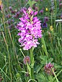
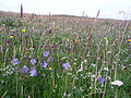 Wildflowers in machair, a coastal dune grassland found in the Outer Hebrides and elsewhere
Credit: Jon Thomson


.jpg)


.jpg)


.jpg)

.jpg)
.jpg)


_2.jpg)


Selected island group

The Hebrides (/ˈhɛbrɪdiːz/ HEB-rid-eez; Scottish Gaelic: Innse Gall, pronounced [ˈĩːʃə ˈkaul̪ˠ]; Old Norse: Suðreyjar, lit. 'Southern isles') are an archipelago off the west coast of the Scottish mainland. The islands fall into two main groups, based on their proximity to the mainland: the Inner and Outer Hebrides.
These islands have a long history of occupation (dating back to the Mesolithic period), and the culture of the inhabitants has been successively influenced by the cultures of Celtic-speaking, Norse-speaking, and English-speaking peoples. This diversity is reflected in the various names given to the islands, which are derived from the different languages that have been spoken there at various points in their history.
The Hebrides are where much of Scottish Gaelic literature and Gaelic music has historically originated. Today, the economy of the islands is dependent on crofting, fishing, tourism, the oil industry, and renewable energy. The Hebrides have less biodiversity than mainland Scotland, but a significant number of seals and seabirds.
The islands have a combined area of 7,285 km2 (2,813 sq mi), and, as of 2011[update], a combined population of around 45,000. (Full article...)
News

- 12 February: The BiFab construction yard at Arnish near Stornoway, Isle of Lewis, is purchased by InfraStrata.
- 11 February: Wild fires occur in Benbecula; and at Achmore and Sildinish in the Isle of Lewis; Horsaclete in Harris; Brevig in Barra; and Eubhal in North Uist.
- 19 January: Barra and Vatersay are put under tier-4 restrictions after an outbreak of Covid-19.
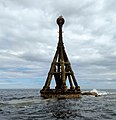
- 18 January: The Shetland Space Centre submits plans for a spaceport on Unst (proposed site pictured), Shetland, including three rocket launch pads.
- 8 January: Distilleries in Orkney and South Uist receive government grants to research ways of reducing their CO2 emissions.
- 4 January: After the UK leaves the European Union, the Northern Celt, an Irish fishing boat based out of Greencastle, County Donegal, is ordered to leave the 12-nautical-mile zone around Rockall by officers of Marine Scotland.
- 1 January: A total of 72 cases of Covid-19 are recorded in an ongoing outbreak in Shetland.
- 9 December: A review by a committee of MSPs into the commissioning and building of two new dual-fuel Caledonian MacBrayne ferries, MV Glen Sannox and "hull 802", criticises CMAL, Transport Scotland and the Scottish government, as well as the ship builders, Ferguson Marine.
- 3 December: North-east Lewis, Sea of the Hebrides and Shiant East Bank are designated Marine Protected Areas, while East Mainland Coast Shetland, Sound of Gigha, Coll and Tiree, Rùm, the west coast of the Outer Hebrides, and the waters off St Kilda and Foula are designated Special Protection Areas.
- 30 November: Michael Russell, MSP for Argyll and Bute, and David Stewart and John Finnie, MSPs for the Highlands and Islands region, will stand down at the 2021 election.
- 17 November: Phytophthora ramorum-infected larch trees in Arran are to be felled over a 543-acre area, to prevent the fungus-like pathogen from spreading.
- 4 November: The Scottish Wildlife Trust objects to a proposed salmon farm in the Marine Protected Area of Wester Ross, near Horse Island, Summer Isles, because of the potential impact on kelp forests and maerl beds.
Selected fauna

The Boreray, also known as the Boreray Blackface or Hebridean Blackface, is a breed of sheep originating on the St Kilda archipelago off the west coast of Scotland and surviving as a feral animal on one of the islands, Boreray. The breed was once reared for meat and wool, but is now used mainly for conservation grazing. The Boreray is one of the Northern European short-tailed sheep group of breeds.
It is one of the rarest breeds of sheep in the United Kingdom. The breed is classed as "Category 3: Vulnerable" by the Rare Breeds Survival Trust, because 500–900 breeding ewes are known to exist. It had previously been the only breed classed in "Category 2: Critical" but by 2017 the population had grown. (Full article...)
Selected history & culture article

Description of the Western Isles of Scotland is the oldest known account of the Hebrides and the Islands of the Clyde, two chains of islands off the west coast of Scotland. The author was Donald Monro, a clergyman who used the title of "Dean of the Isles" and who lived through the Scottish Reformation. Monro wrote the original manuscript in 1549, although it was not published in any form until 1582 and was not widely available to the public in its original form until 1774. A more complete version, based on a late 17th-century manuscript written by Sir Robert Sibbald, was first published as late as 1961. Monro wrote in Scots and some of the descriptions are difficult for modern readers to render into English. Although Monro was criticised for publishing folklore and for omitting detail about the affairs of the churches in his diocese, Monro's Description is a valuable historical account and has reappeared in part or in whole in numerous publications, remaining one of the most widely quoted publications about the western islands of Scotland.
Monro also wrote a brief description of the five main branches of Clan Donald that existed in his day under the title "The Genealogies Of The Chief Clans Of The Iles", and this work was included when Description was first published as a stand-alone volume in 1805. The Sibbald manuscript also contains details about the "Council of the Isles" that operated from Eilean na Comhairle in Loch Finlaggan on the island of Islay. This is the most detailed extant account of the supreme judiciary body that had existed under the Lordship of the Isles until its demise in the late fifteenth century. (Full article...)
Selected island

Eday (/ˈiːdiː/, Scots: Aidee) is one of the islands of Orkney, which are located to the north of the Scottish mainland. One of the North Isles, Eday is about 24 kilometres (13 nautical miles) from the Orkney Mainland. With an area of 27 km2 (10 sq mi), it is the ninth-largest island of the archipelago. The bedrock of the island is Old Red Sandstone, which is exposed along the sea-cliffs.
There are various well-preserved Neolithic tombs, as well as evidence of Bronze Age settlement and the remains of a Norse-era castle. During the period of Scottish rule the substantial property of Carrick House was developed at Calfsound, which became a burgh for a short period. During the British era many agricultural improvements were introduced, although there has been a substantial decline in the population since the mid-nineteenth century. In the twenty-first century the Eday Partnership has had success in promoting the island's economy. Local placenames reflect the diverse linguistic heritage and the landscapes of the island and its surrounding seas attract abundant wildlife. (Full article...)
Did you know?

- ... that on Stac an Armin, the highest stack in Scotland, the last great auk (portrayal pictured) in the British Isles was clubbed to death in 1840 because it was thought to be a witch?
- ... that "The Summons" includes 13 questions asked in the voice of Jesus?
- ... that a 19th century antiquary considered that a saga character named Ljótólfr was the eponymous ancestor of the Clan MacLeod?
- ... that the stoor worm, a sea monster of Orcadian mythology, could destroy humans with its putrid breath?
Selected portrait
-
 Columba was a 6th-century Irish-born saint who spread Christianity in Scotland and founded Iona Abbey, where he is commemorated in this stained-glass window
Credit: Vegansoldier
-
-
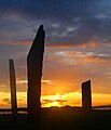 The Standing Stones of Stenness, near Stromness, Orkney, started by 3100 BC and possibly Britain's oldest henge site
Credit: Fantoman400
-
 The North Carr Beacon at low tide; the unlit beacon was built between 1813 and 1821 by Robert Stevenson to warn shipping of the North Carr Reef near Fife Ness
Credit: Kathrinpassig
-
-
 Puffins and guillemots on Lunga in the Treshnish Isles, with Bac Mòr (known as Dutchman's Cap for its distinctive shape) in the background
Credit: Simaron
-
-

-
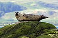
 Seals hauled out by Lyrie Geo on Hoy
Credit: Claire Pegrum
-

-
 Scottish Gaelic speakers in the 2011 census; the Outer Hebrides, Tiree, Raasay, Skye and Lismore have the highest proportion of speakers
Credit: SkateTier
-

-
 The 8th-century Kildalton Cross, Islay, one of the best-preserved Celtic crosses in Scotland
Credit: Tom Richardson


Selected geography article

Trotternish (Scottish Gaelic: Tròndairnis) is the northernmost peninsula of the Isle of Skye in Scotland, spanning in length from Portree to Rubha Hunish. The Trotternish escarpment runs almost the full length of the peninsula, some 30 kilometres (20 miles), and contains landmarks such as the Old Man of Storr and the Quiraing. The summit of The Storr, overlooking the Old Man, is the highest point of the peninsula at 719 m above sea level. The north-eastern part of the peninsula around Quiraing is designated as a National Scenic Area and the entire escarpment is a Special Area of Conservation.
Dinosaur footprints have been found at An Corran, which is also a Mesolithic hunter-gatherer site dating to the 7th millennium BC. The ruins of the 14th–15th-century Duntulm Castle stand at the northern end of the peninsula.
The three major settlements on Trotternish are Portree, generally regarded as the capital of Skye, Uig, a ferry terminus, and the township of Staffin. Trotternish is the strongest Gaelic-speaking area of Skye. (Full article...)
Selected biography

Columba (/kəˈlʌmbəˌ ˈkɒlʌmbə/) or Colmcille (7 December 521 – 9 June 597 AD) was an Irish abbot and missionary evangelist credited with spreading Christianity in what is today Scotland at the start of the Hiberno-Scottish mission. He founded the important abbey on Iona, which became a dominant religious and political institution in the region for centuries. He is the patron saint of Derry. He was highly regarded by both the Gaels of Dál Riata and the Picts, and is remembered today as a Catholic saint and one of the Twelve Apostles of Ireland.
Columba studied under some of Ireland's most prominent church figures and founded several monasteries in the country. Around 563 AD he and his twelve companions crossed to Dunaverty near Southend, Argyll, in Kintyre before settling in Iona in Scotland, then part of the Ulster kingdom of Dál Riata, where they founded a new abbey as a base for spreading Celtic Christianity among the pagan Northern Pictish kingdoms. He remained active in Irish politics, though he spent most of the remainder of his life in Scotland. Three surviving early-medieval Latin hymns are attributed to him. (Full article...)
Related portals
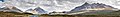
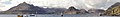
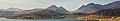
Selected panorama
-
-
-
-

-

-
-
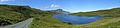
 Eilean Donan
Credit: Stefan Krause
-
 Small freshwater islets on Loch Assynt
Credit: Vincent
-

-

-

-
 Iona Abbey
Credit: Oliver-Bonjoch

Topics
|  | ||||||||||||||||
|
| |||||||||||||||||
| |||||||||||||||||
| |||||||||||||||||
| |||||||||||||||||
| |||||||||||||||||
| |||||||||||||||||
| |||||||||||||||||
Categories
The main category is Islands of Scotland, with subcategories

Things you can do
- Add new articles to the project by placing {{WPSI|class=|importance=}} on the talk page
- Add a link to the portal in the "See also" section of relevant articles with {{Portal|Scottish islands}}
- Take requested photographs or create requested pages, including Prehistoric Hebrides, Trialabreac, Dog Isle...
- Expand a Scottish Islands stub into a full article, adding images, citations, references and infoboxes; did you know that if you expand one 5x, you can nominate it for Did You Know?
- Improve one of the highest priority articles, including Mull, Bute, North & South Uist, Columba, Highland Clearances, Sorley MacLean, St Magnus Cathedral...
- Follow these hints to improve a B-class article and nominate it for Good Article

- Suggest articles, pictures, interesting facts, events and news to be featured here on the portal
Wikiproject

Associated Wikimedia
The following Wikimedia Foundation sister projects provide more on this subject:
-
 Commons
Free media repository -
 Wikibooks
Free textbooks and manuals -
 Wikidata
Free knowledge base -
 Wikinews
Free-content news -
 Wikiquote
Collection of quotations -
 Wikisource
Free-content library -
 Wikiversity
Free learning tools -
 Wikivoyage
Free travel guide -
 Wiktionary
Dictionary and thesaurus


