Kawaikini
| Kawaikini | |
|---|---|
| Mount Waialeale | |
 | |
| Highest point | |
| Elevation | 5,243 ft (1,598 m)[1] |
| Prominence | 5,243 ft (1,598 m)[1] |
| Listing | |
| Coordinates | 22°03′24″N 159°29′48″W / 22.05667°N 159.49667°W[2] |
| Geography | |
| Location | Kauai County, Hawaii, United States |
| Parent range | Hawaiian Islands |
| Geology | |
| Mountain type | |
| Volcanic arc/belt | Hawaiian–Emperor seamount chain |
| Climbing | |
| First ascent | Ancient Hawaiians (Unknown Time) |
| Easiest route | Mountaineering Trek |
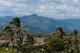
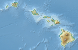
Kawaikini is a shield volcano on the Hawaiian Island of Kauai and in Kauai County and measures 5,243 feet (1,598 m) in elevation.[2] It is the summit of the island's inactive central shield volcano, Mount Waialeale.[3] Other peaks on Kauai include: Waialeale (5,148 feet), Namolokama Mountain (4,421 feet), Kalalau Lookout (4,120 feet), Keanapuka Mountain (4,120 feet), Haupu (2,297 feet) and Nounou (1,241 feet).[4]
Description
[edit]A rain gauge placed on the nearby Waialeale lake records daily rainfall[5] and regularly lands Kauai's peaks on the National Climatic Data Center's list of places averaging the highest annual rainfall.[6] This high rainfall makes reaching the summit difficult on most days.
The rain is not the only barrier to reaching Kawaikini. The Alakai Wilderness Preserve is located to the west and its miles of dense, swampy forest limit access to the summit. To the north, east, and south, Kawaikini is protected by steep, wet cliffs.[7]
Etymology
[edit]Ka wai kini literally translates to "the multitudinous water" in the Hawaiian language, referring to the island's high rainfall.[8]
See also
[edit]- List of mountain peaks of the United States
- List of Ultras of Oceania
- List of Ultras of the United States
- Hawaii hotspot
- Evolution of Hawaiian volcanoes
- Hawaiian–Emperor seamount chain
References
[edit]- ^ a b "Alaska & Hawaii P1500s - the Ultras" Peaklist.org. Retrieved 2012-10-26.
- ^ a b U.S. Geological Survey Geographic Names Information System: Kawaikini
- ^ "Climbing Mount Waialeale and Kawaikini". Archived from the original on November 8, 2010. Retrieved April 2, 2011.
- ^ "Section 5". Archived from the original on October 6, 2011. Retrieved April 2, 2011.
- ^ "USGS Current Conditions for USGS 220427159300201 1047.0 Mt. Waialeale Rain Gage nr Lihue, Kauai, HI".
- ^ "NCDC: Global Measured Extremes of Temperature and Precipitation". www0.ncdc.noaa.gov. Archived from the original on September 27, 2002. Retrieved June 6, 2022.
- ^ Nelson, D., et al. (2006). The Conquest of Kauai - Five Days to Kawaikini. (www.cohp.org/hi/Kauai_2.pdf)
- ^ Mary Kawena Pukui; Samuel Hoyt Elbert; Esther T. Mookini (2004). "lookup of Kawaikini ". in Place Names of Hawai'i. Ulukau, the Hawaiian Electronic Library, University of Hawaii Press. Retrieved April 3, 2011.

