Kurrah
Kurrah Dildarnagar
Tajpur Usmanabad | |
|---|---|
village | |
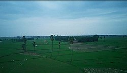
 Lawishely Green farms of Tajpur Kurrah village during Monsoon. | |
| Nickname: Coconut village of the North India | |
| Coordinates: 25°23′15″N 83°41′17″E / 25.3876048°N 83.6880159°E | |
| Country | |
| State | Uttar Pradesh |
| District | Ghazipur |
| Established | 1570 |
| Founded by | Zamindar Usman khan |
| Government | |
| • Body | Gram panchayat |
| Area | |
• Total | 450.34 ha (1,112.81 acres) |
| • Land | 440.025 ha (1,087.325 acres) |
| • Water | 10.315 ha (25.489 acres) |
| Population (2011) | |
• Total | 7,368 |
| • Density | 1,600/km2 (4,200/sq mi) |
| Languages | |
| • Official | Hindi |
| Time zone | UTC+5:30 (IST) |
Kurrah or Tajpur Kurrah is a village in Dildarnagar Kamsar region of Zamania tehsil in Ghazipur district. It is avillage of pathan Kamsaari pathans in the Indian state of Uttar Pradesh. Almost 3900 Kamsaar Pathans lived in the village as of 2011.[1][2]
History
[edit]The Tajpur kurrah village was founded by Zamindar Usman khan a son of Narhar Khan founder of kamsar pathans and founder of Dildarnagar kamsar. Before Usman established this village his father Narhar Khan lived at a place in village name as Kamesardih. According to the old records of village it is said the village would be founded in late 1500 ADs. Later one of Usman's descendants shifted to Bihar and established Akhini village in Bihar state of India. On the banks of Karmanasa river.[3]
Agriculture
[edit]The village is situated at the banks of durgavati and karamnasa river and have good crop producing soil.

The Karamanasa river passes 3.2 kilometer from the village. The total area of the village is 1112 acres out of which the total crop production area of the village is 1000 acres. A variety of crops grow in Purvanchal and Bihar. The village has tractors, harvester etc. The village also have one Eidgah.

As of 2011 census, the main population of the village lives in an area of 111 acres with the total number of 976 house holds.[4]
Historical population
[edit]| Year | Pop. | ±% |
|---|---|---|
| 1861 | 2,535 | — |
| 1871 | 2,788 | +10.0% |
| 1881 | 3,066 | +10.0% |
| 1891 | 3,374 | +10.0% |
| 1901 | 3,712 | +10.0% |
| 1911 | 4,082 | +10.0% |
| 1921 | 4,490 | +10.0% |
| 1931 | 4,940 | +10.0% |
| 1941 | 5,435 | +10.0% |
| 1951 | 5,434 | −0.0% |
| 1961 | 5,400 | −0.6% |
| 1971 | 5,940 | +10.0% |
| 1981 | 6,534 | +10.0% |
| 1991 | 7,100 | +8.7% |
| 2001 | 6,910 | −2.7% |
| 2011 | 7,316 | +5.9% |
| Source:Census of India[5][6][7] | ||
Dr irshad khan Dr nawaz khan Dr tarannum khan Drx nusrat khan
References
[edit]- ^ "Bhulekh".
- ^ "2011 census of India".
- ^ Ansari, Saiyad Hasan (27 September 1986). "Evolution and Spatial organisation of clan settlements in Middle Ganga Valley". New Delhi: Concept Publishing Company.
- ^ "Bhulekh".
- ^ "Census of India". mospi.gov.in. Archived from the original on 13 August 2008. Retrieved 23 June 2008.
- ^ "2011 census of India".
- ^ "Historical Census of India". Archived from the original on 17 February 2013. Retrieved 5 November 2015.

