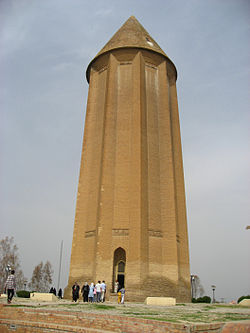
Gonbad-e Kavus County
Gonbad-e Kavus County
Persian: شهرستان گنبد کاووس | |
|---|---|
 | |
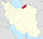
 Location of Gonbad-e Kavus County in Golestan province (top, yellow) | |
 Location of Golestan province in Iran | |
| Coordinates: 37°35′N 55°04′E / 37.583°N 55.067°E[1] | |
| Country | |
| Province | Golestan |
| Capital | Gonbad-e Kavus |
| Districts | Central, Dashli Borun |
| Population (2016)[2] | |
• Total | 348,744 |
| Time zone | UTC+3:30 (IRST) |
| Gonbad-e Kavus County at GEOnet Names Server | |
Gonbad-e Kavus County (Persian: شهرستان گنبد کاووس) is in Golestan province, Iran. Its capital is the city of Gonbad-e Kavus.[3]
History
[edit]Formerly called Gorgan or Jorjan, because of the ruins of the historical city called Gorgan, the capital of the Ziyarid dynasty, in its southwest corner. It was called Hyrcania in ancient times. Its capital city was founded by German engineers and architects with high urban engineering standards, by the order of Reza Pahlavi.[citation needed]
History
[edit]After the 2016 National Census, the village of Korand was elevated to the status of a city.[4]
Demographics
[edit]Population
[edit]At the time of the 2006 census, the county's population was 283,331 in 63,482 households.[5] The following census in 2011 counted 325,789 people in 83,369 households.[6] The 2016 census measured the population of the county as 348,744 in 97,147 households.[2]
Administrative divisions
[edit]Gonbad-e Kavus County's population history and administrative structure over three consecutive censuses are shown in the following table.
| Administrative Divisions | 2006[5] | 2011[6] | 2016[2] |
|---|---|---|---|
| Central District | 261,492 | 300,846 | 320,894 |
| Aqabad RD | 29,707 | 32,907 | 36,886 |
| Bagheli-ye Marama RD | 33,148 | 34,077 | 35,771 |
| Fajr RD | 40,672 | 50,678 | 52,923 |
| Soltanali RD | 30,798 | 38,638 | 43,404 |
| Gonbad-e Kavus (city) | 127,167 | 144,546 | 151,910 |
| Dashli Borun District | 21,839 | 24,197 | 27,181 |
| Atrak RD | 12,468 | 13,405 | 15,244 |
| Kerend RD | 7,607 | 8,511 | 9,443 |
| Incheh Borun (city) | 1,764 | 2,281 | 2,494 |
| Korand (city)[a] | |||
| Total | 283,331 | 325,789 | 348,744 |
| RD = Rural District | |||
See also
[edit]![]() Media related to Gonbad-e Kavus County at Wikimedia Commons
Media related to Gonbad-e Kavus County at Wikimedia Commons
Notes
[edit]References
[edit]- ^ OpenStreetMap contributors (17 October 2024). "Gonbad-e Kavus County" (Map). OpenStreetMap (in Persian). Retrieved 17 October 2024.
- ^ a b c Census of the Islamic Republic of Iran, 1395 (2016): Golestan Province. amar.org.ir (Report) (in Persian). The Statistical Center of Iran. Archived from the original (Excel) on 29 March 2019. Retrieved 19 December 2022.
- ^ Habibi, Hassan (c. 2024) [Approved 21 June 1369]. Approval of the organization and chain of citizenship of the elements and units of the divisions of Mazandaran province, centered in Sari city. lamtakam.com (Report) (in Persian). Ministry of the Interior, Defense Political Commission of the Government Council. Subject Letter 3233.1.5.53; Notification 83346/T144K. Archived from the original on 14 January 2024. Retrieved 14 January 2024 – via Lam ta Kam.
- ^ a b Jahangiri, Ishaq (26 September 2021) [Approved 28 April 1400]. Letter of approval regarding national divisions in Gonbad-e Kavus County, Golestan province. sdil.ac.ir (Report) (in Persian). Ministry of the Interior, Council of Ministers. Proposal 175409; Notification 46286/T58438AH. Archived from the original on 28 March 2023. Retrieved 17 October 2024 – via Shahr Danesh Legal Research Institute.
- ^ a b Census of the Islamic Republic of Iran, 1385 (2006): Golestan Province. amar.org.ir (Report) (in Persian). The Statistical Center of Iran. Archived from the original (Excel) on 20 September 2011. Retrieved 25 September 2022.
- ^ a b Census of the Islamic Republic of Iran, 1390 (2011): Golestan Province. irandataportal.syr.edu (Report) (in Persian). The Statistical Center of Iran. Archived from the original (Excel) on 17 January 2023. Retrieved 19 December 2022 – via Iran Data Portal, Syracuse University.

