Dowreh County
Appearance
Dowreh County
Persian: شهرستان دوره Chegeni County شهرستان چگنی | |
|---|---|
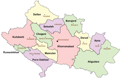
 Location of Dowreh (Chegeni) County in Lorestan province (center left, green) | |
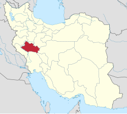
 Location of Lorestan province in Iran | |
| Coordinates: 33°36′N 47°56′E / 33.600°N 47.933°E[1] | |
| Country | Iran |
| Province | Lorestan |
| Capital | Sarab-e Dowreh |
| Districts | Central, Shahivand, Veysian |
| Population (2016)[2] | |
• Total | 41,756 |
| Time zone | UTC+3:30 (IRST) |
Dowreh County (Persian: شهرستان دوره)[a][3] is in Lorestan province, Iran. Its capital is the city of Sarab-e Dowreh.[4]
History
[edit]After the 2006 National Census, Dowreh-e Chegeni and Veysian Districts were separated from Khorramabad County in the establishment of Dowreh County, which was divided into three districts of two rural districts each, with Sarab-e Dowreh as its capital.[4]
Demographics
[edit]Population
[edit]At the time of the 2011 census, the county's population was 43,221 people in 10,819 households.[5] The 2016 census measured the population of the county as 41,756 in 11,948 households.[2]
Administrative divisions
[edit]Dowreh County's population history and administrative structure over two consecutive censuses are shown in the following table.
| Administrative Divisions | 2011[5] | 2016[2] |
|---|---|---|
| Central District | 16,190 | 15,624 |
| Dowreh RD | 9,444 | 8,907 |
| Teshkan RD | 5,231 | 5,004 |
| Sarab-e Dowreh (city) | 1,515 | 1,713 |
| Shahivand District | 14,824 | 14,851 |
| Kashkan-e Jonubi RD | 6,496 | 6,379 |
| Kashkan-e Shomali RD[b] | 8,328 | 8,472 |
| Veysian District | 12,198 | 11,281 |
| Shurab RD | 4,413 | 4,251 |
| Veysian RD | 5,797 | 4,943 |
| Veysian (city)[c] | 1,988 | 2,087 |
| Total | 43,221 | 41,756 |
| RD = Rural District | ||
See also
[edit]![]() Media related to Dowreh County at Wikimedia Commons
Media related to Dowreh County at Wikimedia Commons
Notes
[edit]References
[edit]- ^ OpenStreetMap contributors (24 August 2023). "Dowreh County" (Map). OpenStreetMap (in Persian). Retrieved 24 August 2023.
- ^ a b c "Census of the Islamic Republic of Iran, 1395 (2016)". AMAR (in Persian). The Statistical Center of Iran. p. 15. Archived from the original (Excel) on 12 October 2020. Retrieved 19 December 2022.
- ^ "تاريخچه شهرستان - موقعيت جغرافيايي شهرستان چگني" [History of city - Geographical location Chegeni County:] (in Persian). Lorestan province. Archived from the original on 29 September 2015.
- ^ a b c d Davodi, Parviz (29 July 1386). "Approval letter regarding the reforms of country divisions in Lorestan province". DOTIC (Laws and Regulations Portal of the Islamic Republic of Iran) (in Persian). Ministry of Interior, Cabinet of Ministers. Archived from the original on 29 September 2015. Retrieved 24 August 2023.
- ^ a b "Census of the Islamic Republic of Iran, 1390 (2011)". Syracuse University (in Persian). The Statistical Center of Iran. p. 15. Archived from the original (Excel) on 19 January 2023. Retrieved 19 December 2022.

