Basaidu
Basaidu
Persian: باسعيدو | |
|---|---|
Village | |
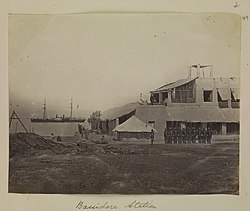
 Indian troops parade at Bassidore (Basaidu) Station, circa 1870 | |
| Coordinates: 26°38′57″N 55°17′09″E / 26.64917°N 55.28583°E[1] | |
| Country | Iran |
| Province | Hormozgan |
| County | Qeshm |
| District | Hara |
| Rural District | Dulab |
| Population (2016)[2] | |
• Total | 2,228 |
| Time zone | UTC+3:30 (IRST) |
Basaidu (Persian: باسعيدو)[a] is a village in Dulab Rural District of Hara District, Qeshm County, Hormozgan province, Iran.
Etymology
[edit]Despite phonetic similarity, Basaidu is not derived from the dynastic name of the Bu Saidi sultans of Oman who in fact ruled Qeshm Island and vicinity until the mid 19th century. Instead, the name is the ancient Greek/Hellenistic Poseidonia, named after the sea god, Poseidon. Further up the Persian Gulf, ports of Apollonia (Obolla) and Apollodorus (Abadan), among others, likewise carry ancient Hellenistic names.[citation needed]
Demographics
[edit]Population
[edit]At the time of the 2006 National Census, the village's population was 1,662 in 359 households, when it was in Shahab District.[4] The following census in 2011 counted 1,989 people in 465 households.[5] The 2016 census measured the population of the village as 2,228 people in 520 households. It was the most populous village in its rural district.[2]
In 2017, the rural district was separated from the district in the formation of Hara District.[6]
See also
[edit]Notes
[edit]References
[edit]- ^ OpenStreetMap contributors (19 November 2024). "Basaidu, Qeshm County" (Map). OpenStreetMap (in Persian). Retrieved 19 November 2024.
- ^ a b Census of the Islamic Republic of Iran, 1395 (2016): Hormozgan Province. amar.org.ir (Report) (in Persian). The Statistical Center of Iran. Archived from the original (Excel) on 5 May 2022. Retrieved 19 December 2022.
- ^ Basaidu can be found at GEOnet Names Server, at this link, by opening the Advanced Search box, entering "-3055681" in the "Unique Feature Id" form, and clicking on "Search Database".
- ^ Census of the Islamic Republic of Iran, 1385 (2006): Hormozgan Province. amar.org.ir (Report) (in Persian). The Statistical Center of Iran. Archived from the original (Excel) on 20 September 2011. Retrieved 25 September 2022.
- ^ Census of the Islamic Republic of Iran, 1390 (2011): Hormozgan Province. irandataportal.syr.edu (Report) (in Persian). The Statistical Center of Iran. Archived from the original (Excel) on 17 January 2023. Retrieved 19 December 2022 – via Iran Data Portal, Syracuse University.
- ^ Jahangiri, Ishaq (5 December 2018) [Approved 27 August 1397]. Approval regarding the establishment of the Hara District under the jurisdiction of Qeshm County, Hormozgan province. sdil.ac.ir (Report) (in Persian). Ministry of the Interior, Cabinet of Ministers. Proposal 127630; Notification 107785/T55047AH. Archived from the original on 22 March 2023. Retrieved 28 January 2025 – via Shahr Danesh Legal Research Institute.


