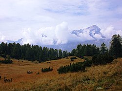
Zoldo Alto
Appearance
Zoldo Alto | |
|---|---|
 | |
| Coordinates: 46°22′31″N 12°7′35″E / 46.37528°N 12.12639°E | |
| Country | Italy |
| Region | Veneto |
| Province | Belluno (BL) |
| Comune | Val di Zoldo |
| Area | |
• Total | 619 km2 (239 sq mi) |
| Elevation | 1,177 m (3,862 ft) |
| Population | |
• Total | 1,183 |
| • Density | 1.9/km2 (4.9/sq mi) |
| Demonym | Zoldani |
| Time zone | UTC+1 (CET) |
| • Summer (DST) | UTC+2 (CEST) |
| Postal code | 32010 |
| Dialing code | 0437 |
| Patron saint | San Nicolò |
| Saint day | 6 December |
| Website | Official website |
Zoldo Alto is a town in the province of Belluno, Veneto, Italy. It has been a frazione of Val di Zoldo since 2016. It is noted for its ski resort. A boarding school was established in the 1950s, used by the children during spring and autumn and senior citizens during the winter months.[2] On 31 January 1991 the municipality was affected by the Ru Duelle Roe landslide, which affected the right flank of the Ru delle Roe stream in the dolomitic slopes of Cime di San Sebastiano and Moiazza.[3] The region is a producer of fresh and mature cheeses.[4]
References
[edit]- ^ All demographics and other statistics from the Italian statistical institute (Istat)
- ^ Lubinski, Christina; Fear, Jeffrey; Pérez, Paloma Fernández (18 July 2013). Family Multinationals: Entrepreneurship, Governance, and Pathways to Internationalization. Routledge. p. 1. ISBN 978-1-135-04492-3.
- ^ Casale, Riccardo; Margottini, Claudio (1 January 1999). Floods and Landslides: Integrated Risk Assessment: Integrated Risk Assessment ; with 30 Tables. Springer Science & Business Media. p. 298. ISBN 978-3-540-64981-6.
- ^ The Italian Food Guide: The Ultimate Guide to the Regional Foods of Italy. Touring Editore. 2002. p. 171. ISBN 978-88-365-2538-6.
External links
[edit]Wikimedia Commons has media related to Zoldo Alto.

