Zgornji Duplek
Appearance
Zgornji Duplek | |
|---|---|
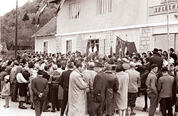
 Plaque unveiling ceremony in Zgornji Duplek in 1960 | |
| Coordinates: 46°30′33.21″N 15°43′57.85″E / 46.5092250°N 15.7327361°E | |
| Country | |
| Traditional region | Styria |
| Statistical region | Drava |
| Municipality | Duplek |
| Area | |
• Total | 6.54 km2 (2.53 sq mi) |
| Elevation | 248.9 m (816.6 ft) |
| Population (2020) | |
• Total | 1,824 |
| • Density | 280/km2 (720/sq mi) |
| [1] | |
Zgornji Duplek (pronounced [ˈzɡoːɾnji ˈduːplɛk]) is a settlement in the Municipality of Duplek in northeastern Slovenia. It lies on the left bank of the Drava River southeast of Maribor. The area is part of the traditional region of Styria. The municipality is now included in the Drava Statistical Region.[2]
An 8th- to 9th-century Slavic burial ground with signs of pre-Christian burial rituals has been identified near the settlement.[3]
References
[edit]- ^ Statistical Office of the Republic of Slovenia Archived November 18, 2008, at the Wayback Machine
- ^ Duplek municipal site
- ^ Slovenian Ministry of Culture register of national heritage Archived July 12, 2010, at the Wayback Machine reference number ešd 8984
External links
[edit] Media related to Zgornji Duplek at Wikimedia Commons
- Zgornji Duplek on Geopedia


