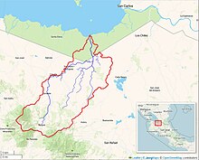
Zapote River (Costa Rica)
Appearance
| Zapote River | |
|---|---|
 Rio Zapote watershed (Interactive map) | |
| Location | |
| Country | Costa Rica |
| Physical characteristics | |
| Source | Quebrada Zapotillo, south of Zapote, Costa Rica |
| • coordinates | 10°45′N 85°05′W / 10.75°N 85.08°W |
| Mouth | |
• location | Lake Nicaragua near Punta El Diablo |
• coordinates | 11°02′10″N 84°53′28″W / 11.036°N 84.891°W |
| Basin size | 590 km² |
Zapote River (Spanish pronunciation: [saˈpote]) is a river of Costa Rica.[1]
References
[edit]- ^ Instituto Costarricense de Turismo map, 2007. (in Spanish)
