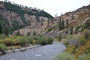
Wallowa Lake Highway Forest State Scenic Corridor
Tools
Actions
General
Print/export
In other projects
Appearance
From Wikipedia, the free encyclopedia
State park in Oregon, USA
| Wallowa Lake Highway Forest State Scenic Corridor | |
|---|---|
 Oregon State Parks | |
 | |
| Type | State park |
| Location | Wallowa County, Oregon |
| Nearest city | La Grande |
| Coordinates | 45°37′22″N 117°41′07″W / 45.6226446°N 117.685197°W / 45.6226446; -117.685197[1] |
| Operated by | Oregon Parks and Recreation Department |
Wallowa Lake Highway Forest State Scenic Corridor is a state park in the U.S. state of Oregon, administered by the Oregon Parks and Recreation Department.
See also
[edit]References
[edit]External links
[edit]- "Wallowa Lake Highway Forest State Scenic Corridor". Oregon Parks and Recreation Department. Retrieved June 23, 2011.
This Wallowa County, Oregon state location article is a stub. You can help Wikipedia by expanding it. |
