Waipu District
Appearance
24°19′47.5″N 120°39′14.8″E / 24.329861°N 120.654111°E
Waipu
外埔區 | |
|---|---|
| Waipu District | |
 | |
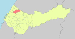
 Waipu District in Taichung City | |
| Location | Taichung, Taiwan |
| Area | |
• Total | 42 km2 (16 sq mi) |
| Population (February 2023) | |
• Total | 31,186 |
| • Density | 740/km2 (1,900/sq mi) |
| Website | www |

Waipu District (Chinese: 外埔區; pinyin: Wàipǔ Qū) is a rural district in Taichung City, Taiwan.[1] It has a population total of 31,186 and an area of 42.4099 square kilometres.
Administrative divisions
[edit]Yongfeng, Liufen, Datong, Datung, Sankan, Shuimei, Tieshan, Zhongshan, Maming, Tucheng and Buzi Village.[2]
Transportation
[edit]Taiwan High Speed Rail passes through the central part of the district, but no station is currently planned.
See also
[edit]References
[edit]- ^ ting, F.M.Z.; Taiwan. Min zheng ting (1972). Taiwan demographic fact book, Republic of China:. p. 39. Retrieved 16 April 2019.
- ^ "2014 Local Elections". 27 December 2014. Archived from the original on 27 December 2014.
External links
[edit]Wikimedia Commons has media related to Waipu District, Taichung.
- Official website
 (in Chinese)
