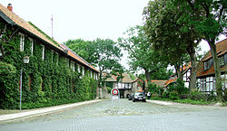
Wabe-Schunter-Beberbach
Wabe-Schunter-Beberbach | |
|---|---|
 Riddagshausen | |
| Coordinates: 52°16′50″N 10°33′37″E / 52.28056°N 10.56028°E | |
| Country | Germany |
| State | Lower Saxony |
| District | urban district |
| City | Braunschweig |
| Government | |
| • Mayor | Gerhard Stülten (SPD) |
| Area | |
• Total | 30.568 km2 (11.802 sq mi) |
| Population (2020-12-31)[1] | |
• Total | 20,204 |
| • Density | 660/km2 (1,700/sq mi) |
| Time zone | UTC+01:00 (CET) |
| • Summer (DST) | UTC+02:00 (CEST) |
| Postal codes | 38104-38110 |
| Dialling codes | 0531 |
| Vehicle registration | BS |
Wabe-Schunter-Beberbach is a Stadtbezirk (borough) in the north-eastern and eastern part of Braunschweig, Germany. The district is named after the river Schunter and its tributaries Wabe and Beberbach.
The Stadtbezirk comprises the quarters Bevenrode, Bienrode, Gliesmarode, Riddagshausen, Querum, and Waggum.
History
[edit]The district was formed in 2011 out of the former districts of Wabe-Schunter and Bienrode-Waggum-Bevenrode.[2][3] Both districts consisted of villages that were incorporated into Braunschweig during the 20th century, in 1934 (Gliesmarode, Querum, and Riddagshausen) and in 1974 (Bevenrode, Bienrode, and Waggum).
Main sights
[edit]- Riddagshausen Abbey (German: Kloster Riddagshausen), a former Cistercian monastery, with the surrounding nature reserve and arboretum, as well as the village of Riddagshausen with several old farm houses.[4] The nature reserve Riddagshäuser Teiche is designated as Important Bird Area[5] and Special Protection Area.[6]
- The inn Grüner Jäger ("Green Huntsman") in Riddagshausen, built in the mid-18th century.
- The 12th century Church of the Holy Trinity (German: Zur Heiligen Dreifaltigkeit) in Bienrode.[7]
- The 12th century Church St. Peter and Paul in Bevenrode.
- The Gliesmaroder Turm, formerly a tower in the medieval fortifications of Braunschweig which was torn down in the 18th century and replaced with an inn of the same name which still stands.[8]
-
Riddagshausen Abbey
-
Riddagshausen nature reserve
-
Farm house in Riddagshausen
-
Grüner Jäger
-
Church of the Holy Trinity
-
Bevenrode with St. Peter and Paul
-
Gliesmaroder Turm in the 19th century
-
Gliesmaroder Turm in 2011
Politics
[edit]The district mayor Gerhard Stülten is a member of the Social Democratic Party of Germany.[9]
Transport
[edit]Train
[edit]Braunschweig-Gliesmarode station is located on the Brunswick–Uelzen railway line, which connects the district with Braunschweig Central Station and several towns in the Lüneburg Heath.
| Line | Route | Frequency | |
|---|---|---|---|
| RB | Braunschweig – Gifhorn – Wittingen – Uelzen | Every two hours | |
Air
[edit]The Braunschweig Airport (BWE / EDVE) is located near Waggum at 52°19′N 10°33′E / 52.317°N 10.550°E, elev. 295 ft (90 m)
Coats of arms
[edit]-
Coat of arms of Bevenrode
-
Coat of arms of Bienrode
-
Coat of arms of Gliesmarode
-
Coat of arms of Querum
-
Coat of arms of Riddagshausen
-
Coat of arms of Waggum
References
[edit]- ^ "Einwohnerzahlen nach Stadtbezirken". Stadt Braunschweig. Retrieved 21 September 2021.
- ^ Boroughs of Braunschweig in 2010 (in German). Retrieved on October 4, 2012.
- ^ Boroughs of Braunschweig in 2011 (in German). Retrieved on October 4, 2012.
- ^ Die Geschichte des Ortes Riddagshausen (in German). Retrieved on October 4, 2012.
- ^ BirdLife Data Zone. Retrieved on November 4, 2012.
- ^ EUNIS Site factsheet. Retrieved on November 4, 2012.
- ^ History of the church (in German). Retrieved on October 4, 2012.
- ^ Gliesmaroder Turm (in German). Retrieved on October 4, 2012.
- ^ Stadtbezirksrat 112 Wabe-Schunter-Beberbach (in German). Retrieved on October 4, 2012.


