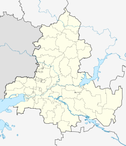
Vesyoly, Vesyolovsky District, Rostov Oblast
Vesyoly
Весёлый | |
|---|---|
| Coordinates: 47°05′05″N 40°44′15″E / 47.08472°N 40.73750°E | |
| Country | Russia |
| Federal subject | Rostov Oblast[1] |
| Administrative district | Vesyolovsky District[1] |
| Founded | 1845 |
| Population | |
• Total | 9,175 |
| Time zone | UTC+3 (MSK |
| Postal code(s)[3] | 347780-347781 |
| OKTMO ID | 60609411101 |
Vesyoly (Russian: Весёлый) is a rural locality (a posyolok) in Vesyolovsky District of Rostov Oblast, Russia, located 100 kilometers (62 mi) (or 79 kilometers (49 mi) in a straight line) from Rostov-on-Don. Population: 9,175 (2010 Census);[1] 8,820 (2002 Census).[4]. It is also the administrative center of Vesyolovsky District.
Geography
[edit]The settlement is situated on the left bank of Manych River in south-eastern part of Rostov Oblast.
History
[edit]Vesyoly khutor was founded in 1845 by Cossacks from the village of Bagaevskaya.
In this year, at the command of Ataman of Bagaevskaya, seven Cossacks were evicted with their families for rebelliousness, and this decision was approved by The Cossack Circle. The settlers were allocated a money share and began to build dugouts. From those seven dugouts, the history of khutor Vesyoly (originally known as Vesyolaya Semiizbyanka or Merry Seven Dugouts) began.
According to 1915 data, the khutor at that time had 300 households and a population of 1998 residents.[5]
During Russian Civil War the area around khutor was a place of fierce fightings. By Spring of 1920, it was taken by forces of Red Army.
In 1935 Vesyolovsky District of Rostov Oblast was established and Vesyoly became its administrative center.
During World War II Vesyoly was occupied by German forces from June 1942 to January 1943.[6]
References
[edit]- ^ a b c d e f Russian Federal State Statistics Service (2011). Всероссийская перепись населения 2010 года. Том 1 [2010 All-Russian Population Census, vol. 1]. Всероссийская перепись населения 2010 года [2010 All-Russia Population Census] (in Russian). Federal State Statistics Service.
- ^ "Об исчислении времени". Официальный интернет-портал правовой информации (in Russian). 3 June 2011. Retrieved 19 January 2019.
- ^ Почта России. Информационно-вычислительный центр ОАСУ РПО. (Russian Post). Поиск объектов почтовой связи (Postal Objects Search) (in Russian)
- ^ Federal State Statistics Service (21 May 2004). Численность населения России, субъектов Российской Федерации в составе федеральных округов, районов, городских поселений, сельских населённых пунктов – районных центров и сельских населённых пунктов с населением 3 тысячи и более человек [Population of Russia, Its Federal Districts, Federal Subjects, Districts, Urban Localities, Rural Localities—Administrative Centers, and Rural Localities with Population of Over 3,000] (XLS). Всероссийская перепись населения 2002 года [All-Russia Population Census of 2002] (in Russian).
- ^ "Донская электронная библиотека".
- ^ "Межпоселенческая центральная библиотека". bib-vesl.rnd.muzkult.ru. Retrieved 2017-03-10.


