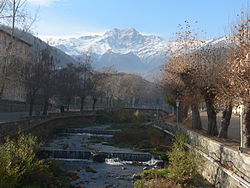
Vachagan
Appearance
This article needs additional citations for verification. (January 2021) |
| Vachagan | |
|---|---|
 The Vachagan in Kapan | |
 | |
| Location | |
| Country | Armenia |
| Physical characteristics | |
| Source | |
| • location | Mount Khustup, Syunik Mountains |
| • elevation | 1,050 m (3,440 ft) |
| Mouth | Voghji |
• location | Kapan |
• coordinates | 39°12′00″N 46°24′23″E / 39.2001°N 46.4063°E |
| Length | 11 km (6.8 mi) |
| Basin size | 35.7 km2 (13.8 sq mi) |
| Basin features | |
| Progression | Voghji→ Aras→ Kura→ Caspian Sea |
The Vachagan (Armenian: Վաչագան) is a river in the southern Syunik Province of Armenia.
Geography
[edit]
The Vachagan is a tributary of the Voghji running through a portion of southern Syunik Province, Armenia. It has a total length of 11.6 kilometres (7.2 mi) and a catchment area of 35.7 square kilometres (13.8 sq mi).[1]
