Ich kenne mancher Leute, die unter den Brüder des Dalai Lamas an die Indiana Universiät promoviert haben, die mir gesagt hat, dass die Familie des Dalai Lamas Mongour sei, und dass die ganze Familie fliessend Mongour kann. Sicher ist die Gegend, woher er kommt ein Bezirk wo viele Mongours wohnen. Das er Mongour ist, heisst natürlich nicht, dass er auch Tibetisch nicht sein kann. Mir sieht er sowieso eher Mongourisch aus. Tibetologist13:44, 1 January 2007 (UTC)[reply]
Relatives of the Dalai Lama in his hometown told me they are Tibetans. Although there are Monguor in the region, it is not the main area of the Monguor.
Thanks for uploading Image:Image-YushuGon.jpg. Wikipedia gets thousands of images uploaded every day, and in order to verify that the images can be legally used on Wikipedia, the source and copyright status must be indicated. Images need to have an image tag applied to the image description page indicating the copyright status of the image. This uniform and easy-to-understand method of indicating the license status allows potential re-users of the images to know what they are allowed to do with the images.
For more information on using images, see the following pages:
This is an automated notice by OrphanBot. If you need help on selecting a tag to use, or in adding the tag to the image description, feel free to post a message at Wikipedia:Media copyright questions. 12:06, 5 March 2007 (UTC)
Nangqên Domka Nedo Gompa There is another Nedo Gompa to the south of Nangqên county seat, in Peltsa community. The one named sdom kha'i gnas mdo khra 'od bde chen gling, however, is on the northern border of Nangqên county. Actually, this old monastery of the Nangchen kingdom is located near the border of Nangqên and Yushu counties, rather within Yushu than Nangqên county. Alos according to my sources, it was founded by Karm Chagme.
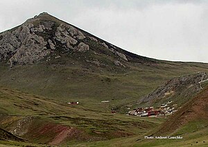
I was there once for a very short visit. It was in summer 2005 with many monks being on holiday staying with their families. At the time, they were busily preparing to relocate the monastery to a site near a major road, building new halls in concrete, of course. It was not clear, however, whether they would completely abandon the old site which is beautifully located in the mountain (see picture).
Dear Victor: the Wikimapia link you added has nothing to do with the Nedo monasteries. The satellite image shows two monasteries in Qinghai's Golog (Ngolok) Prefecture, the right one with the three chörten (typical representations of the Jonang style of chorten) being the [Jonangpa monastery Achonggya Gompa (the chörten are depicted on the front cover of my Amdo vol. 1 book (see picture). The monastery more to the left is the Nyingmapa monastery Cagri Gompa, quite a special architecture representing Padmasambhava's Copper Paradise (Sangdog Pelri). I wrote an article a few year's ago: «Symbolic Architecture in Pema - the Lotus Land of the Ngolok Nomads», in: Oriental Art, vol. XLVI No. 1 (Jan./ Feb. 2000), pp. 58-72. (main parts also in the above mentioned book). I added some information on the Wikimapia image.
--Gruschke (talk) 14:22, 2 August 2008 (UTC)[reply]
A number of competing categories were used so far to distinguish Tibetan Buddhist monasteries (or lamaseries) ending in that not all respective monasteries show up in either list, like:
Category:Buddhist monasteries in Tibet
Category:Buddhist_temples_in_Tibet
Category:Tibetan_Buddhist_monasteries
Category:Buddhist temples in China
I believe these should be somehow unitized/ unified in that monasteries which show up in Category 1 (Buddhist monasteries in Tibet) should at least also be listed in Category 3 (Tibetan_Buddhist_monasteries) - like the example of Benchen_Monastery which can be listed in all four categories. At the same time Xilituzhao Temple is listed in Category 2, although it is a temple in Inner Mongolia and not in Tibet. I am sure there are many more examples.
Hi, I have attempted to merge your article about that mountain range with Bayan Har Mountains. However, I left some information out because I myself have no real idea of the geography of Tibet. I you feel something is missing, please add it. Yaan (talk) 09:39, 24 November 2009 (UTC)[reply]
Thanks for removing the link to my article which presents results from several years of fieldwork on the topic discussed in the Wikipedia article... I added the link since it relates to the price development mentioned in the text, even shown by a diagram. Unjustifiably I thought that some people who have more time than me would go to read and decide what extra information could be taken from my article. You obviously read it and decided it to be not useful, and, as I understand you, why should this be interesting for other readers if the link was added by me, the author of the article himself? then it definitely must be spam or, at least, self-promotion. I better stay away from such forums and continue doing the actual research. Thanks for saving my time. --Gruschke (talk) 08:48, 9 August 2011 (UTC)[reply]
You haven't made any edits on English Wikipedia since 2013, but I hope you will return to your work one day. There is still a lot to do. Also, I wanted to let you know that the Pinyin for 互助土族自治县 should be Hùzhù Tǔzú Zìzhìxiàn and should not be written as Hùzhù Tǔzú zìzhìxiàn as you wrote in your edit from 2008 [1]. This is according to 汉语拼音正词法基本规则(2012) 6.2.2.1 which reads “汉语地名中的专名和通名,分写,每一分写部分的首字母大写。 “

