
User:Wolfy13399/Quebec and Lake St. John Railway
 | |
| Overview | |
|---|---|
| Headquarters | Quebec City |
| Key people | Sir Henri Gustave Joly |
| Reporting mark | QLSJR |
| Dates of operation | 1869–1918 |
| Successor | Canadian National |
The Quebec and Lake St-John Railway is a railway in Canada which connects Quebec City to Roberval on Lac Saint-Jean. The Quebec and Lac St-Jean Railway was the first to be built on the north shore of the St. Lawrence River, in 1869. The railway, 229 km long[1], reached Roberval in 1888 to allow the colonization of the region; which encouraged the creation of numerous hunting and fishing clubs all along the route dotted with lakes in an entirely forested region. In 1918, the railway was integrated into the Canadian National Railway.
Quebec and Gosford Railway
[edit]

In 1869, the Quebec and Gosford Railway (QGR) company, whose president was Henri-Gustave Joly, built a 41-km[2] wooden haul road linking Saint-Malo (near Rue Taillon)[3], a suburb of Quebec City, to Lac à l'Isle[4], in Gosford Township (Portneuf County), via Loretteville (the lake is located north of Saint-Joseph Lake, at the end of today's Gosford Road and Lumber Road). Construction cost $140000, of which $48171 was assumed by the Quebec provincial government. The main purpose of the road was to supply Quebec City with firewood and hemlock bark, a source of tannin for the leather industry.
The maple rails measure 14' long by 7" high by 4" wide (4.27 m x 177.8 mm x 101.6 mm); they are fastened by two end-to-end wedges in notches cut in large 12' long sleepers spaced 15" apart (3.66 m/ 381 mm); the distance between rails is 4 ft. 8½ in. (1435 mm)[5]. At Shannon, the Jacques-Cartier River is 61 m wide, and the QGR has to build a 19.1-ton capacity wooden bridge, 22 m high and extended by a trestle structure spanning 381 m[6] on the north side of the river (the wooden bridge was located some 40 m east of the present 1879 bridge[7], in order to use a rocky islet to build a central pillar). The bridge was inaugurated on November 26, 1870. On December 24, 1870, the name of the QGR was changed to the Quebec and Lake St-John Railway (QLSJR)[8]. At Loretteville, the grade is 47 m per km. But the wooden track could not withstand rain or winter, the price of firewood was uncompetitive and the line did not provide access to the downtown port of Quebec. The company ceased operations in 1874.
Quebec and Lake St-John Railway (QLSJR)
[edit]In 1874, the QLSJR was reorganized by a group of businessmen including James Guthrie Scott and Horace Jansen Beemer, an American entrepreneur involved in numerous rail projects in Canada; in 1875, the group obtained government authorization to extend the line to Lake St-John[9].
The route is studied at length by the Quebec government. In the winter of 1870, surveyor Eugène Casgrain located a route to extend the Quebec-Gosford line from the Jacques-Cartier River to the Ste-Anne River (St-Raymond), to join the Metabetchouan River valley north of the Laurentian mountain range, leading to Lac St-Jean; in 1873, surveyor John Sullivan confirmed the route. Relying on people familiar with the Laurentians, the Honorable J. C. Langelier suggested exploring a more westerly route, along the Batiscan River, with less elevation and crossing fertile lands including those of St-Raymond and Lac Édouard, as well as forests with timber suitable for export. In 1874, a report by surveyor P. H. Dumais confirmed Langelier's information and proposed the route that would be adopted, albeit 20 miles longer, via St-Raymond, Rivière-à-Pierre, the Batiscan River, Lake Édouard and the Ouiatchouan River. The report already mentions the possibility of easily joining the St-Maurice River at La Tuque via the La Jeannotte River[10].
The QGR route from Saint-Malo to Loretteville was replaced by that from Hedleyville (Vieux-Limoilou) to Loretteville via the gentler slope throughCharlesbourg to serve this important village. In 1879, the Shannon railway bridge was rebuilt west of the 1869 wooden bridge (in line with today's Gosford Road, thus smoothing out the 3 curves visible on the original plan above), and the QGR route, north of the Jacques-Cartier River, was diverted westwards: Duchesnay (south of Saint-Joseph Lake), Lac Sergent, Bourg-Louis and Saint-Raymond. Construction of the railroad began in 1880.
-
 Route via the North Shore Railway 1883-07-10
 -
 Jacques-Cartier River Bridge of 1879
 -
 Steam shovel loading earth onto a tilting wagon.
 -
 Palais railway station circa 1876
 -
 Original workshop in St-Malo (Quebec)
 -
 Hotel Roberval circa 1895
 -
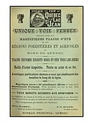 1890 publicity
 -
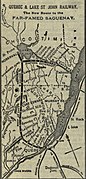 Map from 1901
 -
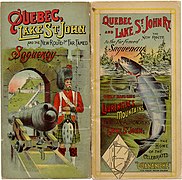 1906 Leaflet


_vers_1895.jpg)

.jpg)

To speed up commissioning, while avoiding the need to cross the St. Charles twice, the old QGR route (10.5 miles/17 km) west of the St. Charles River valley was temporarily used, along with the first Gare du Palais[11] near the port of Quebec: departure from the Palais station was via the new Quebec, Montreal, Ottawa and Occidental Railway to the QGR "junction" 4 miles to the west. From the junction, the track runs northwest to White-house (Loretteville; this route roughly follows rue l'Ormière-Masson), then heads for Shannon along the route of today's autoroute Henri IV. Around the same period, the QLSJR built a repair shop in Saint-Malo near the QMO&OR track, which was sold to the Canadian Pacific Railway (CPR) in 1885, which charged a very high user fee for the 4-mile (6.44 km) section.
The railroad reached Saint-Raymond on 1 June 1881 (58 km)[12]. In July 1883, the Quebec and Lake St John Lumbering and Trading Company commissioned contractor Horace Jansen Beemer to build the final 217 km[13]. The line reached Lac Édouard in 1886 and Roberval at Lac Saint-Jean in 1888[14]. A station with telegraph, a dormitory, a marshalling yard, a water tower, a coal chute and a steam locomotive repair shop were built near Lake Édouard, 179 km from Quebec City, halfway to Lac St-Jean; the six service bays of the semicircular shop (the "rotunda") could accommodate locomotives thanks to the rails fanned out opposite a swing bridge. The workshop closed in the 1950s with the arrival of diesel locomotives. It was Beemer who built the Hôtel Roberval in 1888 (enlarged in 1891 and destroyed by fire in 1908).
Forty-five percent of the $8.7 million construction cost was borne by the federal, provincial and municipal governments. The QLSJR promoted tourism among its affluent clientele, and for many years, the title page of its timetable flyer depicted its rail line framed by the silhouette of a landlocked salmon (freshwater salmon from Lac Saint-Jean; 1906 flyer above). The 1894 brochure mentions that the QLSJR leased fishing rights on Lake Édouard from the Quebec government for the benefit of railroad users, and provided all required services (boats, guides, etc.) through the manager of the Laurentides House hotel located near the station.
-
 Railway swing bridge over the St-Charles River.
 -

-
 QLSJR workshop and station built in 1891 near the port of Quebec.
 -
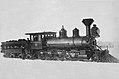 Locomotive named after the Honorable François Langelier.

.jpg)


In 1890[15], the QLSJR finally received the promised government subsidies and built the track section (12 miles/19.35 km) between Loretteville, Charlesbourg and Limoilou, as well as a swing bridge over the Saint-Charles River in Quebec City to connect directly with the first Palais station[16]). The swing bridge[17] will take on the popular name of Pont Sainte-Anne (the Quebec Montmorency & Charlevoix Railway[18], QMCR, built in 1889, links the Hedleyville station[19] to Sainte-Anne-de-Beaupré, famous for its basilica and pilgrimages; the station is located just north of the Saint-Charles River, where the QLSJR tracks meet to the north and the QMCR to the east).
In 1891, the QLSJR built a three-story masonry station on rue Saint-André in the Port of Québec, along with a workshop, marshalling yard and roundhouse. The route via St. Malo is permanently replaced by the new route via Hedleyville and Charlesbourg (its St. Malo properties are transferred to the National Transcontinental Railway). In 1894, the QMCR also built a station on nearby Saint-Paul Street[20]. In 1892, a subdivision was built between Chambor and Chicoutimi (75 miles/121 km[1]). In 1895, the QLSJR acquired the section of the Lower Laurentian Railway (Basses Laurentides), built in 1887 between the Les Piles line (linked to Trois-Rivières on the Canadian Pacific Railway, formerly the QMO&O) and Ste-Thècle; it became part of the Great Northern Railway of Canada in 1900[21]. The Rivière-à-Pierre to Grand-Mère subdivision appears on the route of the 1898 brochure[22], whereas the previous destination was La Tuque (a subdivision not built until 1907, starting at Linton). In 1901, the QLSJR built a new 63.6-ton bridge at Shannon, 1km west of the 1879 bridge, to eliminate the long detour (a bridge that still exists in 2019).
Canadian Northern Railway (CNoR)
[edit]Canadian National Railways (CNR)
[edit]See also
[edit]| Former component railways |
| ||||||||||||||
|---|---|---|---|---|---|---|---|---|---|---|---|---|---|---|---|
| Former subsidiaries | |||||||||||||||
| Joint Partnerships | |||||||||||||||
| Under long-term lease | |||||||||||||||
| Other | |||||||||||||||
[[Category:Predecessors of the Canadian National Railway]] [[Category:Defunct railway companies of Canada]] [[Category:Defunct Quebec railways]] [[Category:Rail transport in Quebec]] [[Category:Railway companies disestablished in 1918]] [[Category:Railway companies established in 1869]]
- ^ a b Reports, Railway Statistics of Canada and Capital, Traffic and Working Expenditure of the Railways of the Dominion. 1889. p. 12.
- ^ Trout, John Malcom (1871). "Quebec and Gosford Railway". The Railways of Canada for 1870-1. Toronto. pp. 161–162.
{{cite book}}: CS1 maint: location missing publisher (link) - ^ "Wooden Railway Was Forerunner Of Quebec Rail Communications". Quebec Chronicle-Telegraph. 1955-03-28.
- ^ Prospectus of the Quebec and Lake St. John Railway (formerly Quebec and Gosford Railway). Quebec: Morning Chronicle office. 1875. pp. 8–9.
- ^ "Local Railway Items from Ottawa Papers - Gosford Pole Railway. A wooden railway (a letter from Quebec)" (PDF). Ottawa Citizen. 1871-11-25.
- ^ "Les ponts de bois en milieu forestier au Québec" (PDF). shfq.ca (in French). Archived from the original (pdf) on 2016-08-26.
- ^ "Clark's Steel Bridge 1892". pbalkcom.com. Archived from the original on 2016-07-11.
- ^ Quebec Act 34 Victoria, chapter. 24, December 24, 1870
- ^ Quebec Act 38 Victoria, Chapter 46, 1875
- ^ Gagnon, Rodolphe (1967-12-04). LE CHEMIN DE FER DE QUÉBEC AU LAC SAINT-JEAN (1854-1900) (pdf) (in French). Laval University.
- ^ "Rue du Palais; fiche no 1064; ville de Québec; patrimoine; toponymes". www.ville.quebec.qc.ca. Retrieved 2024-07-04.
- ^ Poor, Henry Varnum (1885). Poor's Manual of Railroads. Vol. 18. H.V. & H.W. Poor. p. 932.
- ^ Dictionnaire biographique du Canada. Vol. XIV (1911-1920).
- ^ Buis, Arthur (1895). Le chemin de fer du lac St-Jean (PDF) (in French).
- ^ Report of the Royal Commission in Reference to Certain Charges Made Against Hon. Sir A.P. Caron. S.E. Dawson, printer. 1893. p. 353.
- ^ "The Quebec Daily Telegraph - Google News Archive Search". news.google.com. Retrieved 2024-07-04.
- ^ The, Quebec Railway, Light & Power Co, ed. (1927). Quebec, Montmorency falls and Ste-Anne de Beaupré (PDF). p. 30.
{{cite book}}: CS1 maint: multiple names: editors list (link) - ^ Lebel, Jean-Marie (1996). Les Éditions Cap-aux-Diamants inc. (ed.). "La rivière St-Charles au cours des temps" (PDF). Cap-Aux-Diamants (in French): 26. ISSN 1923-0923.
- ^ "Gartcraig brick found in Québec City, Canada | Scotland's Brick and Tile Manufacturing Industry". www.scottishbrickhistory.co.uk. 2015-06-13. Retrieved 2024-07-04.
- ^ Lachance, Matthieu (2010-12-04). "Hedley Junction: Prototype History". Hedley Junction. Retrieved 2024-07-04.
- ^ Verrette, René (1998). "Entre le rêve et la réalité : l'implantation du réseau ferroviaire mauricien" (PDF). Cap-aux-Diamants (in French) (54). ISSN 0829-7983.
- ^ "The New Route To The Far-Famed Saguenay" (JPG). Library and Archives Canada.