User:Vidioman/Sandbox
| This is a workpage—an article being developed. When complete, it will go here. |
Government
[edit]
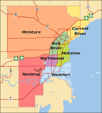
Thunder Bay is a single-tier municipality governed by a council-manager system. The Thunder Bay City Council is a unicameral legislative body comprising a mayor and twelve councillors. The mayor and five "councillors-at-large" are elected by the entire voting population of the city, while the seven remaining councillors are elected in wards. The mayor and members of the city council serve four-year terms without term limits. (Prior to the 2006 municipal election, the mayor and city councillors served three-year terms.) The seven wards are Current River, McIntyre, McKeller, Neebing, Northwood, Red River, and Westfort.[1] Thunder Bay's city manager is Tim Comisso.[2] As the city's senior administrative official, the city manager is responsible for the overall administration of city departments and developing policies, and provides advice to city councillors on city organization and operating procedure.[3]
Thunder Bay is represented in the Canadian Parliament by New Democratic Party members Bruce Hyer and John Rafferty, and in the Ontario Legislature by Ontario Liberal Party members Michael Gravelle and Bill Mauro.
City symbols
[edit]There are various symbols associated with the City of Thunder Bay.
- Sleeping Giant
The Sleeping Giant is a formation of mesas and sills on the Sibley Peninsula in Lake Superior which resembles a reclining giant is a well known symbol of the city. The Sibley Peninsula partially encloses the waters of Thunder Bay, and dominates the view of the lake from the northern section of the city. The Sleeping Giant also figures on the city's coat of arms and the city flag. It received the most votes in the online survey for the Seven Wonders of Canada competition sponsored by the CBC. It did not make it to the final list of seven but was designated as the "People's Choice" wonder.[4]
- Coat of arms
thumb|right|The Coat of Arms of the City of Thunder Bay, which incorporates features from the coats of arms of Port Arthur and Fort William. The Coat of arms of Thunder Bay, Ontario is a combination of the coats of arms of both Port Arthur and Fort William, with a unifying symbol—the Sleeping Giant—at the base of the arms.[5]
- Corporate logo
The city logo depicts a stylized thunderbird, called Animikii, a statue of which is located on the city's Kaministiquia River Waterfront Park. The slogan, Superior by Nature, is a double play on words reflecting the city's natural setting on Lake Superior.[6]
- City flag
Thunder Bay's flag was created in 1972, when mayor Saul Laskin wanted to promote the city by having a distinctive flag. The city held a contest, which was won by Cliff Redden. The flag has a 1:2 ratio, and depicts a golden sky from the rising sun behind the Sleeping Giant, which sits in the blue waters of Lake Superior. The sun is represented by a red maple leaf, a symbol of Canada. Green and gold are Thunder Bay's city colours.[7]
Sister cities
[edit]Thunder Bay has five sister cities on three continents, which are selected based on economic, cultural and political criteria.[8]
 Seinäjoki, Finland since 1974
 Little Canada, Minnesota since 1977
 Duluth, Minnesota since 1980
 Keelung, Taiwan since 1988
 Gifu, Japan since 2006
Geography
[edit]

The city has an area of 328.48 square kilometres which includes the former cities of Fort William and Port Arthur as well as the townships of Neebing, Ontario and McIntyre.
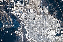
The former Fort William section occupies flat alluvial land along the Kaministiquia River which has a river delta at its mouth of two large islands known as Mission Island and McKellar Island. The former Port Arthur section is more typical of the Canadian Shield, with gently sloping hills and very thin soil lying on top of bedrock with many bare outcrops. Thunder Bay, which gives the city its name, is immense—about 22.5 kilometres (14 miles) from the Port Arthur downtown to Thunder Cape at the tip of the Sleeping Giant.
The city reflects the settlement patterns of the 19th century. It is therefore highly spread out for historical reasons. Anchoring the west end of the city, the Fort William Town Plot surveyed in 1859–60 was named West Fort William (Westfort) in 1888 by the CPR. The land adjoining the lower Kaministiquia River became the residential and central business district of the town and city of Fort William. A large uninhabited area adjoining the Neebing and McIntyre rivers which became known as Intercity separated Fort William from the residential and central business district of Port Arthur. At the extreme east of the city, a part of McIntyre Township was annexed to the town of Port Arthur in 1892, forming what later became known as the Current River area.
Since 1970, the central business districts of Fort William and Port Arthur have suffered a serious decline as business and government have relocated to the Intercity area. There has also been substantial residential growth in adjacent areas of the former Neebing and McIntyre townships.
Climate
[edit]The climate of Thunder Bay and area is influenced by Lake Superior, which is especially noticeable in the city's north end, resulting in cooler summer temperatures and warmer winter temperatures for an area extending inland as far as 16 km. The average daily temperatures range from a high of 17.6 °C in July and a low of -14.8 °C in January. The average daily high in July is 24.2 °C and the average daily high in January is -8.6 °C. On January 10, 1982, the local temperature in Thunder Bay dropped to -36 °C, with a wind speed of 54 km/h for a wind chill temperature that dipped to -58 °C. As a result, it holds Ontario's record for coldest day with wind chill.[9] The city is quite sunny with an average of 2167.7 hours of bright sunshine each year, ranging from 283.4 hours in July to 88.8 hours in November, sunnier than any city in Canada located to the east of it.[10]
| Thunder Bay Climatological Data | ||||||||||||||
|---|---|---|---|---|---|---|---|---|---|---|---|---|---|---|
| Temperature | ||||||||||||||
| Month | Jan | Feb | Mar | Apr | May | Jun | Jul | Aug | Sep | Oct | Nov | Dec | Total | |
| Record high °C (°F) | 8 (47) | 12 (54) | 23 (73) | 28 (83) | 35 (95) | 36 (96) | 37 (99) | 40 (105) | 32 (89) | 28 (83) | 22 (71) | 12 (54) | ||
| Average high °C (°F) | -9 (17) | -6 (22) | 0.3 (33) | 9 (48) | 16 (62) | 21 (69) | 24 (76) | 23 (74) | 17 (63) | 10 (51) | 2 (35) | -6 (21) | 9 (48) | |
| Mean °C (°F) | -15 (5) | -12 (10) | -6 (21) | 3 (37) | 10 (49) | 14 (57) | 18 (64) | 17 (62) | 11 (52) | 5 (41) | -3 (27) | -12 (11) | 3 (37) | |
| Average low °C (°F) | -21 (-6) | -18 (-1) | -11 (12) | -3 (26) | 3 (37) | 7 (45) | 11 (52) | 10 (50) | 5 (41) | -0.5 (31) | -8 (18) | -17 (1) | -4 (26) | |
| Record low °C (°F) | -41 (-42) | -40 (-40) | -38 (-36) | -22 (-8) | -9 (16) | -3 (27) | 0 (32) | -1 (30) | -8 (17) | -13 (8) | -31 (-23) | -38 (-36) | ||
| Precipitation and Sunshine Hours | ||||||||||||||
| Month | Jan | Feb | Mar | Apr | May | Jun | Jul | Aug | Sep | Oct | Nov | Dec | Total | |
| Total mm (in) | 31 (1.2) | 25 (1.0) | 42 (1.6) | 42 (1.6) | 67 (2.6) | 86 (3.4) | 89 (3.5) | 88 (3.4) | 88 (3.5) | 63 (2.5) | 56 (2.2) | 38 (1.5) | 712 (28) | |
| Rainfall mm (in) | 3 (0.1) | 3 (0.1) | 18 (0.7) | 30 (1.2) | 65 (2.6) | 86 (3.4) | 89 (3.5) | 86 (3.4) | 86 (3.4) | 57 (2.2) | 33 (1.2) | 4 (0.1) | 559 (22) | |
| Snowfall cm (in) | 41 (16.2) | 27 (10.6) | 27 (10.6) | 12 (4.9) | 2 (0.7) | 0 (0) | 0 (0) | 0 (0) | 0.5 (0.2) | 6 (2.4) | 28 (11.0) | 44 (17.4) | 187.6 (74) | |
| Sunshine hours | 114 | 134 | 159 | 219 | 265 | 264 | 283 | 258 | 163 | 128 | 89 | 92 | 2168 | |
| Data recorded at Thunder Bay International Airport by Environment Canada. Data spans 1971 to 2000. | ||||||||||||||
- ^ Ward Map, City Government, Your Council. Retrieved on March 13, 2009
- ^ Burkowski, Peter. "City appoints new city manager," The Chronicle-Journal (August 19, 2008). Retrieved August 19, 2008.
- ^ City Manager's Office. Retrieved March 13, 2009.
- ^ "Results of the Seven Wonders of Canada", CBC.ca. Retrieved March 13, 2009.
- ^ Logos and Symbols - Coat of Arms. Retrieved on March 13, 2009.
- ^ Logos and Symbols - Logo. Retrieved on March 13, 2009.
- ^ Logos and Symbols - Flag. Retrieved on March 13, 2009.
- ^ Thunder Bay Sister Cities. Retrieved on March 13, 2009
- ^ Ontario Region Winter Weather Factsheet, Environment Canada. Retrieved on 11 April 2008
- ^ Canadian Climate Normals, Thunder Bay A, Ontario. Environment Canada. Retrieved on 4 June 2007
Neighbourhoods
[edit]Thunder Bay is composed of two formerly separate cities, Port Arthur and Fort William, and both still retain a large amount of their civic identity, reinforced by the buffering effect the Intercity area has between them. Both Port Arthur and Fort William have their own central business districts and suburban areas. Some of the more well-known neighbourhoods include: the Bay and Algoma area, which has a large northern European population centred around the Finnish Labour Temple and the Italian Cultural Centre; Simpson-Ogden and the East End, two of the oldest neighbourhoods in Fort William located north of Downtown Fort William; Intercity, a large business district located between Fort William and Port Arthur; Current River, the northernmost neighbourhood of Port Arthur, and Westfort, the oldest settlement in Thunder Bay. Within city limits are some small rural communities, such as Vickers Heights and North McIntyre, which were located in the former townships of Neebing and McIntyre respectively.
