User:Out of this World Adventure/Airports
Welcome to my Favorite Airports Page. Skip Contents Bar Back to Out of this World Adventure Subpages
Airports
[edit]Find Airports by code: JAX-ATL-MSP-SEA-STL
Jacksonville International Airport | |||||||||||||||
|---|---|---|---|---|---|---|---|---|---|---|---|---|---|---|---|
 | |||||||||||||||
| Summary | |||||||||||||||
| Airport type | Public | ||||||||||||||
| Owner/Operator | Jacksonville Aviation Authority | ||||||||||||||
| Serves | Jacksonville metropolitan area | ||||||||||||||
| Location | Jacksonville, Florida, U.S. | ||||||||||||||
| Elevation AMSL | 30 ft / 9 m | ||||||||||||||
| Coordinates | 30°29′39″N 081°41′16″W / 30.49417°N 81.68778°W | ||||||||||||||
| Website | http://www.flyjax.com | ||||||||||||||
| Maps | |||||||||||||||
 FAA airport diagram | |||||||||||||||
 | |||||||||||||||
| Runways | |||||||||||||||
| |||||||||||||||
| Statistics (2016) | |||||||||||||||
| |||||||||||||||
Jacksonville International Airport (IATA: JAX, ICAO: KJAX, FAA LID: JAX) is a civil-military public airport 13 miles (21 km) north of Downtown Jacksonville, in Duval County, Florida. It is owned and operated by the Jacksonville Aviation Authority.
The airport covers 7,911 acres (3,201 ha) and has two concrete runways: 8/26, 10,000 x 150 ft (3,048 x 46 m) and 14/32, 7,701 x 150 ft (2,347 x 46 m).[1] The terminal at JIA is composed of a baggage claim area, on the first floor and a ticketing area on the second floor, at the front of the structure. Past baggage claim and ticketing is the mezzanine, where shops, restaurants and the security checkpoint are located. Beyond the mezzanine are the airport's Concourses
A and C, which include 10 gates each (for a total of 20), along with other shops and restaurants.[2]
The airport also has a Delta Sky Club on Concourse A.
The airport's two runways form a "V" (with the tip of the "V" pointing west). A plan exists to build two more runways, each paralleling one existing runway. The one alongside the existing southern runway will be built first. No date has been set (the expectation is that construction of the third runway would begin around 2015).[citation needed]
In the fiscal year ending September 2016 the airport had 101,575 aircraft operations, an average of 278 per day: 58% scheduled commercial, 19% air taxi, 15% general aviation and 8% military. In August 2017, there were 54 aircraft based at this airport: 3 single-engine, 8 multi-engine, 25 jet and 18 military.[1]
User:Out of this World Adventure/Jacksonville International Airport
Hartsfield–Jackson Atlanta International Airport | |||||||||||||||||||||||||||
|---|---|---|---|---|---|---|---|---|---|---|---|---|---|---|---|---|---|---|---|---|---|---|---|---|---|---|---|
 | |||||||||||||||||||||||||||
| Summary | |||||||||||||||||||||||||||
| Airport type | Public | ||||||||||||||||||||||||||
| Owner | City of Atlanta | ||||||||||||||||||||||||||
| Operator | Atlanta Department of Aviation | ||||||||||||||||||||||||||
| Serves | Atlanta, Georgia, U.S. | ||||||||||||||||||||||||||
| Location | Unincorporated areas of Fulton and Clayton counties; also Atlanta, College Park, and Hapeville, Georgia | ||||||||||||||||||||||||||
| Hub for | |||||||||||||||||||||||||||
| Focus city for | |||||||||||||||||||||||||||
| Elevation AMSL | 1,026 ft / 313 m | ||||||||||||||||||||||||||
| Coordinates | 33°38′12″N 084°25′41″W / 33.63667°N 84.42806°W | ||||||||||||||||||||||||||
| Website | www.atl.com | ||||||||||||||||||||||||||
| Maps | |||||||||||||||||||||||||||
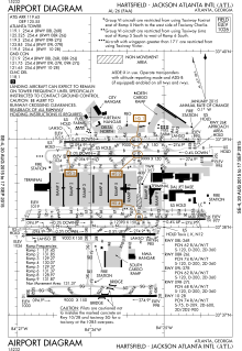
 FAA airport diagram | |||||||||||||||||||||||||||
Location of airport in Metro Atlanta | |||||||||||||||||||||||||||
 | |||||||||||||||||||||||||||
| Runways | |||||||||||||||||||||||||||
| |||||||||||||||||||||||||||
| Helipads | |||||||||||||||||||||||||||
| |||||||||||||||||||||||||||
| Statistics (2017) | |||||||||||||||||||||||||||
| |||||||||||||||||||||||||||
Hartsfield–Jackson Atlanta International Airport (IATA: ATL, ICAO: KATL, FAA LID: ATL), also known as Atlanta Airport, Hartsfield, or Hartsfield–Jackson, is an international airport located 7 miles (11 km) south of Atlanta's central business district, in the U.S. state of Georgia. It is named after former Atlanta mayors William B. Hartsfield and Maynard Jackson. The airport has 209 domestic and international gates.[3] ATL covers 4,700 acres (1,902 ha) of land and has five parallel runways.[3]
The airport has international service within North America and to countries in South America, Central America, Europe, Africa and Asia. As an international gateway to the United States, Hartsfield–Jackson ranks sixth.[4] Many of the nearly one million flights are domestic flights from within the United States, where the airport serves as a major hub for travel throughout the southeastern region of the country.
Atlanta has been the world's busiest airport by passenger traffic since 1998; and by number of landings and take-offs from 2005 to 2013, losing that title to Chicago–O'Hare in 2014, but regaining it a year later.[5][6] Hartsfield–Jackson held its ranking as the world's busiest airport in 2012, both in passengers and number of flights, by accommodating 100 million passengers (more than 260,000 passengers daily) and 950,119 flights.[4][7][8] In 2017, it remained the busiest airport in the world with 104 million passengers.[9]
Hartsfield–Jackson is the primary hub of Delta, and is a focus city for low-cost carriers Frontier, Southwest, and Spirit. With just over 1,000 flights a day, the Delta hub is the world's largest hub.[10][11] Delta Air Lines flew 75.4% of the airport's passengers in February 2016, Southwest flew 9.2%, and American Airlines flew 2.5%.[12] In addition to hosting Delta corporate headquarters, Hartsfield–Jackson is also the home of Delta's Technical Operations Center, which is the airline's primary maintenance, repair and overhaul arm.[13]
Minneapolis–Saint Paul International Airport Wold–Chamberlain Field | |||||||||||||||||||||||
|---|---|---|---|---|---|---|---|---|---|---|---|---|---|---|---|---|---|---|---|---|---|---|---|
 | |||||||||||||||||||||||
 | |||||||||||||||||||||||
| Summary | |||||||||||||||||||||||
| Airport type | Public | ||||||||||||||||||||||
| Owner/Operator | Metropolitan Airports Commission | ||||||||||||||||||||||
| Serves | Minneapolis and St. Paul, Minnesota (Twin Cities) | ||||||||||||||||||||||
| Location | Hennepin County, Minnesota, U.S. | ||||||||||||||||||||||
| Hub for | |||||||||||||||||||||||
| Elevation AMSL | 841 ft / 256 m | ||||||||||||||||||||||
| Coordinates | 44°52′55″N 093°13′18″W / 44.88194°N 93.22167°W | ||||||||||||||||||||||
| Website | www.mspairport.com | ||||||||||||||||||||||
| Maps | |||||||||||||||||||||||
 FAA airport diagram | |||||||||||||||||||||||
 | |||||||||||||||||||||||
| Runways | |||||||||||||||||||||||
| |||||||||||||||||||||||
| Statistics (2017) | |||||||||||||||||||||||
| |||||||||||||||||||||||
Minneapolis–Saint Paul International Airport (IATA: MSP, ICAO: KMSP, FAA LID: MSP), also less commonly known as Wold–Chamberlain Field, is a joint civil-military public use international airport. It is located in a portion of Hennepin County, Minnesota, United States, within 10 miles (16 kilometers) of both downtown Minneapolis and Saint Paul. MSP is the largest and busiest airport in the six-state Upper Midwest region of Minnesota, Iowa, Nebraska, North Dakota, South Dakota, and Wisconsin.[14] The airport is mostly located in the census-designated place of Fort Snelling in an unincorporated portion of Hennepin County.[15] Small sections of the airport are within the city limits of Minneapolis and Richfield. However, per Minnesota state law, the land on which the airport sits is not part of any city or school district.[16]
Seattle–Tacoma International Airport Sea–Tac Airport | |||||||||||||||||||
|---|---|---|---|---|---|---|---|---|---|---|---|---|---|---|---|---|---|---|---|
 | |||||||||||||||||||
 Sea–Tac Airport in May 2012, looking south | |||||||||||||||||||
| Summary | |||||||||||||||||||
| Airport type | Public | ||||||||||||||||||
| Owner/Operator | Port of Seattle | ||||||||||||||||||
| Serves | Seattle and Tacoma, Washington | ||||||||||||||||||
| Location | SeaTac, Washington, U.S. | ||||||||||||||||||
| Hub for | |||||||||||||||||||
| Elevation AMSL | 433 ft / 132 m | ||||||||||||||||||
| Coordinates | 47°26′56″N 122°18′34″W / 47.44889°N 122.30944°W | ||||||||||||||||||
| Website | portseattle.org/sea-tac | ||||||||||||||||||
| Maps | |||||||||||||||||||
 FAA diagram | |||||||||||||||||||
 | |||||||||||||||||||
| Runways | |||||||||||||||||||
| |||||||||||||||||||
| Statistics (2017) | |||||||||||||||||||
| |||||||||||||||||||
Seattle–Tacoma International Airport (IATA: SEA, ICAO: KSEA, FAA LID: SEA), also referred to as Sea–Tac Airport or Sea–Tac, is the primary commercial airport serving the Seattle metropolitan area in the U.S. state of Washington. It is located in the city of SeaTac, approximately 14 miles (23 km) south of Downtown Seattle and 18 miles (29 km) north-northeast of Downtown Tacoma.[17] The airport, the largest in the Pacific Northwest region of North America, is owned and operated by the Port of Seattle.
St. Louis Lambert International Airport | |||||||||||||||||||||||
|---|---|---|---|---|---|---|---|---|---|---|---|---|---|---|---|---|---|---|---|---|---|---|---|
 | |||||||||||||||||||||||
| Summary | |||||||||||||||||||||||
| Airport type | Government owned | ||||||||||||||||||||||
| Owner | City of St. Louis | ||||||||||||||||||||||
| Operator | St. Louis City Airport Commission | ||||||||||||||||||||||
| Serves | St. Louis, Missouri | ||||||||||||||||||||||
| Location | Unincorporated St. Louis County 10 miles (16 km) NW of St. Louis | ||||||||||||||||||||||
| Hub for | |||||||||||||||||||||||
| Focus city for | |||||||||||||||||||||||
| Elevation AMSL | 605 ft / 184.4 m | ||||||||||||||||||||||
| Coordinates | 38°44′50″N 090°21′41″W / 38.74722°N 90.36139°W | ||||||||||||||||||||||
| Website | http://www.flystl.com/ | ||||||||||||||||||||||
| Maps | |||||||||||||||||||||||
 FAA Airport Diagram | |||||||||||||||||||||||
 | |||||||||||||||||||||||
| Runways | |||||||||||||||||||||||
| |||||||||||||||||||||||
| Statistics (2017) | |||||||||||||||||||||||
| |||||||||||||||||||||||
St. Louis Lambert International Airport (IATA: STL, ICAO: KSTL, FAA LID: STL), formerly Lambert–St. Louis International Airport, is an international airport serving St. Louis, Missouri, United States. It is 14 miles (23 km) northwest of downtown St. Louis in unincorporated St. Louis County between Berkeley and Bridgeton. Commonly referred to as Lambert Field or simply Lambert, it is the largest and busiest airport in Missouri with over 270 daily departures[18] to over 80 domestic and international locations. In 2017, 14.7 million passengers traveled through the airport.[19] The airport is a focus city for Southwest Airlines and serves as a hub for Air Choice One and Cape Air, and was formerly a hub for Ozark Air Lines, Trans World Airlines, and American Airlines. It is the largest U.S. airport classified as a medium-sized primary hub and currently the second busiest after Dallas–Love.[20]
Out of this World Adventure 🌎 Subpages
Airport Notes
[edit]- ^ a b Cite error: The named reference
FAAwas invoked but never defined (see the help page). - ^ "Terminal Maps". Jacksonville International Airport. Retrieved June 13, 2014.
- ^ a b Cite error: The named reference
factswas invoked but never defined (see the help page). - ^ a b Cite error: The named reference
ATLstatswas invoked but never defined (see the help page). - ^ Tharpe, Jim (January 4, 2007). "Atlanta Airport Still the "Busiest"". The Atlanta Journal-Constitution. Archived from the original on January 6, 2007. Retrieved January 4, 2007.
- ^ "12 months". Aci.aero. Retrieved 2016-04-28.
- ^ "Year to date Aircraft Movements". Airports Council International. November 12, 2008. Archived from the original on January 1, 2009. Retrieved December 1, 2009.
- ^ Yamanouchi, Kelly (March 28, 2012). "Hartsfield–Jackson Remains No. 1 Airport". The Atlanta Journal-Constitution. Retrieved June 23, 2013.
- ^ "The world's busiest airport revealed". CNN Travel. 2018-09-20. Retrieved 2018-09-20.
- ^ "Hartsfield–Jackson Atlanta International Airport". Delta Air Lines. Retrieved June 23, 2013.
- ^ "Delta Hub Station". Retrieved 29 June 2016.
- ^ . 9 May 2016 https://web.archive.org/web/20160509004528/http://www.atlanta-airport.com/docs/Traffic/201602.pdf. Archived from the original (PDF) on 9 May 2016.
{{cite web}}: Missing or empty|title=(help) - ^ "Delta TechOps". CAPA Centre for Aviation. Retrieved June 12, 2013.
- ^ "List of Top 40 Airports in US - World Airport Codes". World Airport Codes.
- ^ "Fort Snelling UT, Hennepin County, Minnesota". U.S. Census Bureau. Retrieved December 19, 2009.[permanent dead link]
- ^ "2012 Minnesota Statutes". State of Minnesota. 2012. Retrieved June 24, 2013.
- ^ "Mileage Charts: Starting from SeaTac Airport". Washington State Department of Transportation. Retrieved December 5, 2018.
- ^ "Departure Statistics". Lambert–St. Louis International Airport. Retrieved February 5, 2018.
- ^ Cite error: The named reference
Passenger Statswas invoked but never defined (see the help page). - ^ https://www.faa.gov/airports/planning_capacity/passenger_allcargo_stats/passenger/media/preliminary-cy2017-commercial-service-enplanements.pdf


