
User:Newbiepedian/Lindenthal (Cologne district)
Lindenthal | |
|---|---|
District (Stadtteil) | |
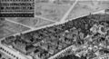
 Aerial photograph of Lindenthal | |
| Etymology: Compound of German Linde (linden tree) and Tal (valley) | |
 Location of Lindenthal district in the Borough of Lindenthal | |
| Coordinates: 50°55′34″N 6°54′36″E / 50.92611°N 6.91000°E | |
| Country | Germany |
| City | Cologne |
| Borough | Lindenthal |
| Founded | 1843 |
| Annexed | 1888 |
| Founded by | Herr Thelen & Herr Fühling |
| Area | |
| • Total | 7.69 km2 (2.97 sq mi) |
| Population (2021-12-31) | |
| • Total | 30,434 |
| • Density | 4,000/km2 (10,000/sq mi) |
| Demonym | Lindenthaler |
| Postal codes | 50931, 50933, 50935, 50937 |
| Dialling code | 0221 |
Lindenthal is a district of Cologne. It is situated in the eponymous Borough of Lindenthal in the west of the city.[1]
Geography
[edit]The district of Lindenthal lies southwest of Cologne's city centre, between the city's inner and outer green belts. Lindenthal borders the district of Neustadt-Süd to the east, the district of Sülz and (across the A4 autobahn) the city of Hürth to the south, the district of Junkersdorf to the west, and the districts of Müngersdorf, Braunsfeld and Ehrenfeld to the north.
History
[edit]Lindenthal became part of Cologne in 1888. Until then, a majority of the area was part of the Mayoralty of Efferen.[2] The district's history has been influenced by the multitude of farmsteads, villages, and hamlets (Kriel, Lind, Deckstein, Hohenlind, Melaten) that once formed part of its territory.
Foundation and early years
[edit]In 1831, the population of the Mayoralty of Efferen was distributed among its localities as follows:[3]
| Parish | Locality | Population | Fire watches | Description |
|---|---|---|---|---|
| Kriel | Deckstein | 27 | 2 | Farmstead with watermill |
| Kitschburg | 11 | 2 | Manor | |
| Kriel | 19 | 3 | Farmstead with vicarage and glebe | |
| Lind | 125 | 17 | Hamlet with watermill | |
| Lindenburg | 10 | 2 | Estate with farmstead | |
| St Mauritius, Cologne | Neuenhof | 13 | 1 | Farmstead |
| Total: | 205 | 27 | N/A | |
The burgesses Thelen and Fühling, intending to make a name for themselves as founders of a city district, developed a plan for a residential colony in 1843. Acquiring approximately ten hectares of land adjacent to the road to Düren, they divided it into parcels and constructed footpaths. The parcels were sold individually at affordable prices to employees and officials. The name "Lindenthal" (comprising German: Linden, lit. 'linden trees', and German: T(h)al, lit. 'valley') made reference to the linden trees lining the Düren road and the settlement's location between two hills, Linder Höhe and Hohenlind.[4]
The official foundation of Lindenthal occurred in 1846 with the construction of the first home, facing the Düren road. Subsequently, the new suburb fast became one of the most desirable residential areas of Cologne. Although other suburbs developed all around Cologne's city walls, only Lindenthal and Marienburg remained free from industrial development and full of parkland, besides Thielenbruch, Refrath and Frankenforst on the other side of the Rhine. The areas around Weyertal and the Cologne Urban Forest grew into wealthy neighbourhoods in the 1880s.[4]
Only a few years after its foundation, Lindenthal already numbered a population of 2,662 – several times that of the neighbouring hamlet of Kriel. The suburb continued to grow; the town hall of the Mayoralty of Efferen was relocated to Lindenthal's Falkenburg manor in 1864. Despite this, until becoming part of Cologne in 1888, Lindenthal remained part of the rural municipality of Kriel (together with Lind, Lindenburg, Linderhöhe, Deckstein, Neuenhof and Kitschburg).[4]
-
 Monument at the Stadtwald Pond
 -
 Heritage listed home
 -
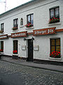 Traditional pub (constructed 1870)
 -
 Postal settlement


Commuters
[edit]Transportation at this time was appreciably poor. Although the population of Lindenthal comprised mainly employees and officials who worked in the centre of Cologne, the city made no plans to construct public transport infrastructure to Lindenthal until its annexation in 1888. The private wagonways established in 1877 (under licence from the government of Prussia, not the city of Cologne) did however encourage further population growth. Around the turn of the century, this wagonway network extended around 63 kilometres and employed over 1,000 workers, 834 hourses, and almost 350 wagons. Approximately 30 million passengers used this network each year.[4]

Between 1890 and 1895, this was augmented by the steam trains transporting the lignite that was being mined at Frechen. Lindenthal subsequently took advantage of this infrastructure, with the city of Cologne acquiring the Cologne-Frechen-Benzelrath Railway in 1904. The "F" line, lovingly referred to as Finchen by locals (a German diminutive of Josephine), later became the number 20, then number 2, and subsequently number 7 Cologne Stadtbahn line.[4][5]
Annexation by Cologne
[edit]As part of the annexation negotiations between the Mayoralty of Efferen and the City of Cologne in April 1888, the rural municipality of Kriel und parts of the Mayoralty of Müngersdorf (Melaten, Weyertal and Linder Höhe) were consolidated into the new district of Köln-Lindenthal. In order to retain a consistent administrative system, Lindenthal followed the example of other districts and was subdivided into the administrative subdistricts 60, 61, and 62.[4]
Creation of the Stadtwald (urban forest)
[edit]
Many residents of the farmsteads surrounding Lindenthal and Kriel, much like Kitschburg manor, had been ecclesial territories and were secularised during the Napoleonic French occupation. In 1894, Cologne purchased Kitschburg with its English landscape garden and the surrounding estates, totalling approximately 150 hectares.[4]
On 4 July 1895, Cologne City Council decided on the basis of a proposal by garden architect Adolf Kowallek to transform the large estate into a historicist park, the Cologne Urban Forest (German: Stadtwald), with sports fields, playgrounds, dense woods, ponds, and canals, as well as hospitality establishments like the Waldschenke inn (pictured) and the Stadtwaldrestaurant in Kitschburg manor.[4]
The project, totalling 2.5 million German mark, was completed around the turn of the centuries, although remodellings and extensions continued until 1910. The area of the modern-day Stadtwald, which also contains the Lindenthal Petting Zoo, runs to 205.3 hectares.[4]
-
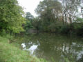
 Canal in the Stadtwald
 -
 Towards Düren Road
 -
 Around Kitschburger Straße
 -
 Lindenthal Canal


Allotments and Green Belt
[edit]An allotment gardens facility was created in Deckstein in 1927-28 in connection with the creation of the outer Green Belt around Deckstein Pond near the mill at Aquarienweg, designed by garden architect Theodor Nußbaum. In its urban design principles, it reflected the ideas of Fritz Schumacher. The latter, in his capacity of city planner under lord mayor Konrad Adenauer, had overseen the razing of the city fortifications from 1920-23, constructing allotment gardens to serve as a new transition zone between residential areas and parkland. This facility comprises 578 allotments and is a heritage listed site. Further allotments, totalling around 5 acres, were built over in the mid-20th century.[4]
-
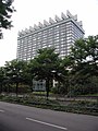
 Former Holiday Inn (2008)
 -
 Stadtwald Pond
 -
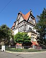 Residence constructed in 1903
 -
 Remains of Kitschburg manor complex


Architecture
[edit]Kitschburg
[edit]1971 saw the opening of the newly built Esso Motor Hotel, subsequently taken over by Holiday Inn but now operated by Leonardo Hotels. Until the construction of this modernen hotel complex at the end of the 1960s, this land was occupied by the classicist stately home of Kitschburg manor. This was constructed in 1814-15, later served as the Stadtwaldrestaurant, and was demolished in 1969. The manorial complex also included a smaller baroque residence (constructed 1759), which today is the only remaining part of the estate.[4]
Urban development 1917–1933
[edit]Construction of public housing began in 1913 under the supervision of GAG Immobilien AG, a joint venture by the City of Cologne, private enterprise, co-operatives, and individuals. The city provided roughly half of the initial capital, and the supervisory board was chaired by the lord mayor of Cologne, Konrad Adenauer. Owing to the First World War and subsequent economic depression, construction activity only began in earnest in 1924 after the end of hyperinflation in the Weimar Republic.[4]


In the late 1920s, Cologne underwent a housing construction boom: entire districts were erected by housing co-operatives mostly according to the urban planning trends of the time, often following garden city principles.[4]
Adenauer's vision as chair of GAG allowed Cologne to pursue one of the most efficient urban housing policy models of the Weimar Republic. Compared to the number of residents, a high proportion of apartment housing constructed was of a particularly high quality, which led to public housing projects in Cologne being described as characterised by "light, air, and trees".[4]
The largely preserved buildings of Wilhelm Riphahns are characteristic of the 1930s construction style. Terraced housing was constructed with the methodical development of remaining open space. Denser residential developments resembling those found in the inner city and Ehrenfeld were constructed as well, but the preference for "green living" largely prevailed. Ornate front yards, mansions embedded within parks, artificial ponds and canals became characteristic of the area.[4]
The Lindenthal Canal with its playgrounds, constructed in 1925, created a connection from the inner green belt to the Stadtwald in the outer green belt. Besides this, Lindenthal boasts many further green spaces owing to former monastic gardens and the large gardens installed for the benefit of the local hospital complexes.[4]

Another example of New Objectivity architecture can be found in the new campus built in Lindenthal for the University of Cologne (refounded 1919), designed in the Werkbund style by Adolf Abel. The groundbreaking ceremony took place in 1929, and the finished campus opened in 1934. As of 2024, serving over 43,000 students, it is one of the largest university campuses in Germany.[4]
Schools
[edit]The single-sex one-room school at Kriel Church gave way in 1865 to a two-room facility providing parallel education for boys and girls. With the area's rapid growth, however, the new school soon ran out of space. The proprietor of Kitschburg manor donated land for a new school in 1875/76. Even this larger building soon had to be expanded due to ever-increasing enrolment, especially because children could also be enrolled from neighbouring Braunsfeld.[4]

The next, even larger school, built in red brick (as was fashionable at the time) by master builder Paul Busse, opened in 1905. In its first year, this modern Volksschule already served 750 pupils. In the spring of 1915, the school was converted into a military hospital for the remainder of World War I.
The later introduction of religious schools led to the construction of a Lutheran school in 1960. The oldest university-preparatory school was the Gymnasium for boys at Gyrhofstraße. The building, which would be completely destroyed in World War II, was constructed as part of the Prussian Reform Movement for approximately 750,000 German mark and inaugurated in 1913 by lord mayor Max Wallraf. Neighbouring Weyertal offered a Gymnasium for girls termed "lyceum" (German: Lyzeum). A school for the deaf was established in 1956 in form of the Johann Joseph Gronewald school.[4]
Monasteries, churches, and hospitals
[edit]
Kriel Church with its estate and leper colony on the territory of today's Melaten cemetery dates to the 13th and 14th centuries and constitute the oldest attested precursors of the later multitude of churches, monasteries, and hospitals in Lindenthal. St Anne's Chapel in Herderstraße is the second-oldest attested church, first mentioned in 1696. The Anna-Haus, originally operated by Cellitinnen (Beguine) sisters from the city proper, retains its Gothic Revival chapel as an extension.[4]
The Church of the Resurrection designed by Gottfried Böhm in 1968 is a renowned building of the post-war period. The variety of Catholic churches in Lindenthal in general offers an excellent overview of different 20th century architectural movements."[6]
Anna-Haus
[edit]
Founded originally as a novitiate convent, Cellitinnen sisters provided in-home care for infirm elderly women from this base. During the World Wars, the sisters provided hospital care to wounded soldiers here. After the Second World War, the building continued to function as a general hospital until 1980.[4]
St Hildegard's Hospital
[edit]A chapel resembling that of the Anna-Haus, which originally belonged to an Alexian monastery, is now part of the St.-Hildegardis-Krankenhaus (St Hildegard's Hospital).[4]
Protestant hospital and orphanage
[edit]
In autumn 1902, a Protestant hospital and orphanage were simultaneously inaugurated in Weyertal. The construction of these was financed from significant donations by well-respected Protestant families in Cologne. This additional hospital in Lindenthal, designed by Alfred Ludwig, was a brick building with pavilion elements and a large garden on an estate measuring 32,000 m². In 1967, the hospital was completely rebuilt, with the addition of a dormitory for students, staff, and apprentices.[4]
Lindenburg (university hospital)
[edit]Johann Heinrich Richartz bequeathed 100,000 thaler to the city of Cologne for the construction of a "sanatorial and care facility", on the condition that it only serve citizens of Cologne. This facility became the "Lindenburg" – which is now Cologne's university hospital. "Lindenburg" originally referred to a 120,000 m² estate of the Hospital Brothers of Saint Anthony. In the space of under 4 years, 35 hospital buildings were constructed at the beginning of the 20th century.[4]
Today, the name Lindenburg is preserved in the name of the nearby public transit stop, German: Lindenburg/Universitätskliniken, lit. 'Lindenburg/University Hospitals'), served by Cologne Stadtbahn line 9. The university hospital also operates an eponymous continuing professional development centre, the Lindenburg-Akademie.
-
 Lindenburg complex, built 1905-1909
 -
 St John the Baptist Church
 -
 Lindenhof
 -
 Inpatient building


St Elizabeth's Hospital
[edit]
St Elizabeth's Hospital (German: St-Elisabeth-Krankenhaus), sometimes referred to as Hohenlind, opened in 1932 as a teaching hospital operated by Caritas Germany. The 171-hectare Hohenlind estate, after which the neighbourhood is also named, contained a knightly manor, a monastic farm, and a watermill.
The largest hospital in western Germany by surface area at the time of its construction, the hospital was praised as "a hospital as it should be". The ecclesial hospital is now another teaching hospital used by the University of Cologne. The interior of Dominikus Böhm's St Elizabeth's Church (German: St-Elisabeth-Kirche) was painted by Ewald Mataré.
Geusenfriedhof cemetery
[edit]The 7,200 m² Geusenfriedhof is a graveyard which, until 1829, served as Cologne's only cemetery for Protestants. Ursula von Gohr zu Kaldenbroek donated the land, then located just outside of the Weyertor city gate, in 1576. The name derives from the Dutch Geuzen refugees who constituted the first significant Protestant minority in Cologne.
Red Church
[edit].JPG)
The Paul Gerhardt Church was consecrated in 1901. It was the first Protestant church in Lindenthal, and is a brick building in the Gothic Revival style.
Because it was not initially given a name, it became colloquially known as the "Red Church" (German: Rote Kirche). It was almost completely destroyed by Allied bombing in 1944. Upon its reconstruction in 1951, it was named after German theologian and hymnodist Paul Gerhardt.
World War II
[edit]
85 % of Lindenthal was destroyed in the Bombing of Cologne in World War II.
A memorial plaque in Dürener Straße commemorates Edith Stein (also known as St Teresa Benedicta of the Cross), a Discalced Carmelite sister of Jewish heritage from Cologne who was murdered at Auschwitz.
Post-war period
[edit]The particularly grave destruction wrought by World War II also affected commerce. It took until the 1970s for Lindenthal's main streets to be fully repopulated by retail businesses. For a time, Lindenthal boasted a cinema (the "Corso"), but as with other suburban cinemas in Cologne, this has not stayed afloat to the present day.
Despite significant protests, the Stadtwaldrestaurant (the former Kitschburg) at the Stadtwald Pond was demolished towards the end of the 1960s and replaced by a hotel.
Present day
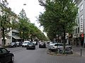
[edit]The main streets of Dürener Straße and Lindenthalgürtel, adjacent to the Stadtwald and the Green Belt, now boast an array of shops, restaurants, cafés, bars, hotels, and banks.
-
 Dürener Straße
 -
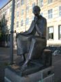 Statue of Albertus Magnus (founder of the university)
 -
 University building
 -
 Reconstructed Jugendstil building


Demographics
[edit]Demographics of Lindenthal (2021)[7]:
- Average age: 42,2 Jahre (Cologne average: 42,3 Jahre)
- Percent immigrants: 10,0 % (Cologne average: 19,3 %)
- Unemployment: 3,1 % (Cologne average: 8,6 %)
Public facilities and museums
[edit]- Lindenthal Borough Hall
- Museum of East Asian Art
- Japanese Cultural Institute
- Italian Consulate and Italian Cultural Institute
Churches and care facilities
[edit]

Unless otherwise stated, the following churches are Roman Catholic.
- Church of the Resurrection
- Kriel Church
- Church of St Albertus Magnus
- Church of St John the Baptist (church of the university hospital)
- Paul Gerhardt Church
- St Stephen's Church
- St Thomas More's Church
- Chapel in the Anna-Haus, Herderstraße
- Chapel at St Hildegard's Hospital
- Protestant Parish of Lindenthal
- Free Protestant Parish of Lindenthal
- Katharina-von-Bora-Haus (elder care facility)
Universities and Schools
[edit]- University of Cologne
- Cologne College of Catholic Theology (KHKT)
- Rhenish School for the Hard of Hearing
- Our Lady School (Catholic Gymnasium)
- Lindenburger Allee Primary School
- Bachemer Straße Primary School
- School of the Furniture Trade
Apostles' Gymnasium
[edit]The Catholic Apostelgymnasium was initially built in 1860 across from the Basilica of the Holy Apostles in Cologne's city centre, but demolished in 1939 in order to construct a new street. After World War II, teaching resumed in a converted former hat factory in Sülz. 1959 saw the groundbreaking for the ceremony of today's building in Lindenthal, where teaching commenced in 1961.
Transportation
[edit]The district is bordered by Aachener Straße and Zülpicher Straße, which lead directly towards the city centre. The former, along with Dürener Straße, connects to the A4 autobahn.
Lindenthal is served by Cologne Stadtbahn light rail lines 1, 7 and 13, and by the 136, 142, 146, 172 and 173 bus lines.[8]
Notable residents
[edit]- Fritz-Otto Busch (1890–1971), naval officer, translator, and author
- Kurt Welter (1916–1949), fighter pilot
- Robin Dutt (* 1965), football coach
Further reading
[edit]- Konrad Adenauer and Volker Gröbe: Lindenthal. Die Entwicklung eines Kölner Vorortes. Bachem, Cologne 2004, ISBN 3-7616-1603-1.
- Konrad Adenauer and Volker Gröbe: Straßen und Plätze in Lindenthal. Köln 1992.
- Ute Fendel: Kulturpfade Köln Lindenthal. Stadt Köln/Bezirksvertretung Lindenthal. Köln 2000.
External links
[edit]References
[edit]- ^ "Lindenthal (Veedel)". koeln.de (in German). Stadt Köln. Retrieved 2024-07-18.
- ^ "Lindenthal (Stadtbezirk)". www.stadt-koeln.de. Stadt Köln. Retrieved 2024-07-18.
- ^ Klug, Clemens (1961). Hürth wie es war, wie es wurde [Hürth as it was, as it became] (in German). Cologne: Heimatverein der Gemeinde Hürth.
- ^ a b c d e f g h i j k l m n o p q r s t u v w x Adenauer, Konrad; Gröbe, Volker (1988). Lindenthal: die Entwicklung eines Kölner Vororts [Lindenthal: the development of a Cologne suburb] (in German). Cologne: Bachem. ISBN 9783761608999.
- ^ Pesch, Matthias (2016-02-16). "Wo ist die Linie 11 geblieben?" (in German). Retrieved 2024-07-18.
- ^ Kier, Hiltrud (2018). Reclams Städteführer Köln: Architektur und Kunst [Reclam's City Guide to Cologne: Architecture and Art] (in German). Stuttgart: Reclam. pp. 252–253. ISBN 9783150195505.
- ^ "Kölner Stadtteilinformationen" (PDF). Stadt Köln, Amt für Stadtentwicklung und Statistik. Retrieved 2023-01-02.
- ^ "Köln/Lindenthal – Reiseführer auf Wikivoyage". de.wikivoyage.org (in German). Retrieved 2024-07-18.
[[Category:Boroughs and quarters of Cologne]]