User:Maaya/Lilienthal translation
| Coat of Arms | Map |
|---|---|

|

|
| Information | |
| Federal State: | Lower Saxony |
| District: | Osterholz |
| Area: | 72.03 km² |
| Population: | 18,214 (December 31, 2004) |
| Population density: | 253/km² |
| Elevation: | 12m above sea level |
| Postal Code: | 28865 |
| Area Code: | 04298 |
| Coordinates: |
53° 8' N, 08° 55' O53° 8' N, 08° 55' O |
| License Plate Code: | OHZ |
| Religion: | 55% Protestant 7% Catholic 38% Other |
| Municipality Address: | Klosterstr. 16 28865 Lilienthal |
| Website: | www.lilienthal.de |
| E-Mail-Adresse: | gemeinde@lilienthal.de |
| Politics | |
| Mayor: | Willy Hollatz (The Green Party) |
The municipality of Lilienthal belongs to the administrative district of Osterholz, Lower Saxony and borders Bremen.
History
[edit]The history of city of Lilienthal goes back to its founding as a monastery by the archbishop Gerhard II. In 1232 construction was begun on a convent of the Order of the Cistercians under the name of Vallis Liliorum, and the finished building was sanctified in 1264. During the 1400s, the cloister enjoyed a time of prosperity. After the Reformation, it became a protestant Center for Women, and until the end of the Thirty Years' War in 1648 it sat in deplorable conditions. In 1650, the city went through secularization. The land once belonging to the monastery, which had become fragmented, developed into the small town of Lilienthal.
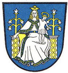
In the meantime, according to the terms of the peace treaty that ended the Thirty Years' War (The Peace of Westphalia), the land between the Weser River and the Elbe now belonged to Sweden. Queen Christina sent one of her commanders over, Graf Friedrich von Hessen-Eschwege, to the newly created soverign state of Osterholz, in which the charge of both Lilienthal and Osterholz were combined. After his early death in 1655, his wife Eleonora took over the ruling of the goverment from Osterholz, where she took an active role in the improvement of economic and sanitary conditions for the rural population. After her death in 1692, the lands fell back into the hands of the Swedish Royalty. Lilienthal remained a part of Sweden until 1712 (which is why the coat of arms contains the blue and yellow of the Swedish Flag), at which time it belonged to Denmark, and then in 1719 it fell under the sovereignty of the kingdom of Hannover.
In 1740, the monastery was destroyed.
In 1782, Johann Hieronymus Schröter became chief magistrate. In addition to this administrative office, he also played a large part in the advancement of astronomy during his lifetime. On the grounds of his office in Lilienthal, he constructed an observatory. In the following years, the Lilienthal Observatory would become the best equipped observatory in the world. One of its technological advances was the "Riesenteleskop" (giant telescope), a telescope with a 50cm aperture and a 8.25 m focal length. Due to the telescope, Lilienthal gained notoriety and was sought out in matters of astronomy by government and military officials. Schröter remained in contact with many of the important astronomers of the time. Together with Wilhelm Olbers and other scholars, he founded the Astronomy Association in Lilienthal in 1800. After Schröter's death in 1816, the observatory fell into disreprair. In 1850 the remaining structure was destroyed. A large part of the observatory was sent to the University of Göttingen before the demolishment.
The Befreiungskrieg (a series of battles fought between 1813 and 1815 that ended the Napoleonic Wars) hit Lilienthal hard. After an incident during a retreat, French troops set the entire town on fire. Only the church, a few houses, and the observatory escaped the flames.
After the reconstruction, the then-municipality grew steadily. In 1939 there were 3,100 inhabitants, in 1974 12,500. After the incorporation of a neighbouring town in the same year, the population grew to 17,000.
In 1866, the kingdom of Hannover lost its independence. Lilienthal became Prussian, the bureaucratic office in Lilienthal was dissolved and combined together with the office in the county of Osterholz.
Schools
[edit]- Christoph-Tornée-School
- All-Day Lilienthal Haupt- and Realschule
- Falkenberg Primary School
- Frankenburg Primary School
- Seebergen Primary School
- Trupermoor Primary School
- Worphausen Primary School
- Gymnasium Lilienthal
- Schroeterschule (Primary School)
Locality
[edit]Today, many former independent districs are now a part of Lilienthal. They include: Butendiek, Falkenberg, Feldhausen, Heidberg, Klostermoor, Lilienthal, Seebergen, St. Jürgen (with ten of its own districts: Frankenburg, Höftdeich, Kleinmoor, Mittelbauer, Moorhausen, Niederende, Oberende, St. Jürgen, Vierhausen, Wührden), Trupe, Truperdeich, Trupermoor und Worphausen (with its villages of Lüningsee (1763), Lüninghausen (1764), Westerwede (1764), Moorende (1778), Mooringen (1778), Schrötersdorf (1805) and Neu Mooringen (1808), which was founded by the royal Moor Colonist Jürgen Christian Findorff).
Twinned Cities
[edit]Since 1970, the municipality of Lilienthal has been twinned to the Dutch municipality of Stadskanaal. In 1993, the city of Emerainville in the vicinity of Paris was added.
References
[edit]Based on the German article [1].
External Links
[edit]- (in German) http://www.lilienthal.de/
- (in German) http://www.lilienthal.tv/
- (in German) http://www.worphausen.de
