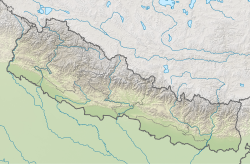
User:JaneIreland1/1988 Nepal earthquake
| Epicentre of earthquake | |
| UTC time | 1988-08-20 23:09:09 |
|---|---|
| ISC event | 429573 |
| USGS-ANSS | ComCat |
| Local date | 21 August 1988 |
| Local time | 04:39:11 NST |
| Magnitude | 6.9 Mw |
| Depth | 57.4 km (35.7 mi) |
| Epicenter | 26°45′18″N 86°36′58″E / 26.755°N 86.616°E |
| Fault | Main Frontal-Himalayan Thrust Indian plate - Eurasian Plate |
| Areas affected | |
| Max. intensity | MMI VIII (Severe) |
| Casualties | 1003 - 1091 Deaths, 9979 injuries |
1988 Nepal earthquake
[edit]The 1988 Nepal earthquake (Nepali: विसं २०४५ को भूकम्प) occurred on the 20/8/1988 at 23:09:09 UTC and 21/08/1988 at 04:39:11 (Indian Standard Time). [1] The earthquake struck primarily eastern Nepal near the Indian border, and affected much of northern Bihar. It extended into central regions of Nepal including Kathmandu Valley. The epicentre was recorded in the Udayapur region of eastern Nepal, 5km from Triyuga. [2] As a result, it is also known as the Udayapur earthquake. The earthquake hit a magnitude of 6.9Mw.[1] This was the largest earthquake to hit the same vicinity in Nepal since the 1934 earthquake.[3] [4] However, since then, Nepal has been devastated by an earthquake of 7.8Mw in April 2015, also known as the Gorkha earthquake. [5]
The earthquake resulted in significant loss of life. The death toll was reported as approximately 1003 - 1091 between Nepal and Northern Bihar. (reuse fujiwari) [6] The subsequent aftermath was worsened by hillside erosion, mudslides and floods, which increased the death toll by almost 300.[7] There was significant damage to buildings and infrastructure, which left up to half a million people homeless and desolated the economy [8] (REF FUj)
The entire region lies above two converging tectonic plates, the Indian plate and the Eurasian plate, which are converging at a rate of 40-50 mm/year. [9] The Indian plate is continuously submerging beneath the Eurasian plate, rendering the entire of Hindu-Kush-Himalaya region prone to earthquakes.[2] This earthquake was caused by a combination of strike-slip and thrust faulting as the plates collide [7]

Within 39 days of the initial earthquake The Department of Mines and Geology recorded 155 aftershocks [7] Six of which had a magnitude greater than 4Mw. [1] [10]
Geographical setting and impact
[edit]Local and international responses
[edit]Short- and longer-term health consequences
[edit]Lessons emerged from this disaster
[edit]See also
[edit]References
[edit]- ^ a b c "M 6.9 - 9 km WSW of Triyuga, Nepal". United States Geological Survey. Retrieved 29 October 2024.
{{cite web}}: CS1 maint: url-status (link) - ^ a b Chaulagain, Hemchandra; Gautam, Dipendra; Rodrigues, Hugo (2018), "Revisiting Major Historical Earthquakes in Nepal", Impacts and Insights of Gorkha Earthquake in Nepal, Elsevier, pp. 1–17, doi:10.1016/b978-0-12-812808-4.00001-8, ISBN 978-0-12-812808-4, retrieved 2024-10-29
- ^ Jain, Sudhir K. (August 1992). "On Better Engineering Preparedness: Lessons from the 1988 Bihar Earthquake". Earthquake Spectra. 8 (3): 391–402. doi:10.1193/1.1585687. ISSN 8755-2930.
- ^ Whelpton, John (2021). "Earthquakes in Nepali History". In Hutt, Michael; Liechty, Mark; Lotter, Stefanie (eds.). Epicentre to aftermath: rebuilding and remembering in the wake of Nepal's earthquakes. Cambridge, United Kingdom ; New York, NY: Cambridge University Press. ISBN 978-1-108-83405-6.
- ^ "M 7.8 - 67 km NNE of Bharatpur, Nepal". United States Geological Survey. 29 October 2024. Retrieved 29 October 2024.
{{cite web}}: CS1 maint: url-status (link) - ^ National Geophysical Data Center / World Data Service (NGDC/WDS) (1972),. "Significant Earthquake Information". National Oceanic & Atmosphere Administration (NOAA). Retrieved November 17, 2024.
{{cite web}}: CS1 maint: extra punctuation (link) CS1 maint: numeric names: authors list (link) CS1 maint: url-status (link) - ^ a b c Pande, M. R.; Nicolas, M. (1991-12-01). "The aftershock sequence of the Udaypur (Nepal) earthquake of August 20, 1988". Journal of Nepal Geological Society. 7. doi:10.3126/jngs.v7i0.32589. ISSN 2676-1378.
- ^ Bista, Dor Bahadur (1989-02). "Nepal in 1988: Many Losses, Some Gains". Asian Survey. 29 (2): 223–228. doi:10.1525/as.1989.29.2.01p0251s. ISSN 0004-4687.
{{cite journal}}: Check date values in:|date=(help) - ^ "USGS Open-File Report 2010‒1083–J: Seismicity of the Earth 1900‒2010 Himalaya and Vicinity". pubs.usgs.gov. Retrieved 2024-11-12.
- ^ Dikshit, A. M. (1991-12-01). "Geological effects and Intensity distribution of the Udayapur (Nepal) earthquake of August 20, 1988". Journal of Nepal Geological Society. 7. doi:10.3126/jngs.v7i0.32588. ISSN 2676-1378.
Cite error: A list-defined reference with the name "ISC-GEM" has been invoked, but is not defined in the <references> tag (see the help page).
Cite error: A list-defined reference with the name "NGDC" has been invoked, but is not defined in the <references> tag (see the help page).
Cite error: A list-defined reference with the name "PAGER-CAT" has been invoked, but is not defined in the <references> tag (see the help page).
External links
[edit]- M6.9 – Nepal-India border region – United States Geological Survey
- Earthquakes in Bihar, India – Amateur Seismic Centre
- The International Seismological Centre has a bibliography and/or authoritative data for this event.


