User:Hp.Baumeler/sandbox
Link aus Bild in English
[edit]
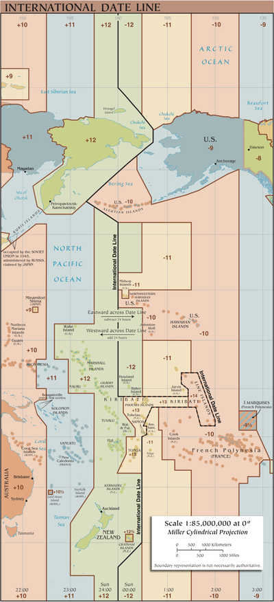
The momentarelly time- and date-situation near the International Date Line
[edit]Die map shows the momentarelly time- and date-situation near the International Date Line on 24. November 2024 at 02:55 o'clock UTC.
Daily from 10:00 UTC to 11:00 UTC on earth exist three different calendar dates. On the map the two red dots indicate the geographical points where these three dates coexist for one hour daily.
Clock
[edit]Die aktuelle Zeit in ![]() Namibia ist: 04:55, 24 November 2024 UTC+02:00 [refresh]
Namibia ist: 04:55, 24 November 2024 UTC+02:00 [refresh]
English Coordinates
[edit]Bahnhof Biasca
Leeding ceros werden ausgedruckt
1) 46°09′21.2″N 008°59′24.7″E / 46.155889°N 8.990194°E uhu
2)22°40′51″S 014°31′17″E / 22.68083°S 14.52139°E
4) 44°06′43″N 87°54′47″W / 44.112°N 87.913°W
5) 44°06′43″N 87°54′47″W / 44.112°N 87.913°W
6) 44°06′43″N 87°54′47″W / 44.112°N 87.913°W
7)
8) 10°N 30°W / 10°N 30°W
9)
| {{coord|10|N|30|W}} | 10°N 30°W / 10°N 30°W |
| {{coord|10|11|N|30|31|W}} | 10°11′N 30°31′W / 10.183°N 30.517°W |
| {{coord|10|11|12|N|30|31|32|W}} | 10°11′12″N 30°31′32″W / 10.18667°N 30.52556°W |
| 10°N 30°W / 10°N 30°W |
10) 46°21′06″N 8°58′29″E / 46.351581°N 8.974758°E
Infobox Olga
[edit]Olga
|
.
Infobox untereinander
[edit]
Hp
|
Hanspeter Baumeler
Wohnhaft im Kanton Wallis in der Schweiz. Ich reise im Privatflugzeug durch Namibia, Südafrika und Botswana. Meine Beiträge an Wikipedia (en/de) sind vor allem Luftaufnahmen aus diesen Ländern.
Living in Canton Wallis, Switzerland. Flying in a private plane through Namibia, South Africa and Botswana. My contributions to Wikipedia are pictures mostly from the bird's eye view.
Habitant du Canton du Valais. Vole en avion privé au-dessus de la Namibie, de l'Afrique du Sud et du Botswana. Je contribue à Wikipedia via mes photos prises essentiellement en vue aérienne.
Time
[edit]The current date and time is 24 November 2024 T 02:55 UTC.
02:55, Sunday, November 24, 2024 (UTC)
| Today is Sunday, 24 November 2024, and the current time is 02:55 (UTC/GMT). There are currently 6,915,080 articles. this page for a new update. |
|
November 24, 2024 Current UTC time and date ()
|
English Coordinates
[edit]VORLAGE:
{{Coord|46|09|21.2|N|008|59|24.7|E|display=inline}}
46°09′21.2″N 008°59′24.7″E / 46.155889°N 8.990194°E
For top of Page Coordinates write display=title: 46°09′21.2″N 008°59′24.7″E / 46.155889°N 8.990194°E
For inline Coordinates write display=inline: 46°09′21.2″N 008°59′24.7″E / 46.155889°N 8.990194°E
For inline Coordinates with Notes: 46°09′21.2″N 008°59′24.7″E / 46.155889°N 8.990194°E uhu
Early Railway Operations
[edit]The Gotthard railway time table from 1899
[edit]
The Gotthard Railway graphic timetable contains a great variety of information with regards to material and especially operational aspects in the year 1899, 17 years after the inauguration of the Gotthard tunnel and completion of the railway. The map key and captions to each column are to be found at the top of the page. Leading from left to right information is given on the location of each station's elevation in relation to sea level, the longitudinal profile, signal lights, tunnels and their length, for each route section on southbound journeys the greatest gradient, distances, employed telegraphs and their networking, signal bells and their connection, telephones, block stations, track layout of the respective station and their equipment, total usable length of the remaining tracks, the longest side track, station names and distances between them, distance to point of origin and between main stations. Departure and arrival times are displayed within the graphic timetable.
Information can be drawn as to the tunnel's vertex which lies at 1154,5 meters above sea level and the fact that the tunnel does not run in a straight line but rather in a slope down from either side of its vertex. The tunnel was designed in such a way that inflowing water would be able to drain. From the railway station of Göschenen to the tunnel's vertex the train lines ascend at an angle of 6 ‰ and descend at 2 ‰ from vertex to the village of Airolo. The tunnel's length is indicated to be 14'998 meters, its vertex being at kilometre 80. It must be noted that the old Gotthard railways' distances were measured from the town of Immensee, as clearly indicated on the graphic timetable.
Electrical Telegraphs and signal bells are listed on the distance column's right and a detailed description thereof is to be found in the chapters The Gotthard railway Telegraph Network and The Gotthard railway Signal Bells.


The track layout of each station shows that in 1899 the Gotthard railway ran on double-tracks from the villages of Flüelen to Giubiasco. Facing north the picture on the right shows the watchman's house at the Mondascia bridge depicts the double-tracks and advance signal to the entry signal before Biasca (at 132.5 km), mentioned in the timetable. The next picture on the right shows the Pianotondo viaduct and the Pianotono-spiral tunnel's upper gate with its watchman's house, which came into use during the days of the double-track steam service, roughly at the time of the graphic timetable's validity.
The graphic timetable sees two tracks running southwards from Giubiasco station. One is signposted "Chiasso", the other "Luino/Locarno". From this point onwards the railway runs on single tracks. Giubiasco's neighbouring stations to the south, Rivera-Bironico and Cadenazzo, are all on single tracks. At each underpass on the Ceneri section it is clearly visible to this day that these were built at greatly different points in time. The Giubiasco-Al Sasso[2] and Al Sasso-Rivera sections were equipped with double-tracks in 1922 and 1934 respectively.
The graphic timetable is a two-dimensional image of the the trains' journeys. Time is displayed horizontally from midnight XII o'clock to midnight XII o'clock. The stations along the journey, from Zug and Lucerne to Chiasso, Locarno and Luino are displayed vertically. The first scheduled train, an express train with 1st, 2nd and 3rd class carriages, leaves Bellinzona at 03:17am. The train with the number 55 is powered by a steam locomotive and, according to the timetable, does not make a scheduled stop at Giubiasco, Rivera-Bironico and Taverne. Arrival at Lugano is scheduled at 04:09am, from where it leaves again at 04:14am. In 1899 the entire train journey from Bellinzona to Lugano was scheduled to be 52 minutes. Today (2017), the same journey on one of the EC trains takes 27 minutes. The illustrations shows that between Giubiasco and Rivera Bironico trains do not pass each other as in 1899 this was, as mentioned in the paragraph above, a single track line. This information can thus be drawn form both, the stations' track layout and the graphic timetable. Also visible on the graphic timetable is the fact that between Osogna and Biasca, trains however do pass each other along their journeys, it being a double-track line. Further, the Arth-Rigi-Bahn's trains (nowadays Rigi Railways), are also listed in the Gotthard railways' timetable. The timetable's scale is 15mm/hour horizontally and 1.75mm/km vertically.
The Gotthard railway Telegraph Network
[edit]
To coordinate trains, the Gotthard railway used a telegraph-network, which linked up all railway stations on the entire line from Luzern to Chiasso, Locarno and Luino. This network is pointed out on the left hand side of the graphic timetable dated 1899. The telegraphs for every railway station shown on the timetable are marked with a black dot. As a detailed section from the timetable shows, the Biasca station used four telegraphs at that time. One of those telegraphs linked all stations from Biasca to Bellinzona. Whatever message was tapped out on this telegraph (sent by morse code), was transmitted to all stations up to Bellinzona. A second telegraph linked all stations from Biasca to Göschenen. What was tapped out on the third telegraph, reached only the railway stations Bellinzona, Faido, Airolo, Göschenen, Wassen and Erstfeld. The fourth telegraph was for long distances. Messages transmitted from there reached Bellinzona, Airolo, Erstfeld, Goldau and Luzern. The telegraphs with their Morse keys and the telegraph-relays were produced by Hasler AG[3] (Bern).
The Gotthard railway Signal Bells
[edit]
The Gotthardbahn employed signal bells within its stations and along the line to signal any approaching train. An alarm was triggered once a train had left a neighbouring station or block station. These signal bells were partly installed along the line and signalled any construction worker an approaching train. In addition, any railway watchman's house and railroad crossing would be equipped with a signal bell. Southbound trains were signalled by 3 triple chimes, northbound trains by two double chimes. The signalling mechanism at each signal bell had to be manually wound up every day by station employees and railway watchmen. Part of the mechanism was a weight having to be raised by help of a pulley. The electric signal triggering the alarm operated a relay, activating the bell's hammer through force of the aforementioned weight. Each signal bell within the Gotthard railway's network is marked on the graphic timetable. The railway watchman's house number 159 (Casello 159) signal bell on the Monte Ceneri line between Giubiasco and Rivera-Bironico is shown as an example in the timetable's excerpt. A southbound train departing Giubiasco for Rivera-Bironico would trigger alarms of eleven different signal bells on its 11 kilometres long journey. Around 1980 these signal bells were decommissioned.
Track maintenance and safety
[edit]
In the Gotthard Railway's early days ultrasound was not available to examine the tracks. Fractures within these were far more common than today, when special ultrasound equipped trains are employed in the maintenance process. The railway watchman was especially important in ensuring the Gotthard railway's safe operation. A railway watchman was assigned to a special segment of tracks which he had to inspect every day. Fractures, deformations and the tracks' general condition were to be reported to the track master. Tending to loose screws and cutting down shrubs were also part of the watchman's job description. Also putting out small shrub fires, caused by the heavily employed brakes of downhill running cargo trains, were part of his duty. The railway watchman was equipped with a red flag to be able to stop trains in an emergency. The Gotthard railway's watchmen lived in specially provided watchman houses along the line. In Italian Language these watchman's houses are called Casello[4]. Every day they had to inspect the tracks up to the the next watchman's segment. The watchman houses were built along the entire Gotthard line with distances of up to 4 kilometres between them and were all numbered. From 1950 onward the track inspections didn't require as many inspections as before. Between Giubiasco and Rivera the railway watchamn then only had to perform such an inspection every other day. Their former watchman houses now remained unmanned and were subsequently used as holiday homes or private dwellings. From 1995 onward the Swiss Federal Railways (SBB) turned to selling these watchman houses.
| Gotthard Railway Double Track[5] | |
|---|---|
| Segment | Opening double track |
| Immensee — Brunnen | 01.05.1904 |
| Brunnen — Sisikon | 15.09.1947 |
| Sisikon — Flüelen | 01.03.1943 |
| Flüelen — Altdorf | 15.01.1896 |
| Altdorf — Erstfeld | 06.12.1896 |
| Erstfeld — Silenen Amsteg | 09.04.1893 |
| Silenen Amsteg — Gurtnellen | 14.05.1893 |
| Gurtnellen — Wassen | 26.06.1892 |
| Wassen — Göschenen | 28.05.1893 |
| Göschenen — Airolo | 01.06.1883 |
| Airolo — Ambri Piotta | 02.09.1890 |
| Ambri Piotta — Rodi Fiesso | 31.07.1890 |
| Rodi Fiesso — Faido | 28.05.1890 |
| Faido — Lavorgo | 13.09.1891 |
| Lavorgo — Giornico | 27.03.1892 |
| Giornico — Bodio | 01.05.1892 |
| Bodio — Biasca | 15.05.1892 |
| Biasca — Osogna | 31.05.1896 |
| Osognia — Bellinzona | 19.04.1896 |
| Bellinzona — Giubiasco | 01.06.1883 |
| Giubiasco — Al Sasso | 20.12.1922 |
| Al Sasso — Rivera Bironico | 21.01.1934 |
| Rivera Bironico — Mezzovico | 27.03.1942 |
| Mezzovico — Taverne Torricella | 02.05.1946 |
| Taverne Torricella — Lugano | 30.04.1942 |
| Lugano — Melide | 10.10.1915 |
| Melide — Bissone | 02.04.1965 |
| Bissone — Maroggia Melano | 03.06.1956 |
| Maroggia Melano — Mendrisio | 01.10.1913 |
| Mendrisio — Chiasso | 01.05.1912 |
References
[edit]- ^ Calculated using parser functions. For more information see WP:CCT. To update time .
- ^ Al-Sasso was a Block Station between Giubiasco and Rivera-Bironico.
- ^ See German Page: Gustav Hasler
- ^ See Italien Page: Casello
- ^ "Der Ausbau auf Doppelspur" (in German). Retrieved 2017-08-23.
Dikwillem
[edit]..... Siehe: Dicker Wilhelm .....
| Dicker Wilhelm | |
|---|---|
 Dicker Wilhelm with Wild Horses in front | |
| Highest point | |
| Elevation | 1,496 m (4,908 ft) |
| Coordinates | 26°28′04″S 016°01′08″E / 26.46778°S 16.01889°E |
| Naming | |
| Native name | Dikwillem Error {{native name checker}}: parameter value is malformed (help) |
| Geography | |
| Location | Namibia |

Dikwillem (Afrikaans) or Dicker Wilhelm (German) , also known as Garub-Berg[1] or Garubberg, is a very striking mountain in Namibia, well visible from a great distance and from all directions. Dikwillem has an elevation of 1496 meters. The mountain lies within the Namib desert, about 15 kilometers north of the National Road B4 and about 80 kilometers east of Lüderitz.
The harsh environment and barren plains around Garub[2] became habitat of the Namib Desert Horses. They are said to be descendants from German cavalry horses and adapted to the conditions and dry climate of the desert. This is very unique.

During the time of German colonial empire a heliographic station was operated by the German Schutztruppe on top of Dikwillem.[3]
References
[edit]- ^ See German Getamap.net
- ^ See German Wikipedia: Garub
- ^ See German Book Stefan Loose Reiseführer Namibia


