User:GalaxyCB
I am a Wikipedia feller who very occasionally makes tiny edits. I quite like shrimps and Bananas sweet things. And if any ops pressure jbizz again ill be angry😡
| en | This user is a native speaker of the English language. |
| This user lives in the United Kingdom. |
Didgeridoo City
[edit]for the updated version, look here User:GalaxyCB/sandbox
City of Didgeridoo | |
|---|---|
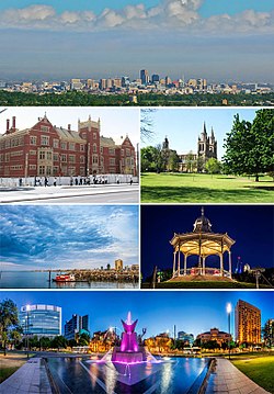
 Clockwise from top: Central Skyline from Didgeridoo City International Airport, Didgeridoo Abbey, A gazebo in Gooseberry Park, Clifton Square, East Lake Tubbé and Asbogger Manor. | |
| Nickname(s): "The city of undecided name", "The Capitalist Dream" | |
| Motto: Latin: "Inaequalem occasionem omnibus" "Unequal opportunity for all" | |
 | |
| Coordinates: 51°30′26″N 0°7′39″W / 51.50722°N 0.12750°W | |
| Sovereign state | Unknown |
| Region | Greater L'Manburg (coterminous) |
| Districts | Central District, Nicoffe District, Soot District, Innit District, Government District |
| Settled by Incans | AD 1461 as Chovenchia |
| Government | |
| • Type | Executive mayoralty and deliberative assembly |
| • Body | Greater Didgeridoo Authority • Mayor Sam Collingbourne (L)(I think? or was he deputy? wait no that was Penrith wasn't it?) • Didgeridoo Assembly |
| Area | |
| • Total | 839 km2 (324 sq mi) |
| • Urban | 1,247 km2 (481 sq mi) |
| • Metro | 1,092 km2 (422 sq mi) |
| • Greater L'Manburg | 1,569 km2 (606 sq mi) |
| Elevation | 1 m (3 ft) |
| Population (2020)[2] | |
| • Total | 2,583,072 |
| • Density | 4,693/km2 (12,150/sq mi) |
| • Urban | 2,787,426 |
| • Metro | 3,257,962 |
| • Greater L'Manburg | 2,583,072 |
| Demonyms | L'Manburger, Burger (informal) |
| GVA (2018) | |
| • Total | £179 Billion |
| • Per capita | £34,283 |
| Time zone | UTC (Greenwich Mean Time) |
| • Summer (DST) | UTC+1 (British Summer Time) |
| Postcode areas | |
| Area codes |
|
| Police | Didgeridoo Constabulary |
| Fire and rescue | Didgeridoo Fire Brigade |
| Ambulance | Terrete's Ambulance service |
| Airports | Didgeridoo City International, Jimmy's Airstrip |
Didgeridoo is the capital city of it's country. Didgeridoo lies 2 miles away from the ocean and is linked to it via the Swag canal. Didgeridoo is 7 miles from the neighbouring city of Mandemville. It is the second largest city in the country after the Big City, the finance capital of the country. The city is strangely very flat for some unknown reason. The city has a large lake called Lake Tubbé in Big Man park. About 2.5 million people reside in L'Manburg, the majority being White L'Manburgers. The most common religion is Christianity with L'Manburg Cathedral being their centre. The driving side is on the right. British English is the official language.
History
[edit]
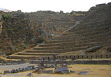
Recent evidence shows early Mayan settlement as early as BC 100, However it is thought that it would have only had numbered a few residents. Most official sources say that a small town had been developed after settlement known as Chovenchia in the Inca Empire. Chovenchia translated to 'city of no swag'. Because of this, King Habooza Schmooza visited and gave the people hope and money. The town was then established in 1490 as Chovemshia, meaning 'city of many swag'. It contained many impressive landmarks and became the fourth city state of the Inca Empire.
It didn't take long for the dam Spaniards to find out, and soon enough they made everyone contract Smallpox and they all bloody died (except the Spaniards). They looted all the gold and silver then left, telling all the other Europeans about so another wave of the stupid cretins like the Frenchies and the Brits came and took a poop on the place. Past travellers describe only ruins. Eventually, the British Army settled there in 1829 and made a large camp with some houses and a farm. This caused irreversible damage to the ruins. The Spanish Empire then occupied everywhere else in the area, surrounding what was by then being called L'Manburg.
Tensions were very high with between the British and the Spanish. This was heightened in 1834, when the Spanish detonated a chain of explosives in L'Manburg territory. The Commander-in-Chief of the Didgeridoo Garrison, Thomas Ennit, Pressed for war whereas the Governor, William Gold, tried to solve the situation diplomaticly. The British Empire then backed Innit and Started a major offensive to Le Manneapolis, the Spanish Capital. It was taken with tough resistance and the Spanish left the area. The British granted the country independence after an armed standoff (between some British generals and Gold and Innit) in 1835, the reason for this remains unknown. This resulted in all of the surrounding area for hundreds of miles being unified with L'Manburg, Becoming known as the country it is today.

Didgeridoo mainly grew from Soldiers bringing their families with them. As such, Many more utilities were constructed. The city suffered a major earthquake in 1873 destroying many ruins of Chovemshia and burring some in earth. Two people were killed in the earthquake. In 1916, amidst the First World War, The capital was changed from the Big City to L'Manburg for security reasons. This was intended to be Temporary at first, but was kept permanently and a new Capitol building was built. During the Second World War, the city had air raid shelters and sirens installed, along with anti aircraft guns. Luckily, no bombs were ever dropped on L'Manburg soil.

A metro system was installed in 1965. During the Mandemville Emergency of 1978, Didgeridoo went on Lockdown and was guarded by the Capital Guard, Numbering about 2,150 soldiers. The 1989 Traveloge Disaster saw 4 people die after an explosion in the kitchen and a resulting fire that gutted much of the building. In 1991 the city's tallest building, Boulmer Plaza, was completed and opened later in the same year. The City Hall was bombed during renovation in 1996, Injuring one maintenance worker. In 2004, The RBJ Corp Building was bombed Killing 13 people and destroying the entire first floor lobby. The person or persons behind the both bombings are thought to be linked. In the 2011 Mayoral election, Alfie Penrith and Sam Collingbourne were narrowly elected as Mayor and Deputy Mayor (god knows who is who), after the Nazi party had mind-controlled nearly half of the voting population. They have been elected to office since.
The COVID-19 Pandemic of 2020 First spread to Didgeridoo in April 2020, spreading rapidly from person to person. As of August 18, the virus has slowed down. In total, 12,844 people in the city have contracted it and 1,639 have died of it. the city went into lockdown on July 2 and many restrictions still apply. City official Rigger Bogger Johnson contracted and died of COVID-19 in July 2020. His services were attended to by hundreds were the mayor (or possibly the deputy mayor) Alfie Penrith made a speech. His son Rigger Bogger Johnson jr. took over his position in the company.
Government
[edit]Since 1916, with the establishment of Didgeridoo being the country's capital, the city has been run as an Executive mayoralty and deliberative assembly. The current Mayor is Sam Collingbourne, or might be Alfie Penrith, unless if he is the Deputy Mayor then in that case I really don't know. The Greater L'Manburg Authority was established in 2000 after the dissolution of the Greater L'Manburg Council. There are currently 42 seats in the Authority. Seats include Treasurer, Secretary of Transport, Chair and Sectretary of Defence.
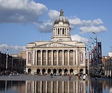
The Headquarters of the country's government is named the Crackin Capitol and is located on the border of the Central District and the Soot District. It was constructed in 1920. The Previous temporary building was the L'Manburg University Building.
Many countries have embassies in Didgeridoo. The largest embassy is the US consulate General. The oldest diplomatic mission is the French embassy.
Geography
[edit]
Didgeridoo can be noted for it's unusually flat surface. The city 2.267 miles from the ocean. since the completion of the Swag Canal in the 1869 the city's fishing economy has boomed. It is the World's only canal where salmon, cod, and tropical fish are housed. There are two major parks Downtown, Big man Park, and Gooseberry Park. Big Man Park contains a large lake measuring 2.1 square miles, named Lake Tubbé, After one of the city's founders.
The Penrith-Collingbourne administration has made many attempts to turn the city into a green Smart City, with some success.
Climate
[edit]L'Manburg Has a temperate climate, usually experiencing warm summers and mild-cold winters.
| Climate data for L'Manburg (1981–2010, extremes 1903–2012) | |||||||||||||
|---|---|---|---|---|---|---|---|---|---|---|---|---|---|
| Month | Jan | Feb | Mar | Apr | May | Jun | Jul | Aug | Sep | Oct | Nov | Dec | Year |
| Record high °C (°F) | 25.0 (77.0) |
26.7 (80.1) |
30.7 (87.3) |
34.0 (93.2) |
36.3 (97.3) |
39.2 (102.6) |
37.6 (99.7) |
30.0 (86.0) |
25.1 (77.2) |
24.6 (76.3) |
19.2 (66.6) |
20.0 (68.0) |
39.2 (102.6) |
| Mean daily maximum °C (°F) | 16.8 (62.2) |
17.2 (63.0) |
19.2 (66.6) |
23.8 (74.8) |
25.6 (78.1) |
32.8 (91.0) |
28.5 (83.3) |
25.7 (78.3) |
19.9 (67.8) |
18.3 (64.9) |
15.1 (59.2) |
14.4 (57.9) |
30.8 (87.4) |
| Daily mean °C (°F) | 12.1 (53.8) |
13.3 (55.9) |
15.9 (60.6) |
18.6 (65.5) |
21.6 (70.9) |
25.0 (77.0) |
24.7 (76.5) |
20.9 (69.6) |
16.9 (62.4) |
14.1 (57.4) |
12.0 (53.6) |
11.5 (52.7) |
19.8 (67.6) |
| Mean daily minimum °C (°F) | 5.3 (41.5) |
8.3 (46.9) |
9.6 (49.3) |
11.2 (52.2) |
15.6 (60.1) |
17.2 (63.0) |
15.9 (60.6) |
13.0 (55.4) |
10.9 (51.6) |
8.9 (48.0) |
6.9 (44.4) |
5.7 (42.3) |
12.9 (55.2) |
| Record low °C (°F) | −2.0 (28.4) |
−1.1 (30.0) |
0.4 (32.7) |
2.1 (35.8) |
5.2 (41.4) |
6.3 (43.3) |
4.0 (39.2) |
3.5 (38.3) |
1.0 (33.8) |
−1.2 (29.8) |
−3.1 (26.4) |
−4.2 (24.4) |
−4.2 (24.4) |
| Average rainfall mm (inches) | 140.3 (5.52) |
109.4 (4.31) |
108.4 (4.27) |
124.7 (4.91) |
158.7 (6.25) |
186.7 (7.35) |
165.0 (6.50) |
170.0 (6.69) |
170.4 (6.71) |
174.8 (6.88) |
138.1 (5.44) |
112.6 (4.43) |
1,759.1 (69.26) |
| Average rainy days (≥ 0.1 mm) | 14 | 12 | 11 | 11 | 16 | 18 | 16 | 15 | 15 | 16 | 16 | 14 | 174 |
| Average relative humidity (%) | 82 | 81 | 78 | 77 | 80 | 82 | 83 | 82 | 82 | 81 | 82 | 81 | 81 |
| Source: PAGASA[5][6] | |||||||||||||
Tingleville upon Severn
[edit]Borough of Tingleville Upon Servern | |
|---|---|
 Saint Chungus' Church of Tingleville | |
| Sovereign state | Unknown |
| Status | Autonomous Commune |
| Ceremonial Borough | Tingleville |
| Government | |
| • Type | Autonomous Mayoral Assembly |
| • Body | Tingleville Borough Council |
| • Leadership | Leader & Cabinet (Social Libertarians) |
| • Mayor | Albert (SP) |
| Area | |
| • Total | 193.7 km2 (74.8 sq mi) |
| Population (2015) | |
| • Total | 82,197 |
| • Rank | 79th (of 296) |
| • Density | 420/km2 (1,100/sq mi) |
| • Ethnicity | 85.6% White L'Manburger 5.4% Other White 3.9% Asian 1.71% Black L'Manburger 2.0% Mixed Race 0.6% Other |
| Time zone | UTC0 (GMT) |
| • Summer (DST) | UTC+1 (BST) |
| Website | sites |
Tingleville Upon Severn', often referred to as simply Tingleville is an autonomous borough of L'Manburg.
History
[edit]Foundation
[edit]Tingleville is believed to have first been inhabited in 1783 By Spanish settlers as a forward scouting base for L'Manburg. The post was attacked on many occasions but the two small armies in the area eventually became ‘friendly’ with each other and henceforth the town grew undisturbed until the fall of Le Manneapolis. Even though most Spanish settlers were kicked out, many architects were kept and the town’s architecture came to be considered some of the finest works of the Spanish colonial era.
Modern History
[edit]At the outbreak of World War 1 in 1914, Camp Rose was established as a garrison for the protection of L'Manburg. At it's height, the camp boasted more than 19,000 soldiers and 6 aircraft. The camp was drastically scaled in 1926 to what was basically a backup runway for the air force. Redundant soldiers then moved permanently into Tingleville looking for jobs and repopulating the city.
Tingleville Explosion
[edit]On dusk of Tuesday November 6, 2020 an Islamic Extremist detonated a chain of the explosive weapon trinitrotoluene, in what became known as the Tingleville Explosion. As many 374 people were killed and up to 10,684 injured. The disaster amounted to an estimated 7 billion Pound Sterling in cost. Gas and water mains were ruptured for as far back as Le Manneapolis. The perpetrator has yet to be found.
Notable buildings and structures damaged include:
- Tingleville Municipal Building (completely destroyed)
- Gastrointestinal Mall (completely destroyed)
- Tingleville Centre Community Fire and Rescue Station (completely destroyed)
- Ned Bridge
- Flecca Bank
Geography
[edit]Tingleville contains a strangely complex and varied climate, which has puzzled researchers for centuries. It contains three different microclimates. These are the Alpaca Desert, Llanuras and Toundra D'Làce.
To do
[edit]- Cardinal Telephone Exchange
- Moresby Tower
- Vale House
- The Madison, London
- David Murray John Tower
- Bank Tower 2
- Two Fifty One -IMPORTANT-
- ^ "London weather map". The Met Office. Archived from the original on 3 August 2018. Retrieved 26 August 2018.
- ^ Cite error: The named reference
ons-pop-estimateswas invoked but never defined (see the help page). - ^ "Regional economic activity by gross domestic product, UK: 1998 to 2018". www.ons.gov.uk.
- ^ Sub-national HDI. "Area Database – Global Data Lab". hdi.globaldatalab.org.
- ^ "Davao City, Davao del Sur Climatological Normal Values". Philippine Atmospheric, Geophysical and Astronomical Services Administration. Archived from the original on 2 October 2018. Retrieved 1 October 2018.
- ^ "Davao City, Davao del Sur Climatological Extremes". Philippine Atmospheric, Geophysical and Astronomical Services Administration. Archived from the original on 2 October 2018. Retrieved 1 October 2018.


