User:Djondjon1804/sandbox
{{Regions of Haiti}}
| Regions or Commonwealth of Haiti (English) Konbit d'Ayiti (Ayisyen) Régions d'Haiti (French) Región de Haití (Spanish) | |
|---|---|
| Category | Country in the Caribbean |
| Location | Republic of Haiti |
| Number | 4 regions |
| Populations | more than 12 millions |
| Areas | 27 800 km2 |
| Government | |
| Subdivisions | |
Haiti is divided into four regions. All four regions are further subdivised into ten departments. Regions have no administrative power in Haiti under the current Constitution, altho federalism is a growing subject in the Haitian social, economical and political sphere.
Overview
[edit]The Republic of Haiti is separated into 4 regions:
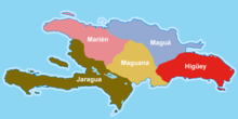
- The Marien (Maryen : Haitian Creole)or Nothern Region
- Composed of the departments along the Atlantic Ocean such as Nord-Ouest, Nord, and Nord-Est
- The Artibonite (Latibonit : Haitian Creole)or Central Region
- Composed of the departments along the Artibonite River such as Artibonite and Centre
- The Gonave-Azuei (Gonavazwey : Haitian Creole)Region or Western Region;
- Composed of the departments along the Gulf of Gonave such as the West
- The Xaragua (Ksaragoàn : Haitian Creole)or Southern Region;
- Composed of the departments along the Caribbean Sea such as the Nippes, Grand'Anse, Sud, and Sud-Est
Etymology
[edit]Traditionally each region is reffered to by the geographical position such as North, West or South. Those regions are to officially be renamed after a Taino kasika like Marien and Xaragua or a Taino settlement like Artibonite and Gonave-Azuei.
The term konbit is Haitian Creole referring to a cooperative communal labor, it is the bases of Haitian farmer working system. In this context it refers to multiple departments forming a union for legislative and economical success.
Description
[edit]Administrative regions can also be seen as developed regions and are to be used to organize the delivery of provincial government services and coordinate the different departments which share common topographic realities, economical opportunities, and cultural values.

Administrative Regions
[edit]The capitals or chef-lieu régional are carefully chosen to match historical realities and outside of the economic center of the regions to lower the risk of corruption.
The District of Port-au-Prince should have special status as the country's capital.
| Region | Population | Capital | Biggest city | Land area (km2) | Other notable cities |
|---|---|---|---|---|---|
| Marien | 2 399 422 | Milot | Cap-Haitian | 5690 | Fort-Liberté, Ouanaminthes, Port-de-Paix, Mole-Saint-Nicolas |
| Artibonite | 2 755 573 | Dessalines | Gonaives | 8266 | St-Marc, Petite-Riviere, Hinche, Mirebalais |
| Gonave-Azuei | 3 769 614 | Port-au-Prince | Port-au-Prince | 4650 | Arcahaie, Croix-des-Bouquets, Carrefour, Pétionville, Léogane, Petit-Goave |
| Xaragua | 2 218 403 | Platons | Les Cayes | 7532 | Miragoanes, Jacmel, Jeremi |
Precedence
[edit]Although Haiti's government is modeled after France as a unitary republic with a bicameral parliament system, many events in the country's history suggest that its government should instead be a federation.
Taino Period
[edit]The administrative task of the Taino was split between the five chiefdoms of Ayiti.
French Period
[edit]The colony followed the unitary system, the tasks were split between a governor representing the king of France and the vice-intendant in charge of internal affairs. The colony was divided into 3 big departments.
Although the colony had its own assembly no decision could be taken with Metropol France having the last word.
Haitian Period
[edit]With the Constitution of 1805, Hayti was a centralized monarchy distributed into 6 division-militaire but articles 15 to 17 granted each one certain level of autonomy but rallying them under the Empire.
After 1806 the country was formally separated into 4 states each one having:
| Flag | Type | Region | Name | Government | Leader | Capital | Constitution | Military command | Law | Legislative body | Higher learning | |
|---|---|---|---|---|---|---|---|---|---|---|---|---|
 |
de-jure | North | Kingdom of Hayti | Monarchy | Henry, Henry 1st, Christophe | Milot | Royal Constitution of 1811 | Royal Dahomey | Code Henry | État Major | Royal Academy | |
 |
de-jure | West | Republic of Hayti | Republic | Alexandre Pétion | Port-au-Prince | Constitution of 1806, 1811 | Armée | Code Rurale | Sénat | Académie de Port-au-Prince and Lycée Nationale | |
 |
de-facto | South | Meridionnal Republic of Hayti | Republic | André Rigaud | Les Cayes | - | - | - | - | - | - |
 |
de-facto | Grand'Anse | the Grand'Anse | Monarchy-Lakou | Goman | Grand-Doco | - | - | - | - | - | - |
Later on during the Salnave Civil War the country was then again split into 3 de-facto states with Nissage Saget in the North, Sylvain Salnave in the West, and Michel Domingue in the South.

Context
[edit]Many Haitian scholars have hinted at a federation for Haiti with suggestions ranging from the federations of the Arrondissement to the federation of Departments. These suggestions are not seriously debated in the Haitian Parliament.
In 2022 Haiti is yet again at a crossroads with
- no president
- Constitutional vacuum with multiple President and Senator pointing it as a source of instability
- Political and Economic groups involved in gang activities
- The main arteries extending from Port-au-Prince are cut isolating it and triggering some sentiments of regionalism.
Federation and Konbitism
[edit]Advantages
[edit]Politics and Governability
[edit]Competencies
[edit]Economic
[edit]Application
[edit]See also
[edit]- Administrative divisions of Haiti
- Government of Haiti
- Departments of Haiti
- Geography of Haiti
- List of federated states
