Untersiebenbrunn
Appearance
Untersiebenbrunn | |
|---|---|
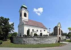
 Saint Vitus Church | |
| Coordinates: 48°15′N 16°43′E / 48.250°N 16.717°E | |
| Country | Austria |
| State | Lower Austria |
| District | Gänserndorf |
| Government | |
| • Mayor | Reinhold Steinmetz (SPÖ) |
| Area | |
• Total | 30.49 km2 (11.77 sq mi) |
| Elevation | 158 m (518 ft) |
| Population (2018-01-01)[2] | |
• Total | 1,736 |
| • Density | 57/km2 (150/sq mi) |
| Time zone | UTC+1 (CET) |
| • Summer (DST) | UTC+2 (CEST) |
| Postal code | 2284 |
| Area code | 02286 |
Untersiebenbrunn is a town in the district of Gänserndorf in the Austrian state of Lower Austria.
The town's Catholic Church is part of the Archdiocese of Vienna, and the Marchfeld group of parishes, under the patronage of Melk Abbey.[3]
The Hubertus Kapelle (chapel) on Siebenbrunnerstrasse commemorates the Huburtus deer hunt.
Population
[edit]| Year | Pop. | ±% |
|---|---|---|
| 1869 | 424 | — |
| 1971 | 1,299 | +206.4% |
| 1981 | 1,271 | −2.2% |
| 1991 | 1,300 | +2.3% |
| 2001 | 1,400 | +7.7% |
| 2011 | 1,467 | +4.8% |
References
[edit]- ^ "Dauersiedlungsraum der Gemeinden Politischen Bezirke und Bundesländer - Gebietsstand 1.1.2018". Statistics Austria. Retrieved 10 March 2019.
- ^ "Einwohnerzahl 1.1.2018 nach Gemeinden mit Status, Gebietsstand 1.1.2018". Statistics Austria. Retrieved 9 March 2019.
- ^ "Pfarre Untersiebenbrunn". Archdiocese of Vienna (in German). Retrieved 6 April 2023.
External links
[edit]


