Untergiesing-Harlaching

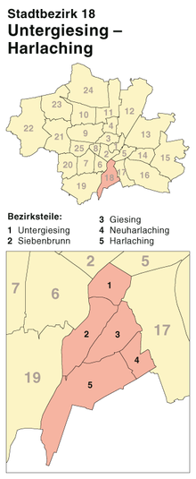
Untergiesing-Harlaching (Central Bavarian: Untagiasing-Harlaching) is the 18th borough of Munich, Germany, mostly the districts of Untergiesing and Harlaching. The borough's western border is the river Isar, in the south it borders on Grünwald and the Perlacher Forst [German-language Wiki: Perlacher Forst] (Perlach Forest), to the north-west on the Munich borough of Obergiesing and to the north on the borough of Au-Haidhausen.
Subdivisions
[edit]Untergiesing
[edit]
Untergiesing comprises the borough's northern end, limited by the river in the west, the high cliff on the east, the Humboltstraße to the north, and the Candidstraße, part of Munich's Mittlerer Ring ring road system, to the south.
Siebenbrunn
[edit]Siebenbrunn is located south of Untergiesing, sandwiched between the high cliff to the east and the river to the west. An important landmark is the Tierpark Hellabrunn (Munich Zoo), located in the district's south-west area, on the river.

Harlaching and Neuharlaching
[edit]The hospital Klinikum Harlaching, which opened on 18 November 1899, is located in the Harlaching district.
