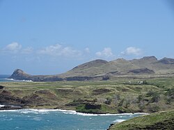
Ua Huka Airport
Appearance
Ua Huka Airport | |||||||||||
|---|---|---|---|---|---|---|---|---|---|---|---|
 | |||||||||||
| Summary | |||||||||||
| Airport type | Public | ||||||||||
| Serves | Hane, Ua Huka | ||||||||||
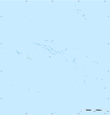
| Location | Marquesas Islands, French Polynesia | ||||||||||
| Elevation AMSL | 160 ft / 49 m | ||||||||||
| Coordinates | 08°56′06.7″S 139°33′18.4″W / 8.935194°S 139.555111°W | ||||||||||
| Map | |||||||||||
 | |||||||||||
| Runways | |||||||||||
| |||||||||||
Sources: Great Circle Mapper [1] | |||||||||||
Ua Huka Airport is an airport on Ua Huka in French Polynesia (IATA: UAH, ICAO: NTMU). The airport is 2.2 km southwest of the village of Hane. The airport was opened on November 4, 1970, with the first landings made by an Air Tahiti Piper Aztec and an RAI Twin Otter.[2] Commercial flights began in 1971.[2] As of 2021 it received 1600 passengers a year.[3]
Airlines and destinations
[edit]| Airlines | Destinations |
|---|---|
| Air Tahiti | Atuona, Nuku Hiva, Ua Pou |
Statistics
[edit]Graphs are unavailable due to technical issues. Updates on reimplementing the Graph extension, which will be known as the Chart extension, can be found on Phabricator and on MediaWiki.org. |
Annual passenger traffic at UAH airport.
See Wikidata query.
References
[edit]- ^ Great Circle Mapper - Ua Huka Airport
- ^ a b "Air Link Opens To "Forgotten" Marquesas". Pacific Islands Monthly. Vol. 41, no. 12. 1 December 1970. p. 39. Retrieved 12 March 2022 – via National Library of Australia.
- ^ "Statistiques annuelles: Aéroport de Ua Huka". UAF&FA. Retrieved 24 November 2022.
External links
[edit]- NTMU – UA HUKA. AIP from French Service d'information aéronautique, effective 23 January 2025.

