Thulaim
Thulaim
ثليم | |
|---|---|
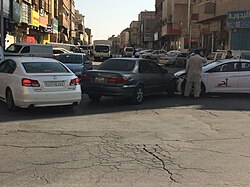
 Vehicle collision in Thulaim, around 2016 | |
| Coordinates: 24°38′28″N 46°43′37″E / 24.64111°N 46.72694°E | |
| Country | |
| City | Riyadh |
| Region | Old Riyadh |
| Named for | Thulaim Palace |
| Government | |
| • Body | Baladiyah al-Malaz |
| Language | |
| • Official | Arabic |
Thulaim (Arabic: ثليم, romanized: ṯulaīm) is a commercial and residential neighborhood in downtown Riyadh, Saudi Arabia, located south of al-Amal and north of Margab in the sub-municipality of al-Malaz,[1] situated on the edge of now dried up stream of Wadi al-Batʼha.[2] The neighborhood is bounded by the al-Batʼha Street to the west, constituting its westernmost part in the al-Batʼha commercial area and is today inhabited mostly by overseas workers from India, Pakistan and Bangladesh. It is named after the Thulaim Palace,[3] which was itself attributed to an eponymous farm on which it was built by King Abdulaziz ibn Saud in present-day al-Fouta district in late 1930s.
Owing to its visible furrows (Arabic: ثُلَم, lit. 'gaps') during medieval Najd, one historical account suggests that the area might've been referred to as al-Thalama (Arabic: الثلماء) during the existence of Hajr al-Yamamah, which was recorded in a poem by 8th century Abbasid poet Sulayman ibn Abi Hafsa.[4][5]
References
[edit]- ^ مشاريع النظافة، أمانة منطقة الرياض، الإدارة العامة للنظافة(مؤرشف). Archived 2016-09-29 at the Wayback Machine
- ^ محمود, محمدين، محمد (1992). أسماء الأماكن في المملكة العربية السعودية: دراسة في الدلالة وأنماط الاشتقاق (in Arabic). [د.ن.]،.
- ^ الثعلي, عتيبي، إبراهيم بن عويض (1996). الأمن في عهد الملك عبد العزيز: تطوره وآثاره، ٩١٣١-٣٧٣١ ھ/٢٠٩١-٣٥٩١ م (in Arabic). مكتبة الملك عبد العزيز العامة،. ISBN 978-9960-624-19-8.
- ^ Sulaymān, Khālid ibn Aḥmad; أحمد, سليمان، خالد بن (1999). معجم مدينة الرياض (in Arabic). دارة الملك عبد العزيز،. ISBN 978-9960-693-11-8.
- ^ "أحياء وشوارع الرياض القديمة.. التاريخ وثّق الأسماء ل "جيل الألفية"!". www.alriyadh.com. 20 May 2011. Retrieved 24 May 2023.

