Jump to content

Template:Infobox Greece place/testcases

Coordinates: 36°55′N 22°40′E / 36.917°N 22.667°E / 36.917; 22.667
From Wikipedia, the free encyclopedia
Side by side comparison
{{Infobox Greece place}}{{Infobox Greece place/sandbox}}
Athens
Αθήνα
Athīna
Settlement
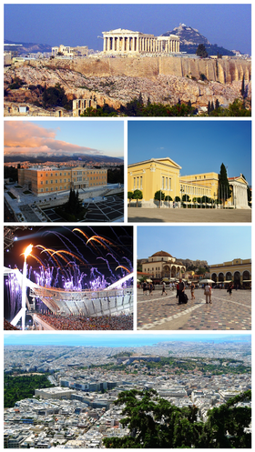
From upper left: the Acropolis, the Hellenic Parliament, the Zappeion, the Acropolis Museum, Monastiraki Square, Athens view towards the sea.
Athens is located in Greece
Athens
Athens
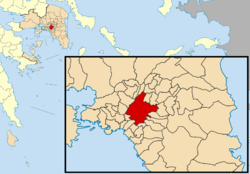
Location within the region
Coordinates: 37°58′N 23°43′E / 37.967°N 23.717°E / 37.967; 23.717
CountryGreece
Geographic regionCentral Greece
Administrative regionAttica
Regional unitCentral Athens
Districts7
Government
 • MayorGiorgos Kaminis (Independent; since 29 December 2010)
Area
 • Urban
412 km2 (159 sq mi)
 • Metro
2,928.717 km2 (1,130.784 sq mi)
Highest elevation
338 m (1,109 ft)
Lowest elevation
70 m (230 ft)
Population
 (2011)[1]
 • Urban
4,013,368
 • Urban density9,700/km2 (25,000/sq mi)
 • Metro
3,752,973
 • Metro density1,300/km2 (3,300/sq mi)
DemonymAthenian
Time zoneUTC+2 (EET)
 • Summer (DST)UTC+3 (EEST)
Postal code
10x xx, 11x xx, 120 xx
Area code(s)21
Vehicle registrationYxx, Zxx, Ixx (excluding ZAx and INx)
Websitewww.cityofathens.gr
Athens
Αθήνα
Athīna
Settlement
From upper left: the Acropolis, the Hellenic Parliament, the Zappeion, the Acropolis Museum, Monastiraki Square, Athens view towards the sea.
Athens is located in Greece
Athens
Athens
Location within the region
Coordinates: 37°58′N 23°43′E / 37.967°N 23.717°E / 37.967; 23.717
CountryGreece
Geographic regionCentral Greece
Administrative regionAttica
Regional unitCentral Athens
Districts7
Government
 • MayorGiorgos Kaminis (Independent; since 29 December 2010)
Area
 • Urban
412 km2 (159 sq mi)
 • Metro
2,928.717 km2 (1,130.784 sq mi)
Highest elevation
338 m (1,109 ft)
Lowest elevation
70 m (230 ft)
Population
 (2011)[1]
 • Urban
4,013,368
 • Urban density9,700/km2 (25,000/sq mi)
 • Metro
3,752,973
 • Metro density1,300/km2 (3,300/sq mi)
DemonymAthenian
Time zoneUTC+2 (EET)
 • Summer (DST)UTC+3 (EEST)
Postal code
10x xx, 11x xx, 120 xx
Area code(s)21
Vehicle registrationYxx, Zxx, Ixx (excluding ZAx and INx)
Websitewww.cityofathens.gr
Side by side comparison
{{Infobox Greece place}}{{Infobox Greece place/sandbox}}
Larissa
Λάρισα
Settlement
The first ancient theatre of Larissa
Larissa is located in Greece
Larissa
Larissa
Location within the region
Coordinates: 39°38.5′N 22°25′E / 39.6417°N 22.417°E / 39.6417; 22.417
CountryGreece
Administrative regionThessaly
Regional unitLarissa
Districts4+1
Government
 • MayorKonstantinos Tzanakoulis (ND; since 1998)
Area
 • Municipal unit122.6 km2 (47.3 sq mi)
Elevation
67 m (220 ft)
Population
 (2011)[1]
 • Municipal unit
146,926
 • Municipal unit density1,200/km2 (3,100/sq mi)
Time zoneUTC+2 (EET)
 • Summer (DST)UTC+3 (EEST)
Postal code
41x xx
Area code(s)241
Vehicle registrationΡΙ,ΡΡ
Websitewww.larissa-dimos.gr
Larissa
Λάρισα
Settlement
The first ancient theatre of Larissa
Larissa is located in Greece
Larissa
Larissa
Location within the region
Coordinates: 39°38.5′N 22°25′E / 39.6417°N 22.417°E / 39.6417; 22.417
CountryGreece
Administrative regionThessaly
Regional unitLarissa
Districts4+1
Government
 • MayorKonstantinos Tzanakoulis (ND; since 1998)
Area
 • Municipal unit122.6 km2 (47.3 sq mi)
Elevation
67 m (220 ft)
Population
 (2011)[1]
 • Municipal unit
146,926
 • Municipal unit density1,200/km2 (3,100/sq mi)
Time zoneUTC+2 (EET)
 • Summer (DST)UTC+3 (EEST)
Postal code
41x xx
Area code(s)241
Vehicle registrationΡΙ,ΡΡ
Websitewww.larissa-dimos.gr
Side by side comparison
{{Infobox Greece place}}{{Infobox Greece place/sandbox}}
Edessa
Έδεσσα
Edessa's waterfalls, landmark of the town
Edessa is located in Greece
Edessa
Edessa
Location within the region
Coordinates: 40°48′N 22°3′E / 40.800°N 22.050°E / 40.800; 22.050
CountryGreece
Geographic regionMacedonia
Administrative regionCentral Macedonia
Regional unitPella
Districts15
Government
 • MayorDimitris Giannou (ND; since 2011)
Area
 • Municipality
611.212 km2 (235.990 sq mi)
 • Municipal unit321.2 km2 (124.0 sq mi)
 • Community39.0 km2 (15.1 sq mi)
Elevation
320 m (1,050 ft)
Population
 (2021)[2]
 • Municipality
26,407
 • Density43/km2 (110/sq mi)
 • Municipal unit
23,210
 • Municipal unit density72/km2 (190/sq mi)
 • Community
19,036
 • Community density490/km2 (1,300/sq mi)
Time zoneUTC+2 (EET)
 • Summer (DST)UTC+3 (EEST)
Postal code
582 00
Area code(s)23810
Vehicle registrationΕΕ
Websitedimosedessas.gov.gr
Edessa
Έδεσσα
Edessa's waterfalls, landmark of the town
Edessa is located in Greece
Edessa
Edessa
Location within the region
Coordinates: 40°48′N 22°3′E / 40.800°N 22.050°E / 40.800; 22.050
CountryGreece
Geographic regionMacedonia
Administrative regionCentral Macedonia
Regional unitPella
Districts15
Government
 • MayorDimitris Giannou (ND; since 2011)
Area
 • Municipality
611.212 km2 (235.990 sq mi)
 • Municipal unit321.2 km2 (124.0 sq mi)
 • Community39.0 km2 (15.1 sq mi)
Elevation
320 m (1,050 ft)
Population
 (2021)[2]
 • Municipality
26,407
 • Density43/km2 (110/sq mi)
 • Municipal unit
23,210
 • Municipal unit density72/km2 (190/sq mi)
 • Community
19,036
 • Community density490/km2 (1,300/sq mi)
Time zoneUTC+2 (EET)
 • Summer (DST)UTC+3 (EEST)
Postal code
582 00
Area code(s)23810
Vehicle registrationΕΕ
Websitedimosedessas.gov.gr
Side by side comparison
{{Infobox Greece place}}{{Infobox Greece place/sandbox}}
Irakleio
Ηράκλειο
Settlement
Irakleio is located in Greece
Irakleio
Irakleio
Coordinates: 40°45.4′N 23°2.2′E / 40.7567°N 23.0367°E / 40.7567; 23.0367
CountryGreece
Administrative regionCentral Macedonia
Regional unitThessaloniki
MunicipalityLagkadas
Municipal unitLagkadas
Area
 • Total
9.825 km2 (3.793 sq mi)
Elevation
105 m (344 ft)
Population
 (2021)[2]
 • Total
1,171
 • Density120/km2 (310/sq mi)
Time zoneUTC+2 (EET)
 • Summer (DST)UTC+3 (EEST)
Postal code
572 00
Area code(s)+30-2394-xxx-xxx
Vehicle registrationNAx-xxxx to NXx-xxxx
Irakleio
Ηράκλειο
Settlement
Irakleio is located in Greece
Irakleio
Irakleio
Coordinates: 40°45.4′N 23°2.2′E / 40.7567°N 23.0367°E / 40.7567; 23.0367
CountryGreece
Administrative regionCentral Macedonia
Regional unitThessaloniki
MunicipalityLagkadas
Municipal unitLagkadas
Area
 • Total
9.825 km2 (3.793 sq mi)
Elevation
105 m (344 ft)
Population
 (2021)[2]
 • Total
1,171
 • Density120/km2 (310/sq mi)
Time zoneUTC+2 (EET)
 • Summer (DST)UTC+3 (EEST)
Postal code
572 00
Area code(s)+30-2394-xxx-xxx
Vehicle registrationNAx-xxxx to NXx-xxxx
Side by side comparison
{{Infobox Greece place}}{{Infobox Greece place/sandbox}}
Thisvi
Θίσβη
Thisvi is located in Greece
Thisvi
Thisvi
Location within the regional unit
Coordinates: 38°16′N 22°58′E / 38.267°N 22.967°E / 38.267; 22.967
CountryGreece
Administrative regionCentral Greece
Regional unitBoeotia
MunicipalityThebes
Area
 • Municipal unit245.492 km2 (94.785 sq mi)
 • Community39.350 km2 (15.193 sq mi)
Population
 (2021)[2]
 • Municipal unit
2,367
 • Municipal unit density9.6/km2 (25/sq mi)
 • Community
337
 • Community density8.6/km2 (22/sq mi)
Time zoneUTC+2 (EET)
 • Summer (DST)UTC+3 (EEST)
Vehicle registrationΒΙ
Thisvi
Θίσβη
Thisvi is located in Greece
Thisvi
Thisvi
Location within the regional unit
Coordinates: 38°16′N 22°58′E / 38.267°N 22.967°E / 38.267; 22.967
CountryGreece
Administrative regionCentral Greece
Regional unitBoeotia
MunicipalityThebes
Area
 • Municipal unit245.492 km2 (94.785 sq mi)
 • Community39.350 km2 (15.193 sq mi)
Population
 (2021)[2]
 • Municipal unit
2,367
 • Municipal unit density9.6/km2 (25/sq mi)
 • Community
337
 • Community density8.6/km2 (22/sq mi)
Time zoneUTC+2 (EET)
 • Summer (DST)UTC+3 (EEST)
Vehicle registrationΒΙ
Side by side comparison
{{Infobox Greece place}}{{Infobox Greece place/sandbox}}
Laconia
Περιφερειακή ενότητα
Λακωνίας
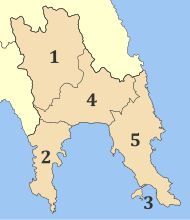
Municipalities of Laconia
Laconia is located in Greece
Laconia
Laconia
Laconia within Greece
Coordinates: 36°55′N 22°40′E / 36.917°N 22.667°E / 36.917; 22.667
CountryGreece
Administrative regionPeloponnese
SeatSparta
Area
 • Total
3,636 km2 (1,404 sq mi)
Population
 (2021)[2]
 • Total
84,337
 • Density23/km2 (60/sq mi)
DemonymLaconian(s)
Time zoneUTC+2 (EET)
 • Summer (DST)UTC+3 (EEST)
Postal code
23x xx
Area code(s)273x0
Vehicle registrationΑΚ
Laconia
Περιφερειακή ενότητα
Λακωνίας
Municipalities of Laconia
Laconia is located in Greece
Laconia
Laconia
Laconia within Greece
Coordinates: 36°55′N 22°40′E / 36.917°N 22.667°E / 36.917; 22.667
CountryGreece
Administrative regionPeloponnese
SeatSparta
Area
 • Total
3,636 km2 (1,404 sq mi)
Population
 (2021)[2]
 • Total
84,337
 • Density23/km2 (60/sq mi)
DemonymLaconian(s)
Time zoneUTC+2 (EET)
 • Summer (DST)UTC+3 (EEST)
Postal code
23x xx
Area code(s)273x0
Vehicle registrationΑΚ
  1. ^ a b c d "Απογραφή Πληθυσμού - Κατοικιών 2011. ΜΟΝΙΜΟΣ Πληθυσμός" (in Greek). Hellenic Statistical Authority.
  2. ^ a b c d e f g h "Αποτελέσματα Απογραφής Πληθυσμού - Κατοικιών 2021, Μόνιμος Πληθυσμός κατά οικισμό" [Results of the 2021 Population - Housing Census, Permanent population by settlement] (in Greek). Hellenic Statistical Authority. 29 March 2024.