Tangjiakou Subdistrict
Appearance
Tangjiakou Subdistrict
唐家口街道 | |
|---|---|
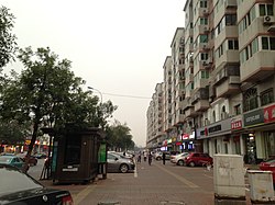
 Chenglin Avenue within the subdistrict, 2016 | |
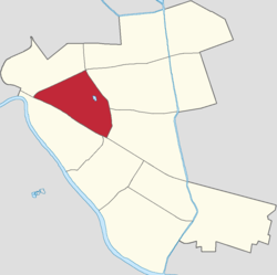
 Location of Tangjiakou Subdistrict within Hedong District | |
| Coordinates: 39°07′40″N 117°14′06″E / 39.12778°N 117.23500°E | |
| Country | China |
| Municipality | Tianjin |
| District | Hedong |
| Village-level Divisions | 12 communities |
| Area | |
• Total | 2.8 km2 (1.1 sq mi) |
| Elevation | 7 m (23 ft) |
| Population (2010) | |
• Total | 72,845 |
| • Density | 26,000/km2 (67,000/sq mi) |
| Time zone | UTC+8 (China Standard) |
| Postal code | 300160 |
| Area code | 022 |
Tangjiakou Subdistrict (Chinese: 唐家口街道; pinyin: Tángjiākǒu Jiēdào) is a subdistrict located on the western side of Hedong District, Tianjin. it borders Xiangyanglou and Shanghang Road Subdistricts to its east, Dazhigu and Dawangzhuang Subdistricts to its south, and Chunhua Subdistrict to its northwest. It had a total population of 72,845 as of 2010.[1]
Its name can be translated as "Tang family's Gate".
History
[edit]| Year | Status | Belong to |
|---|---|---|
| 1956 - 1961 | Tangjiakou Subdistrict | Hedong District, Tianjin |
| 1961 - 1963 | Tangjiakou People's Commune | |
| 1963 - 1966 | Tangjiakou Subdistrict | |
| 1966 - 1968 | Dongfeng District, Tianjin | |
| 1968 - 1978 | Tangjiakou Revolutionary Committee | Hedong District, Tianjin |
| 1978 - present | Tangjiakou Subdistrict |
Administrative divisions
[edit]By the end of 2021, Tangjiakou Subdistrict administered 12 communities. They are, by the order of their Administrative Division Codes:[3]
| Subdivision Names | Name Transliterations |
|---|---|
| 唐家口南里 | Tangjiakou Nanli |
| 新开路 | Xinkailu |
| 嘉华里 | Jiahuali |
| 红星路 | Hongxinglu |
| 唐家口新村六段 | Tangjiakou Xincun Liuduan |
| 长征路 | Changzhenglu |
| 工业大学 | Gongye Daxue |
| 久福园 | Jiufuyuan |
| 卫国道 | Weiguodao |
| 华馨公寓 | Huaxing Gongyu |
| 南横街 | Nanhengjie |
| 御景嘉园 | Yujing Jiayuan |
References
[edit]- ^ "China: Tiānjīn Municipal Province (Districts and Townships) - Population Statistics, Charts and Map". www.citypopulation.de. Retrieved 2022-11-05.
- ^ 中华人民共和国政区大典:天津市卷 (in Chinese). 中国社会出版社. 2020.
- ^ "2021年统计用区划代码和城乡划分代码". www.stats.gov.cn. Retrieved 2022-11-04.


