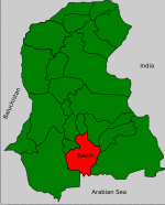
Talhar Tehsil
Talhar | |
|---|---|
Town | |
| Talhar | |
 Main bus stop | |
 The primary bus stop in Talhar is commonly referred to as the Badin stop. | |
| Coordinates: 24°53′N 68°49′E / 24.883°N 68.817°E | |
| Country | Pakistan |
| Province | Sindh Province |
| Area | |
• Total | 269 km2 (104 sq mi) |
| Elevation | 15 m (49 ft) |
| Population (2017) | |
• Total | 172,014 |
• Estimate () | 172,014 |
| • Density | 302/km2 (780/sq mi) |
| Time zone | UTC+5 (PST) |
| Calling code | 72100 |

Talhar (Urdu: تلهار) is a town of Badin District, Sindh, Pakistan. It is located 240 kilometers east of Karachi. The population of 172,014 (2017 census)[1] mostly comprises Sindhi Muslims. Talhar is a Tehsil (an administratively subdivisional unit) of Badin District. Talhar tehsil comprises two town committees, Talhar and Rajo Khanani, and has six union councils.[2]
History
[edit]Badin is a historical district in the Sindh province of Pakistan. It has a rich heritage of ancient civilizations, as it was one of the sites of the Indus Valley civilization that flourished around 2500 BCE. The region was later conquered by various Muslim dynasties, such as the Umayyads, Abbasids, Ghaznavids, and Mughals. The Mughals established their direct rule over Sindh in 1592, after defeating the local rulers. Badin became a separate district in 1975, when it was split from Hyderabad district.[citation needed]

