Talataye
Appearance
Talataye | |
|---|---|
Commune and village | |
| Coordinates: 16°32′N 1°31′E / 16.533°N 1.517°E | |
| Country | |
| Region | Ménaka |
| Control | |
| Area | |
• Total | 8,126 km2 (3,137 sq mi) |
| Population (2009 census)[3] | |
• Total | 13,907 |
| • Density | 1.7/km2 (4.4/sq mi) |
| Time zone | UTC+0 (GMT) |
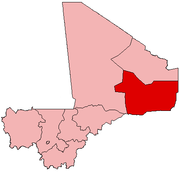
Talataye is a village and rural commune in the Cercle of Ansongo in the Gao Region of south-eastern Mali. The commune has an area of approximately 8,126 square kilometers. In the 2009 census it had a population of 13,907.[3]
References
[edit]- ^ "غاو : النصرة تستعيد السيطرة على مدينة تلاتايت وداعش تنسحب" [Gao: Al-Nusra regains control of the city of Talataye, and ISIS withdraws]. imangahdien.com (in Arabic). 21 June 2023. Retrieved 5 August 2023.
Today, on July 21, 2023, the Jamaat Nusrat al-Islam wa al-Muslimin regained control of the city of Talataye, which is affiliated with Ansongo district, in the state of Gao, according to what was confirmed by informed sources, nearly a year after ISIS took control of it
- ^ Common and Fundamental Operational Datasets Registry: Mali, United Nations Office for the Coordination of Humanitarian Affairs. commune_mali.zip (Originally from the Direction Nationale des Collectivités Territoriales, Mali)
- ^ a b Resultats Recensement Général de la Population et de l’Habitat 2009 (Région de Gao) (PDF) (in French), République de Mali: Institut National de la Statistique.
External links
[edit]- Plan de Sécurité Alimentaire Commune Rurale de Talataye 005-2009 (PDF) (in French), Commissariat à la Sécurité Alimentaire, République du Mali, USAID-Mali, 2005, archived from the original (PDF) on 2012-08-20.


