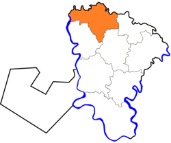
Tala, Egypt
Tala
تلا | |
|---|---|
 | |
 Location in Monufia Governorate | |
| Coordinates: 30°40′48″N 30°56′38″E / 30.680108°N 30.943758°E | |
| Country | |
| Governorate | Monufia |
| Area | |
• Total | 188.3 km2 (72.7 sq mi) |
| Population (2021)[1] | |
• Total | 413,839 |
| • Density | 2,200/km2 (5,700/sq mi) |
| Time zone | UTC+2 (EST) |
| Climate | BWh |
Tala (Arabic: تلا), located in the Nile Delta region of northern Monufia Governorate, Egypt, is known for its lush, fertile landscapes and historical significance. As part of a traditionally agricultural governorate, Tala is surrounded by greenery, with fields of crops and palm trees across its landscape, typical of the Nile Delta’s rich agricultural setting.
The town is characterized by a close-knit community where families have lived for generations, fostering a strong sense of local identity and tradition. Tala’s heritage is deeply rooted in rural Egyptian culture, evident in its food, architecture, and local customs. Alongside its rural atmosphere, Tala boasts a vibrant marketplace where locals gather to trade fresh produce, handmade crafts, and other goods, reflecting the communal lifestyle of the Delta region.
See also
[edit]References
[edit]- ^ a b "Talā (Markaz, Egypt) - Population Statistics, Charts, Map and Location". www.citypopulation.de. Retrieved 18 March 2023.

