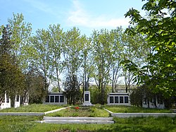
Surs'ko-Mykhailivka
Appearance
Surs'ko-Mykhailivka
Сурсько-Михайлівка | |
|---|---|
Large Village | |
 WW2 Monument in the village | |
| Coordinates: 48°16′17.6″N 34°43′31.0″E / 48.271556°N 34.725278°E | |
| Country | |
| Oblast | |
| Raion | Dnipro Raion |
| Area | |
• Total | 15.9 km2 (6.13 sq mi) |
| Elevation | 70 m (230 ft) |
| Population | |
• Estimate (2021) | 2,552 |
| Time zone | UTC+2 (Eastern European Time) |
| • Summer (DST) | UTC+3 (Eastern European Summer Time) |
| Postal Code | 52411 |
Surs'ko-Mykhailivka, (Ukrainian: Сурсько-Михайлівка) is a large village in the Dnipro Raion of the Dnipropetrovsk Oblast of Ukraine.[1]
The village is located 32 km (20 Miles) to the south-west of the city of Dnipro and 56 km (35 Miles) north-west of the city of Zaporizhzhia.[2] It is located at 70 metres above sea level.[3]
It has an estimated population of 2,552, as of 2021 and has a postal code of 52411.[4] Along with the rest of Ukraine, except Russian-occupied areas, the village follows Eastern European Time (UTC+2) and Eastern European Summer Time (UTC+3) in the summer.
References
[edit]- ^ "Surs'ko-Mykhailivka, Ukraine on the map — exact time, time zone, airports nearby". my.utc.city. Retrieved 2022-12-12.
- ^ "Surs'ko-Mykhailivka (Sursko-Mykhailivka, Sursko-Mixajlovka) - detailed paper map for printing, free download, road maps, topographic map in jpg". en.maps.dokladno.com. Retrieved 2022-12-12.
- ^ "Location of Surs'ko-Mykhailivka". explore.osmaps.com. Retrieved 2022-12-12.
- ^ "GeoNames.org". www.geonames.org. Retrieved 2022-12-12.


