Subprefecture of Campo Limpo
Appearance
Subprefecture of Campo Limpo | |
|---|---|
 Location of the Subprefecture of Campo Limpo in São Paulo | |
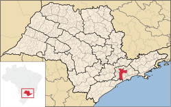
 Location of municipality of São Paulo within the State of São Paulo | |
| Country | |
| Region | Southeast |
| State | |
| Municipality | |
| Administrative Zone | South |
| Districts | Campo Limpo, Capão Redondo, Vila Andrade |
| Government | |
| • Type | Subprefecture |
| • Subprefect | Trajano Conrado Carneiro Neto |
| Area | |
| • Total | 36.67 km2 (14.16 sq mi) |
| Population (2008) | |
| • Total | 578,857 |
| Website | Subprefeitura Campo Limpo (Portuguese) |
The Subprefecture of Campo Limpo is one of 32 subprefectures of the city of São Paulo, Brazil. It comprises three districts: Campo Limpo, Capão Redondo, and Vila Andrade.[1] The slum of Paraisópolis, the second largest of the city and surrounded by middle-to-upper class apartment buildings, is located here.
References
[edit]- ^ Official Subprefecture Website (Portuguese) Archived 2011-01-21 at the Wayback Machine
23°38′S 46°46′W / 23.633°S 46.767°W
